Thursday, October 19, 2023

History Says Expect The Sixth Seal In New York (Revelation 6:12)

            image-8


According to the New York Daily News, Lynn Skyes, lead author of a recent study by seismologists at the Lamont-Doherty Earth Observatory adds that a magnitude-6 quake hits the area about every 670 years, and magnitude-7 every 3,400 years.
A 5.2-magnitude quake shook New York City in 1737 and another of the same severity hit in 1884.
Tremors were felt from Maine to Virginia.
There are several fault lines in the metro area, including one along Manhattan’s 125th St. – which may have generated two small tremors in 1981 and may have been the source of the major 1737 earthquake, says Armbruster.
“The problem here comes from many subtle faults,” explained Skyes after the study was published.
He adds: “We now see there is earthquake activity on them. Each one is small, but when you add them up, they are probably more dangerous than we thought.”
Armbruster says a 5.0-magnitude earthquake today likely would result in casualties and hundreds of millions of dollars in damage.
“I would expect some people to be killed,” he notes.
The scope and scale of damage would multiply exponentially with each additional tick on the Richter scale. (ANI)

East Coast Still Unprepared For The Sixth Seal (Revelation 6:12)

East Coast Earthquake Preparedness
By By BEN NUCKOLS
Posted: 08/25/2011 8:43 am EDT
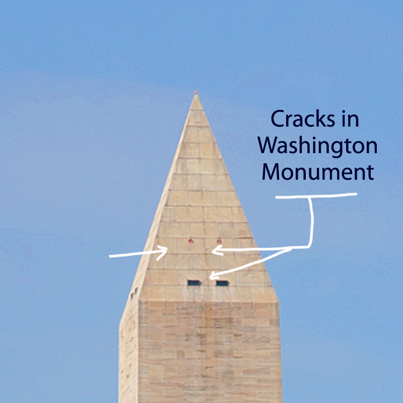
WASHINGTON — There were cracks in the Washington Monument and broken capstones at the National Cathedral. In the District of Columbia suburbs, some people stayed in shelters because of structural concerns at their apartment buildings.
A day after the East Coast’s strongest earthquake in 67 years, inspectors assessed the damage and found that most problems were minor. But the shaking raised questions about whether this part of the country, with its older architecture and inexperience with seismic activity, is prepared for a truly powerful quake.
The 5.8 magnitude quake felt from Georgia north to Canada prompted swift inspections of many structures Wednesday, including bridges and nuclear plants. An accurate damage estimate could take weeks, if not longer. And many people will not be covered by insurance.
In a small Virginia city near the epicenter, the entire downtown business district was closed. School was canceled for two weeks to give engineers time to check out cracks in several buildings.
At the 555-foot Washington Monument, inspectors found several cracks in the pyramidion – the section at the top of the obelisk where it begins narrowing to a point.
A 4-foot crack was discovered Tuesday during a visual inspection by helicopter. It cannot be seen from the ground. Late Wednesday, the National Park Service announced that structural engineers had found several additional cracks inside the top of the monument.
Carol Johnson, a park service spokeswoman, could not say how many cracks were found but said three or four of them were “significant.” Two structural engineering firms that specialize in assessing earthquake damage were being brought in to conduct a more thorough inspection on Thursday.
The monument, by far the tallest structure in the nation’s capital, was to remain closed indefinitely, and Johnson said the additional cracks mean repairs are likely to take longer. It has never been damaged by a natural disaster, including earthquakes in Virginia in 1897 and New York in 1944.
Tourists arrived at the monument Wednesday morning only to find out they couldn’t get near it. A temporary fence was erected in a wide circle about 120 feet from the flags that surround its base. Walkways were blocked by metal barriers manned by security guards.
“Is it really closed?” a man asked the clerk at the site’s bookstore.
“It’s really closed,” said the clerk, Erin Nolan. Advance tickets were available for purchase, but she cautioned against buying them because it’s not clear when the monument will open.
“This is pretty much all I’m going to be doing today,” Nolan said.
Tuesday’s quake was centered about 40 miles northwest of Richmond, 90 miles south of Washington and 3.7 miles underground. In the nearby town of Mineral, Va., Michael Leman knew his Main Street Plumbing & Electrical Supply business would need – at best – serious and expensive repairs.
At worst, it could be condemned. The facade had become detached from the rest of the building, and daylight was visible through a 4- to 6-inch gap that opened between the front wall and ceiling.
“We’re definitely going to open back up,” Leman said. “I’ve got people’s jobs to look out for.”
Leman said he is insured, but some property owners might not be so lucky.
The Insurance Information Institute said earthquakes are not covered under standard U.S. homeowners or business insurance policies, although supplemental coverage is usually available.
The institute says coverage for other damage that may result from earthquakes, such as fire and water damage from burst gas or water pipes, is provided by standard homeowners and business insurance policies in most states. Cars and other vehicles with comprehensive insurance would also be protected.
The U.S. Geological Survey classified the quake as Alert Level Orange, the second-most serious category on its four-level scale. Earthquakes in that range lead to estimated losses between $100 million and $1 billion.
In Culpeper, Va., about 35 miles from the epicenter, walls had buckled at the old sanctuary at St. Stephen’s Episcopal Church, which was constructed in 1821 and drew worshippers including Confederate Gens. Robert E. Lee and J.E.B. Stuart. Heavy stone ornaments atop a pillar at the gate were shaken to the ground. A chimney from the old Culpeper Baptist Church built in 1894 also tumbled down.
At the Washington National Cathedral, spokesman Richard Weinberg said the building’s overall structure remains sound and damage was limited to “decorative elements.”
Massive stones atop three of the four spires on the building’s central tower broke off, crashing onto the roof. At least one of the spires is teetering badly, and cracks have appeared in some flying buttresses.
Repairs were expected to cost millions of dollars – an expense not covered by insurance.
“Every single portion of the exterior is carved by hand, so everything broken off is a piece of art,” Weinberg said. “It’s not just the labor, but the artistry of replicating what was once there.”
The building will remain closed as a precaution. Services to dedicate the memorial honoring Rev. Martin Luther King Jr. were moved.
Other major cities along the East Coast that felt the shaking tried to gauge the risk from another quake.
A few hours after briefly evacuating New York City Hall, Mayor Michael Bloomberg said the city’s newer buildings could withstand a more serious earthquake. But, he added, questions remain about the older buildings that are common in a metropolis founded hundreds of years ago.
“We think that the design standards of today are sufficient against any eventuality,” he said. But “there are questions always about some very old buildings. … Fortunately those tend to be low buildings, so there’s not great danger.”
An earthquake similar to the one in Virginia could do billions of dollars of damage if it were centered in New York, said Barbara Nadel, an architect who specializes in securing buildings against natural disasters and terrorism.
The city’s 49-page seismic code requires builders to prepare for significant shifting of the earth. High-rises must be built with certain kinds of bracing, and they must be able to safely sway at least somewhat to accommodate for wind and even shaking from the ground, Nadel said.
Buildings constructed in Boston in recent decades had to follow stringent codes comparable to anything in California, said Vernon Woodworth, an architect and faculty member at the Boston Architectural College. New construction on older structures also must meet tough standards to withstand severe tremors, he said.
It’s a different story with the city’s older buildings. The 18th- and 19th-century structures in Boston’s Back Bay, for instance, were often built on fill, which can liquefy in a strong quake, Woodworth said. Still, there just aren’t many strong quakes in New England.
The last time the Boston area saw a quake as powerful as the one that hit Virginia on Tuesday was in 1755, off Cape Ann, to the north. A repeat of that quake would likely cause deaths, Woodworth said. Still, the quakes are so infrequent that it’s difficult to weigh the risks versus the costs of enacting tougher building standards regionally, he said.
People in several of the affected states won’t have much time to reflect before confronting another potential emergency. Hurricane Irene is approaching the East Coast and could skirt the Mid-Atlantic region by the weekend and make landfall in New England after that.
In North Carolina, officials were inspecting an aging bridge that is a vital evacuation route for people escaping the coastal barrier islands as the storm approaches.
Speaking at an earthquake briefing Wednesday, Washington Mayor Vincent Gray inadvertently mixed up his disasters.
“Everyone knows, obviously, that we had a hurricane,” he said before realizing his mistake.
“Hurricane,” he repeated sheepishly as reporters and staffers burst into laughter. “I’m getting ahead of myself!”
___
Associated Press writers Sam Hananel in Washington; Alex Dominguez in Baltimore; Bob Lewis in Mineral, Va.; Samantha Gross in New York City; and Jay Lindsay in Boston contributed to this report.

Tuesday, October 17, 2023

Earthquake activity in the New York City area: Revelation 6


Earthquake activity in the New York City area


Wikipedia
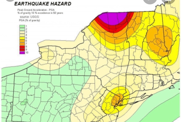
Although the eastern United States is not as seismically active as regions near plate boundaries, large and damaging earthquakes do occur there. Furthermore, when these rare eastern U.S. earthquakes occur, the areas affected by them are much larger than for western U.S. earthquakes of the same magnitude. Thus, earthquakes represent at least a moderate hazard to East Coast cities, including New York City and adjacent areas of very high population density.
Seismicity in the vicinity of New York City. Data are from the U.S. Geological Survey (Top, USGS) and the National Earthquake Information Center (Bottom, NEIC). In the top figure, closed red circles indicate 1924-2006 epicenters and open black circles indicate locations of the larger earthquakes that occurred in 1737, 1783 and 1884. Green lines indicate the trace of the Ramapo fault.
As can be seen in the maps of earthquake activity in this region(shown in the figure), seismicity is scattered throughout most of the New York City area, with some hint of a concentration of earthquakes in the area surrounding Manhattan Island. The largest known earthquake in this region occurred in 1884 and had a magnitude of approximately 5.For this earthquake, observations of fallen bricks and cracked plaster were reported from eastern Pennsylvania to central Connecticut, and the maximum intensity reported was at two sites in western Long Island (Jamaica, New York and Amityville, New York). Two other earthquakes of approximately magnitude 5 occurred in this region in 1737 and 1783. The figure on the right shows maps of the distribution of earthquakes of magnitude 3 and greater that occurred in this region from 1924 to 2010, along with locations of the larger earthquakes that occurred in 1737, 1783 and 1884.

Background

The NYC area is part of the geologically complex structure of the Northern Appalachian Mountains. This complex structure was formed during the past half billion years when the Earth’s crust underlying the Northern Appalachians was the site of two major geological episodes, each of which has left its imprint on the NYC area bedrock. Between about 450 million years ago and about 250 million years ago, the Northern Appalachian region was affected by a continental collision, in which the ancient African continent collided with the ancient North American continent to form the supercontinent Pangaea. Beginning about 200 million years ago, the present-day Atlantic ocean began to form as plate tectonic forces began to rift apart the continent of Pangaea. The last major episode of geological activity to affect the bedrock in the New York area occurred about 100 million years ago, during the Mesozoic era, when continental rifting that led to the opening of the present-day Atlantic ocean formed the Hartford and Newark Mesozoic rift basins.
Earthquake rates in the northeastern United States are about 50 to 200 times lower than in California, but the earthquakes that do occur in the northeastern U.S. are typically felt over a much broader region than earthquakes of the same magnitude in the western U.S.This means the area of damage from an earthquake in the northeastern U.S. could be larger than the area of damage caused by an earthquake of the same magnitude in the western U.S. The cooler rocks in the northeastern U.S. contribute to the seismic energy propagating as much as ten times further than in the warmer rocks of California. A magnitude 4.0 eastern U.S. earthquake typically can be felt as far as 100 km (60 mi) from its epicenter, but it infrequently causes damage near its source. A magnitude 5.5 eastern U.S. earthquake, although uncommon, can be felt as far as 500 km (300 mi) from its epicenter, and can cause damage as far away as 40 km (25 mi) from its epicenter. Earthquakes stronger than about magnitude 5.0 generate ground motions that are strong enough to be damaging in the epicentral area.
At well-studied plate boundaries like the San Andreas fault system in California, scientists can often make observations that allow them to identify the specific fault on which an earthquake took place. In contrast, east of the Rocky Mountains this is rarely the case.  The NYC area is far from the boundaries of the North American plate, which are in the center of the Atlantic Ocean, in the Caribbean Sea, and along the west coast of North America. The seismicity of the northeastern U.S. is generally considered to be due to ancient zones of weakness that are being reactivated in the present-day stress field. In this model, pre-existing faults that were formed during ancient geological episodes persist in the intraplate crust, and the earthquakes occur when the present-day stress is released along these zones of weakness. The stress that causes the earthquakes is generally considered to be derived from present-day rifting at the Mid-Atlantic ridge.

Earthquakes and geologically mapped faults in the Northeastern U.S.

The northeastern U.S. has many known faults, but virtually all of the known faults have not been active for perhaps 90 million years or more. Also, the locations of the known faults are not well determined at earthquake depths. Accordingly, few (if any) earthquakes in the region can be unambiguously linked to known faults. Given the current geological and seismological data, it is difficult to determine if a known fault in this region is still active today and could produce a modern earthquake. As in most other areas east of the Rocky Mountains, the best guide to earthquake hazard in the northeastern U.S. is probably the locations of the past earthquakes themselves.

The Ramapo fault and other New York City area faults

The Ramapo Fault, which marks the western boundary of the Newark rift basin, has been argued to be a major seismically active feature of this region,but it is difficult to discern the extent to which the Ramapo fault (or any other specific mapped fault in the area) might be any more of a source of future earthquakes than any other parts of the region. The Ramapo Fault zone spans more than 185 miles (300 kilometers) in New York, New Jersey, and Pennsylvania. It is a system of faults between the northern Appalachian Mountains and Piedmont areas to the east. This fault is perhaps the best known fault zone in the Mid-Atlantic region, and some small earthquakes have been known to occur in its vicinity. Recently, public knowledge about the fault has increased – especially after the 1970s, when the fault’s proximity to the Indian Point nuclear plant in New York was noticed.
There is insufficient evidence to unequivocally demonstrate any strong correlation of earthquakes in the New York City area with specific faults or other geologic structures in this region. The damaging earthquake affecting New York City in 1884 was probably not associated with the Ramapo fault because the strongest shaking from that earthquake occurred on Long Island (quite far from the trace of the Ramapo fault). The relationship between faults and earthquakes in the New York City area is currently understood to be more complex than any simple association of a specific earthquake with a specific mapped fault.
A 2008 study argued that a magnitude 6 or 7 earthquake might originate from the Ramapo fault zone, which would almost definitely spawn hundreds or even thousands of fatalities and billions of dollars in damage. Studying around 400 earthquakes over the past 300 years, the study also argued that there was an additional fault zone extending from the Ramapo Fault zone into southwestern Connecticut. As can be seen in the above figure of seismicity, earthquakes are scattered throughout this region, with no particular concentration of activity along the Ramapo fault, or along the hypothesized fault zone extending into southwestern Connecticut.
Just off the northern terminus of the Ramapo fault is the Indian Point Nuclear Power Plant, built between 1956 and 1960 by Consolidated Edison Company. The plant began operating in 1963, and it has been the subject of a controversy over concerns that an earthquake from the Ramapo fault will affect the power plant. Whether or not the Ramapo fault actually does pose a threat to this nuclear power plant remains an open question.

Monday, October 16, 2023

USGS Evidence Shows Power of the Sixth Seal (Revelation 6:12)


New Evidence Shows Power of East Coast Earthquakes
Virginia Earthquake Triggered Landslides at Great Distances
Released: 11/6/2012 8:30:00 AM USGS.gov
Earthquake shaking in the eastern United States can travel much farther and cause damage over larger areas than previously thought.
“We used landslides as an example and direct physical evidence to see how far-reaching shaking from east coast earthquakes could be,” said Randall Jibson, USGS scientist and lead author of this study. “Not every earthquake will trigger landslides, but we can use landslide distributions to estimate characteristics of earthquake energy and how far regional ground shaking could occur.”
“Scientists are confirming with empirical data what more than 50 million people in the eastern U.S. experienced firsthand: this was one powerful earthquake,” said USGS Director Marcia McNutt. “Calibrating the distance over which landslides occur may also help us reach back into the geologic record to look for evidence of past history of major earthquakes from the Virginia seismic zone.”
This study will help inform earthquake hazard and risk assessments as well as emergency preparedness, whether for landslides or other earthquake effects.
The research is being presented today at the Geological Society of America conference, and will be published in the December 2012 issue of the Bulletin of the Seismological Society of America.
The USGS found that the farthest landslide from the 2011 Virginia earthquake was 245 km (150 miles) from the epicenter. This is by far the greatest landslide distance recorded from any other earthquake of similar magnitude. Previous studies of worldwide earthquakes indicated that landslides occurred no farther than 60 km (36 miles) from the epicenter of a magnitude 5.8 earthquake.
“What makes this new study so unique is that it provides direct observational evidence from the largest earthquake to occur in more than 100 years in the eastern U.S,” said Jibson. “Now that we know more about the power of East Coast earthquakes, equations that predict ground shaking might need to be revised.”
It is estimated that approximately one-third of the U.S. population could have felt last year’s earthquake in Virginia, more than any earthquake in U.S. history. About 148,000 people reported their ground-shaking experiences caused by the earthquake on the USGS “Did You Feel It?” website. Shaking reports came from southeastern Canada to Florida and as far west as Texas.
In addition to the great landslide distances recorded, the landslides from the 2011 Virginia earthquake occurred in an area 20 times larger than expected from studies of worldwide earthquakes. Scientists plotted the landslide locations that were farthest out and then calculated the area enclosed by those landslides. The observed landslides from last year’s Virginia earthquake enclose an area of about 33,400 km2, while previous studies indicated an expected area of about 1,500 km2from an earthquake of similar magnitude.
“The landslide distances from last year’s Virginia earthquake are remarkable compared to historical landslides across the world and represent the largest distance limit ever recorded,” said Edwin Harp, USGS scientist and co-author of this study. “There are limitations to our research, but the bottom line is that we now have a better understanding of the power of East Coast earthquakes and potential damage scenarios.”
Learn more about the 2011 central Virginia earthquake.

Sunday, October 15, 2023

Quakeland: On the Road to America’s Next Devastating Earthquake: Revelation 6


Quakeland: On the Road to America’s Next Devastating Earthquake
Roger BilhamQuakeland: New York and the Sixth Seal (Revelation 6:12)
Given recent seismic activity — political as well as geological — it’s perhaps unsurprising that two books on earthquakes have arrived this season. One is as elegant as the score of a Beethoven symphony; the other resembles a diary of conversations overheard during a rock concert. Both are interesting, and both relate recent history to a shaky future.
Journalist Kathryn Miles’s Quakeland is a litany of bad things that happen when you provoke Earth to release its invisible but ubiquitous store of seismic-strain energy, either by removing fluids (oil, water, gas) or by adding them in copious quantities (when extracting shale gas in hydraulic fracturing, also known as fracking, or when injecting contaminated water or building reservoirs). To complete the picture, she describes at length the bad things that happen during unprovoked natural earthquakes. As its subtitle hints, the book takes the form of a road trip to visit seismic disasters both past and potential, and seismologists and earthquake engineers who have first-hand knowledge of them. Their colourful personalities, opinions and prejudices tell a story of scientific discovery and engineering remedy.
Miles poses some important societal questions. Aside from human intervention potentially triggering a really damaging earthquake, what is it actually like to live in neighbourhoods jolted daily by magnitude 1–3 earthquakes, or the occasional magnitude 5? Are these bumps in the night acceptable? And how can industries that perturb the highly stressed rocks beneath our feet deny obvious cause and effect? In 2015, the Oklahoma Geological Survey conceded that a quadrupling of the rate of magnitude-3 or more earthquakes in recent years, coinciding with a rise in fracking, was unlikely to represent a natural process. Miles does not take sides, but it’s difficult for the reader not to.
She visits New York City, marvelling at subway tunnels and unreinforced masonry almost certainly scheduled for destruction by the next moderate earthquake in the vicinity. She considers the perils of nuclear-waste storage in Nevada and Texas, and ponders the risks to Idaho miners of rock bursts — spontaneous fracture of the working face when the restraints of many million years of confinement are mined away. She contemplates the ups and downs of the Yellowstone Caldera — North America’s very own mid-continent supervolcano — and its magnificently uncertain future. Miles also touches on geothermal power plants in southern California’s Salton Sea and elsewhere; the vast US network of crumbling bridges, dams and oil-storage farms; and the magnitude 7–9 earthquakes that could hit California and the Cascadia coastline of Oregon and Washington state this century. Amid all this doom, a new elementary school on the coast near Westport, Washington, vulnerable to inbound tsunamis, is offered as a note of optimism. With foresight and much persuasion from its head teacher, it was engineered to become an elevated safe haven.
Miles briefly discusses earthquake prediction and the perils of getting it wrong (embarrassment in New Madrid, Missouri, where a quake was predicted but never materialized; prison in L’Aquila, Italy, where scientists failed to foresee a devastating seismic event) and the successes of early-warning systems, with which electronic alerts can be issued ahead of damaging seismic waves. Yes, it’s a lot to digest, but most of the book obeys the laws of physics, and it is a engaging read. One just can’t help wishing that Miles’s road trips had taken her somewhere that wasn’t a disaster waiting to happen.
Catastrophic damage in Anchorage, Alaska, in 1964, caused by the second-largest earthquake in the global instrumental record.
In The Great Quake, journalist Henry Fountain provides us with a forthright and timely reminder of the startling historical consequences of North America’s largest known earthquake, which more than half a century ago devastated southern Alaska. With its epicentre in Prince William Sound, the 1964 quake reached magnitude 9.2, the second largest in the global instrumental record. It released more energy than either the 2004 Sumatra–Andaman earthquake or the 2011 Tohoku earthquake off Japan; and it generated almost as many pages of scientific commentary and description as aftershocks. Yet it has been forgotten by many.
The quake was scientifically important because it occurred at a time when plate tectonics was in transition from hypothesis to theory. Fountain expertly traces the theory’s historical development, and how the Alaska earthquake was pivotal in nailing down one of the most important predictions. The earthquake caused a fjordland region larger than England to subside, and a similarly huge region of islands offshore to rise by many metres; but its scientific implications were not obvious at the time. Eminent seismologists thought that a vertical fault had slipped, drowning forests and coastlines to its north and raising beaches and islands to its south. But this kind of fault should have reached the surface, and extended deep into Earth’s mantle. There was no geological evidence of a monster surface fault separating these two regions, nor any evidence for excessively deep aftershocks. The landslides and liquefied soils that collapsed houses, and the tsunami that severely damaged ports and infrastructure, offered no clues to the cause.
“Previous earthquakes provide clear guidance about present-day vulnerability.” The hero of The Great Quake is the geologist George Plafker, who painstakingly mapped the height reached by barnacles lifted out of the intertidal zone along shorelines raised by the earthquake, and documented the depths of drowned forests. He deduced that the region of subsidence was the surface manifestation of previously compressed rocks springing apart, driving parts of Alaska up and southwards over the Pacific Plate. His finding confirmed a prediction of plate tectonics, that the leading edge of the Pacific Plate plunged beneath the southern edge of Alaska along a gently dipping thrust fault. That observation, once fully appreciated, was applauded by the geophysics community.
Fountain tells this story through the testimony of survivors, engineers and scientists, interweaving it with the fascinating history of Alaska, from early discovery by Europeans to purchase from Russia by the United States in 1867, and its recent development. Were the quake to occur now, it is not difficult to envisage that with increased infrastructure and larger populations, the death toll and price tag would be two orders of magnitude larger than the 139 fatalities and US$300-million economic cost recorded in 1964.
What is clear from these two books is that seismicity on the North American continent is guaranteed to deliver surprises, along with unprecedented economic and human losses. Previous earthquakes provide clear guidance about the present-day vulnerability of US infrastructure and populations. Engineers and seismologists know how to mitigate the effects of future earthquakes (and, in mid-continent, would advise against the reckless injection of waste fluids known to trigger earthquakes). It is merely a matter of persuading city planners and politicians that if they are tempted to ignore the certainty of the continent’s seismic past, they should err on the side of caution when considering its seismic future.

Thursday, October 12, 2023

The Trend Leading to the Sixth Seal (Revelation 6:12)


HOPKINS
January 14, 2020
Are we seeing a trend? After two small earthquakes hit upstate New York on January 3 and January 7, a slightly larger one was felt near the New York-Canadian border early Monday morning. And while the quake actually happened in an entirely different country, the effects were felt far south into New York state, and the surrounding region.
The United States Geological Survey says the 3.3 magnitude quake hit several mikes south of the town of Ormstown, Quebec a little after 5:30 A.M. There are some slightly conflicting reports, as the Montreal Gazette reports that the quake was a 3.6 magnitude. Ormstown is located around 20 minutes north of the New York border.
The Times Union says the quake was felt as far south as the town of Ticonderoga in Essex County, and as far west as the city of Ogdensburg on the New York-Ontario border. The effects were also felt as far north as Montreal.
No damage was reported.
Yes, earthquakes do happen in the northeastern U.S and Canada occasionally. In December 2019, a 2.1 tremor was reported near Sodus Point, off the coast of Lake Ontario.
Some strike even closer to home. In April 2017, a 1.3 tremor occurred around two and half miles west of Pawling. In early 2016, an even smaller quake happened near Port Chester and Greenwich, CT. In the summer of 2019, a quake struck off the New Jersey coast.
On August 23, 2011, a 5.8 quake, that was centered in Virginia, was felt all the way up the east coast. Several moderate (at least a 5 on the richter scale) quakes have occurred near New York City in 1737, 1783 and 1884.
Listen to Middays With Hopkins weekdays from 10AM to 2PM on 101.5 WPDH. Stream us live through the website, Alexa-enabled device, Google Home or the WPDH mobile app.

Tuesday, October 10, 2023

East Coast Quakes and the Sixth Seal: Revelation 6


Items lie on the floor of a grocery store after an earthquake on Sunday, August 9, 2020 in North Carolina.

East Coast Quakes: What to Know About the Tremors Below

By Meteorologist Dominic Ramunni Nationwide PUBLISHED 7:13 PM ET Aug. 11, 2020 PUBLISHED 7:13 PM EDT Aug. 11, 2020

People across the Carolinas and Mid-Atlantic were shaken, literally, on a Sunday morning as a magnitude 5.1 earthquake struck in North Carolina on August 9, 2020.

Centered in Sparta, NC, the tremor knocked groceries off shelves and left many wondering just when the next big one could strike.

Fault Lines

Compared to the West Coast, there are far fewer fault lines in the East. This is why earthquakes in the East are relatively uncommon and weaker in magnitude.

That said, earthquakes still occur in the East.

According to Spectrum News Meteorologist Matthew East, “Earthquakes have occurred in every eastern U.S. state, and a majority of states have recorded damaging earthquakes. However, they are pretty rare. For instance, the Sparta earthquake Sunday was the strongest in North Carolina in over 100 years.”

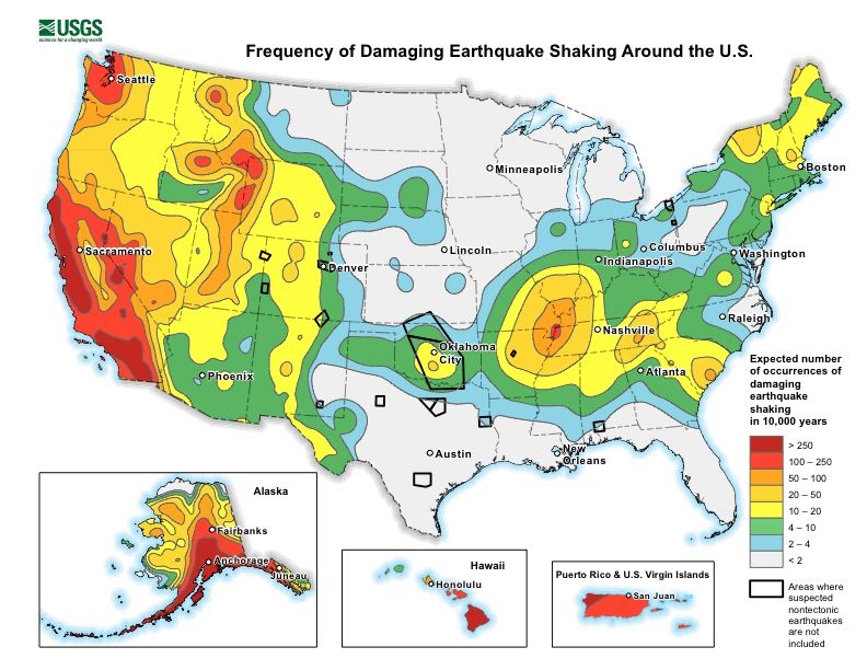
While nowhere near to the extent of the West Coast, damaging earthquakes can and do affect much of the eastern half of the country.

For example, across the Tennesse River Valley lies the New Madrid Fault Line. While much smaller in size than those found farther west, the fault has managed to produce several earthquakes over magnitude 7.0 in the last couple hundred years.

In 1886, an estimated magnitude 7.0 struck Charleston, South Carolina along a previously unknown seismic zone. Nearly the entire town had to be rebuilt.

Vulnerabilities

The eastern half of the U.S. has its own set of vulnerabilities from earthquakes.

Seismic waves actually travel farther in the East as opposed to the West Coast. This is because the rocks that make up the East are tens, if not hundreds, of millions of years older than in the West.

These older rocks have had much more time to bond together with other rocks under the tremendous pressure of Earth’s crust. This allows seismic energy to transfer between rocks more efficiently during an earthquake, causing the shaking to be felt much further.

This is why, during the latest quake in North Carolina, impacts were felt not just across the state, but reports of shaking came as far as Atlanta, Georgia, nearly 300 miles away.

Reports of shaking from different earthquakes of similar magnitude.

Quakes in the East can also be more damaging to infrastructure than in the West. This is generally due to the older buildings found east. Architects in the early-to-mid 1900s simply were not accounting for earthquakes in their designs for cities along the East Coast.

When a magnitude 5.8 earthquake struck Virginia in 2011, not only were numerous historical monuments in Washington, D.C. damaged, shaking was reported up and down the East Coast with tremors even reported in Canada.

Unpredictable

There is no way to accurately predict when or where an earthquake may strike.

Some quakes will have a smaller earthquake precede the primary one. This is called a foreshock.

The problem is though, it’s difficult to say whether the foreshock is in fact a foreshock and not the primary earthquake. Only time will tell the difference.

The United State Geological Survey (USGS) is experimenting with early warning detection systems in the West Coast.

While this system cannot predict earthquakes before they occur, they can provide warning up to tens of seconds in advance that shaking is imminent. This could provide just enough time to find a secure location before the tremors begin.

Much like hurricanes, tornadoes, or snowstorms, earthquakes are a natural occuring phenomenon that we can prepare for.

The USGS provides an abundance of resources on how to best stay safe when the earth starts to quake.