Nuclear power plant in Buchanan, New York
Indian Point Energy Center (IPEC) is a three-unit nuclear power plant station located in Buchanan, New York, just south of Peekskill. It sits on the east bank of the Hudson River, about 36 miles (58 km) north of Midtown Manhattan. The plant generates over 2,000 megawatts (MWe) of electrical power. For reference, the record peak energy consumption of New York City and Westchester County (the ConEdison Service Territory) was set during a seven-day heat wave on July 19, 2013, at 13,322 megawatts.[3] Electrical energy consumption varies greatly with time of day and season.[4]
Quick Facts: Country, Location …
The plant is owned and operated by Entergy Nuclear Northeast, a subsidiary of Entergy Corporation, and includes two operating Westinghouse pressurized water reactors—designated “Indian Point 2” and “Indian Point 3″—which Entergy bought from Consolidated Edison and the New York Power Authority respectively. The facility also contains the permanently shut-down Indian Point Unit 1 reactor. As of 2015, the number of permanent jobs at the Buchanan plant is approximately 1,000.
The original 40-year operating licenses for units 2 and 3 expired in September 2013 and December 2015, respectively. Entergy had applied for license extensions and the Nuclear Regulatory Commission (NRC) was moving toward granting a twenty-year extension for each reactor. However, after pressure from local environmental groups and New York governor Andrew Cuomo, it was announced that the plant is scheduled to be shut down by 2021.[5] Local groups had cited increasingly frequent issues with the aging units, ongoing environmental releases, and the proximity of the plant to New York City.[6]
Reactors
History and design
The reactors are built on land that originally housed the Indian Point Amusement Park, but was acquired by Consolidated Edison (ConEdison) on October 14, 1954.[7] Indian Point 1, built by ConEdison, was a 275-megawatt Babcock & Wilcox supplied [8] pressurized water reactor that was issued an operating license on March 26, 1962 and began operations on September 16, 1962.[9] The first core used a thorium-based fuel with stainless steel cladding, but this fuel did not live up to expectations for core life.[10] The plant was operated with uranium dioxide fuel for the remainder of its life. The reactor was shut down on October 31, 1974, because the emergency core cooling system did not meet regulatory requirements. All spent fuel was removed from the reactor vessel by January 1976, but the reactor still stands.[11] The licensee, Entergy, plans to decommission Unit 1 when Unit 2 is decommissioned.[12]
The two additional reactors, Indian Point 2 and 3, are four-loop Westinghouse pressurized water reactors both of similar design. Units 2 and 3 were completed in 1974 and 1976, respectively. Unit 2 has a generating capacity of 1,032 MW, and Unit 3 has a generating capacity of 1,051 MW. Both reactors use uranium dioxide fuel of no more than 4.8% U-235 enrichment. The reactors at Indian Point are protected by containment domes made of steel-reinforced concrete that is 40 inches thick, with a carbon steel liner.[13]
Nuclear capacity in New York state
Units 2 and 3 are two of six operating nuclear energy sources in New York State. New York is one of the five largest states in terms of nuclear capacity and generation, accounting for approximately 5% of the national totals. Indian Point provides 39% of the state’s nuclear capacity. Nuclear power produces 34.2% of the state’s electricity, higher than the U.S. average of 20.6%. In 2017, Indian Point generated approximately 10% of the state’s electricity needs, and 25% of the electricity used in New York City and Westchester County.[14] Its contract with Consolidated Edison is for just 560 megawatts. The New York Power Authority, which built Unit 3, stopped buying electricity from Indian Point in 2012. NYPA supplies the subways, airports, and public schools and housing in NYC and Westchester County. Entergy sells the rest of Indian Point’s output into the NYISO administered electric wholesale markets and elsewhere in New England.[15][16][17][18] In 2013, New York had the fourth highest average electricity prices in the United States. Half of New York’s power demand is in the New York City region; about two-fifths of generation originates there.[19][20]
Refueling
The currently operating Units 2 and 3 are each refueled on a two-year cycle. At the end of each fuel cycle, one unit is brought offline for refueling and maintenance activities. On March 2, 2015, Indian Point 3 was taken offline for 23 days to perform its refueling operations. Entergy invested $50 million in the refueling and other related projects for Unit 3, of which $30 million went to employee salaries. The unit was brought back online on March 25, 2015.[21]
Effects
Economic impact
A June 2015 report by a lobby group called Nuclear Energy Institute found that the operation of Indian Point generates $1.3 billion of annual economic output in local counties, $1.6 billion statewide, and $2.5 billion across the United States. In 2014, Entergy paid $30 million in state and local property taxes. The total tax revenue (direct and secondary) was nearly $340 million to local, state, and federal governments.[15] According to the Village of Buchanan budget for 2016–2017, a payment in lieu of taxes in the amount of $2.62 million was received in 2015-2016, and was projected to be $2.62 million in 2016–2017 – the majority of which can be assumed to come from the Indian Point Energy Center.[22]
Over the last decade, the station has maintained a capacity factor of greater than 93 percent. This is consistently higher than the nuclear industry average and than other forms of generation. The reliability helps offset the severe price volatility of other energy sources (e.g., natural gas) and the indeterminacy of renewable electricity sources (e.g., solar, wind).[15]
Indian Point directly employs about 1,000 full-time workers. This employment creates another 2,800 jobs in the five-county region, and 1,600 in other industries in New York, for a total of 5,400 in-state jobs. Additionally, another 5,300 indirect jobs are created out of state, creating a sum total of 10,700 jobs throughout the United States.[15]
Environmental concerns
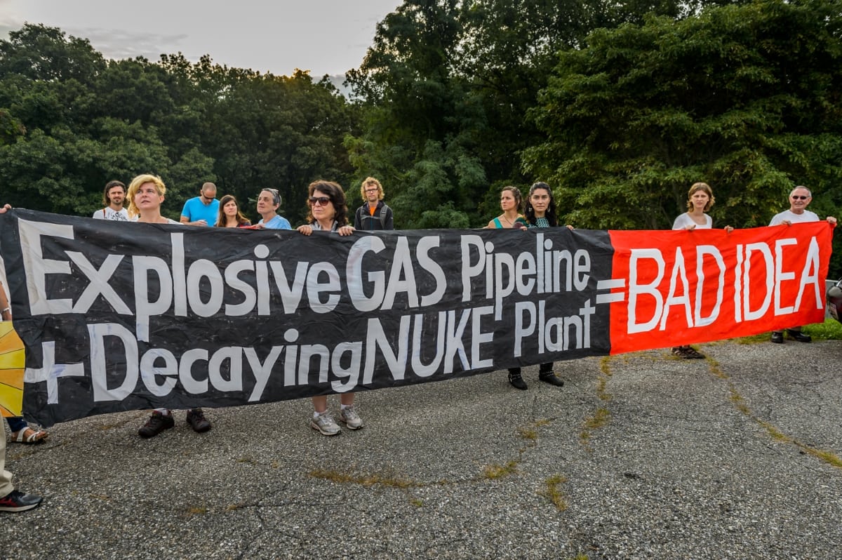
Environmentalists have expressed concern about increased carbon emissions with the impending shutdown of Indian Point (generating electricity with nuclear energy creates no carbon emissions). A study undertaken by Environmental Progress found that closure of the plant would cause power emissions to jump 29% in New York, equivalent to the emissions from 1.4 million additional cars on New York roads.[23]
Some environmental groups have expressed concerns about the operation of Indian Point, including radiation pollution and endangerment of wildlife, but whether Indian Point has ever posed a significant danger to wildlife or the public remains controversial. Though anti-nuclear group Riverkeeper notes “Radioactive leakage from the plant containing several radioactive isotopes, such as strontium-90, cesium-137, cobalt-60, nickel-63 and tritium, a rarely-occurring isotope of hydrogen, has flowed into groundwater that eventually enters the Hudson River in the past[24], there is no evidence radiation from the plant has ever posed a significant hazard to local residents or wildlife. In the last year[when?], nine tritium leaks have occurred, however, even at their highest levels the leaks have never exceeded one-tenth of one percent of US Nuclear Regulatory Commission limits.
In February 2016, New York State Governor Andrew Cuomo called for a full investigation by state environment[25] and health officials and is partnering with organizations like Sierra Club, Riverkeepers, Hudson River Sloop Clearwater, Indian Point Safe Energy Coalition, Scenic Hudson and Physicians for Social Responsibility in seeking the permanent closure of the plant.[citation needed] However, Cuomo’s motivation for closing the plant was called into question after it was revealed two top former aides, under federal prosecution for influence-peddling, had lobbied on behalf of natural gas company Competitive Power Ventures (CPV) to kill Indian Point. In his indictment, US attorney Preet Bharara wrote “the importance of the plant [CPV’s proposed Valley Energy Center, a plant powered by natural gas] to the State depended at least in part, on whether [Indian Point] was going to be shut down.”[26]
In April 2016 climate scientist James Hansen took issue with calls to shut the plant down, including those from presidential candidate Bernie Sanders. “The last few weeks have seen an orchestrated campaign to mislead the people of New York about the essential safety and importance of Indian Point nuclear plant to address climate change,” wrote Hansen, adding “Sanders has offered no evidence that NRC [U.S. Nuclear Regulatory Commission] has failed to do its job, and he has no expertise in over-riding NRC’s judgement. For the sake of future generations who could be harmed by irreversible climate change, I urge New Yorkers to reject this fear mongering and uphold science against ideology.”[27]
Indian Point removes water from the nearby Hudson River. Despite the use of fish screens, the cooling system kills over a billion fish eggs and larvae annually.[28] According to one NRC report from 2010, as few as 38% of alewives survive the screens.[29] On September 14, 2015, a state hearing began in regards to the deaths of fish in the river, and possibly implementing a shutdown period from May to August. An Indian Point spokesman stated that such a period would be unnecessary, as Indian Point “is fully protective of life in the Hudson River and $75 million has been spent over the last 30 years on scientific studies demonstrating that the plant has no harmful impact to adult fish.” The hearings lasted three weeks.[30] Concerns were also raised over the planned building of new cooling towers, which would cut down forest land that is suspected to be used as breeding ground by muskrat and mink. At the time of the report, no minks or muskrats were spotted there.[29]
Safety
Indian Point Energy Center has been given an incredible amount of scrutiny from the media and politicians and is regulated more heavily than various other power plants in the state of New York (i.e., by the NRC in addition to FERC, the NYSPSC, the NYISO, the NYSDEC, and the EPA). On a forced outage basis – incidents related to electrical equipment failure that force a plant stoppage – it provides a much more reliable operating history than most other power plants in New York.[31][32] Beginning at the end of 2015, Governor Cuomo began to ramp up political action against the Indian Point facility, opening an investigation with the state public utility commission, the department of health, and the department of environmental conservation.[33][34][35][30][36][37] To put the public service commission investigation in perspective: most electric outage investigations conducted by the commission are in response to outages with a known number of affected retail electric customers.[38] By November 17, 2017, the NYISO accepted Indian Point’s retirement notice.[39]
In 1997, Indian Point Unit 3 was removed from the NRC’s list of plants that receive increased attention from the regulator. An engineer for the NRC noted that the plant had been experiencing increasingly fewer problems during inspections.[40] On March 10, 2009 the Indian Point Power Plant was awarded the fifth consecutive top safety rating for annual operations by the Federal regulators. According to the Hudson Valley Journal News, the plant had shown substantial improvement in its safety culture in the previous two years.[41] A 2003 report commissioned by then-Governor George Pataki concluded that the “current radiological response system and capabilities are not adequate to…protect the people from an unacceptable dose of radiation in the event of a release from Indian Point”.[42] More recently, in December 2012 Entergy commissioned a 400-page report on the estimates of evacuation times. This report, performed by emergency planning company KLD Engineering, concluded that the existing traffic management plans provided by Orange, Putnam, Rockland, and Westchester Counties are adequate and require no changes.[43] According to one list that ranks U.S. nuclear power plants by their likelihood of having a major natural disaster related incident, Indian Point is the most likely to be hit by a natural disaster, mainly an earthquake.[44][45][46][47] Despite this, the owners of the plant still say that safety is a selling point for the nuclear power plant.[48]
 In 1973, five months after Indian Point 2 opened, the plant was shut down when engineers discovered buckling in the steel liner of the concrete dome in which the nuclear reactor is housed.[49] On October 17, 1980,[50] 100,000 gallons of Hudson River water leaked into the Indian Point 2 containment building from the fan cooling unit, undetected by a safety device designed to detect hot water. The flooding, covering the first nine feet of the reactor vessel, was discovered when technicians entered the building. Two pumps that should have removed the water were found to be inoperative. NRC proposed a $2,100,000 fine for the incident. In February 2000, Unit 2 experienced a Steam Generator Tube Rupture (SGTR), which allowed primary water to leak into the secondary system through one of the steam generators.[51] All four steam generators were subsequently replaced.[citation needed] In 2005, Entergy workers while digging discovered a small leak in a spent fuel pool. Water containing tritium and strontium-90 was leaking through a crack in the pool building and then finding its way into the nearby Hudson River. Workers were able to keep the spent fuel rods safely covered despite the leak.[52] On March 22, 2006 The New York Times also reported finding radioactive nickel-63 and strontium in groundwater on site.[53] In 2007, a transformer at Unit 3 caught fire, and the Nuclear Regulatory Commission raised its level of inspections, because the plant had experienced many unplanned shutdowns. According to The New York Times, Indian Point “has a history of transformer problems”.[54] On April 23, 2007, the Nuclear Regulatory Commission fined the owner of the Indian Point nuclear plant $130,000 for failing to meet a deadline for a new emergency siren plan. The 150 sirens at the plant are meant to alert residents within 10 miles to a plant emergency.[55] On January 7, 2010, NRC inspectors reported that an estimated 600,000 gallons of mildly radioactive steam was intentionally vented to the atmosphere after an automatic shutdown of Unit 2. After the vent, one of the vent valves unintentionally remained slightly open for two days. The levels of tritium in the steam were within the allowable safety limits defined in NRC standards.[56] On November 7, 2010, an explosion occurred in a main transformer for Indian Point 2, spilling oil into the Hudson River.[57] Entergy later agreed to pay a $1.2 million penalty for the transformer explosion.[54] July 2013, a former supervisor, who worked at the Indian Point nuclear power plant for twenty-nine years, was arrested for falsifying the amount of particulate in the diesel fuel for the plant’s backup generators.[58] On May 9, 2015, a transformer failed at Indian Point 3, causing the automated shutdown of reactor 3. A fire that resulted from the failure was extinguished, and the reactor was placed in a safe and stable condition.[59] The failed transformer contained about 24,000 gallons of dielectric fluid, which is used as an insulator and coolant when the transformer is energized. The U.S. Coast Guard estimates that about 3,000 gallons of dielectric fluid entered the river following the failure.[60] In June 2015, a mylar balloon floated into a switchyard, causing an electrical problem resulting in the shutdown of Reactor 3.[61] In July 2015, Reactor 3 was shut down after a water pump failure.[citation needed] On December 5, 2015, Indian Point 2 was shut down after several control rods lost power.[62] On February 6, 2016, Governor Andrew Cuomo informed the public that radioactive tritium-contaminated water leaked into the groundwater at the Indian Point Nuclear facility.[25]
Spent fuel
Indian Point stores used fuel rods in two spent fuel pools at the facility.[52] The spent fuel pools at Indian Point are not stored under a containment dome like the reactor, but rather they are contained within an indoor 40-foot-deep pool and submerged under 27 feet of water. Water is a natural and effective barrier to radiation. The spent fuel pools at Indian Point are set in bedrock and are constructed of concrete walls that are four to six feet wide, with a quarter-inch thick stainless steel inner liner. The pools each have multiple redundant backup cooling systems.[52][63]
Indian Point began dry cask storage of spent fuel rods in 2008, which is a safe and environmentally sound option according to the Nuclear Regulatory Commission.[64] Some rods have already been moved to casks from the spent fuel pools. The pools will be kept nearly full of spent fuel, leaving enough space to allow emptying the reactor completely.[65] Dry cask storage systems are designed to resist floods, tornadoes, projectiles, temperature extremes, and other unusual scenarios. The NRC requires the spent fuel to be cooled and stored in the spent fuel pool for at least five years before being transferred to dry casks.[66]
Earthquake risk
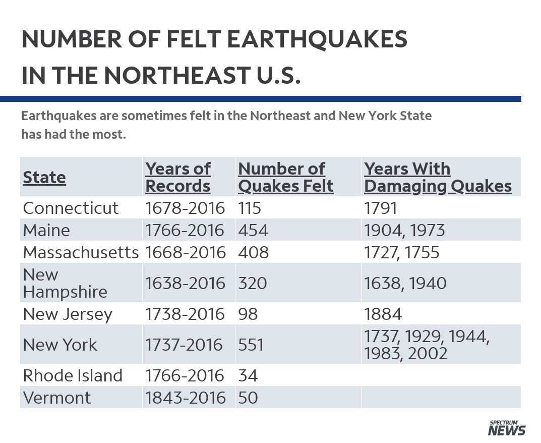
In 2008, researchers from Columbia University’s Lamont-Doherty Earth Observatory located a previously unknown active seismic zone running from Stamford, Connecticut, to the Hudson Valley town of Peekskill, New York—the intersection of the Stamford-Peekskill line with the well-known Ramapo Fault—which passes less than a mile north of the Indian Point nuclear power plant.[67] The Ramapo Fault is the longest fault in the Northeast, but scientists dispute how active this roughly 200-million-year-old fault really is. Many earthquakes in the state’s surprisingly varied seismic history are believed to have occurred on or near it. Visible at ground level, the fault line likely extends as deep as nine miles below the surface.[68]
In July 2013, Entergy engineers reassessed the risk of seismic damage to Unit 3 and submitted their findings in a report to the NRC. It was found that risk leading to reactor core damage is 1 in 106,000 reactor years using U.S. Geological Survey data; and 1 in 141,000 reactor years using Electric Power Research Institute data. Unit 3’s previous owner, the New York Power Authority, had conducted a more limited analysis in the 1990s than Unit 2’s previous owner, Con Edison, leading to the impression that Unit 3 had fewer seismic protections than Unit 2. Neither submission of data from the previous owners was incorrect.[69]
According to a company spokesman, Indian Point was built to withstand an earthquake of 6.1 on the Richter scale.[70] Entergy executives have also noted “that Indian Point had been designed to withstand an earthquake much stronger than any on record in the region, though not one as powerful as the quake that rocked Japan.”[71]
The Nuclear Regulatory Commission’s estimate of the risk each year of an earthquake intense enough to cause core damage to the reactor at Indian Point was Reactor 2: 1 in 30,303; Reactor 3: 1 in 10,000, according to an NRC study published in August 2010. Msnbc.com reported based on the NRC data that “Indian Point nuclear reactor No. 3 has the highest risk of earthquake damage in the country, according to new NRC risk estimates provided to msnbc.com.” According to the report, the reason is that plants in known earthquake zones like California were designed to be more quake-resistant than those in less affected areas like New York.[72][73] The NRC did not dispute the numbers but responded in a release that “The NRC results to date should not be interpreted as definitive estimates of seismic risk,” because the NRC does not rank plants by seismic risk.[74]
IPEC Units 2 and 3 both operated at 100% full power before, during, and after the Virginia earthquake on August 23, 2011. A thorough inspection of both units by plant personnel immediately following this event verified no significant damage occurred at either unit.
Emergency planning
The Nuclear Regulatory Commission defines two emergency planning zones around nuclear power plants: a plume exposure pathway zone with a radius of 10 miles (16 km), concerned primarily with exposure to, and inhalation of, airborne radioactive contamination, and an ingestion pathway zone of about 50 miles (80 km), concerned primarily with ingestion of food and liquid contaminated by radioactivity.[75]
According to an analysis of U.S. Census data for MSNBC, the 2010 U.S. population within 10 miles (16 km) of Indian Point was 272,539, an increase of 17.6 percent during the previous ten years. The 2010 U.S. population within 50 miles (80 km) was 17,220,895, an increase of 5.1 percent since 2000. Cities within 50 miles include New York (41 miles to city center); Bridgeport, Conn. (40 miles); Newark, N.J. (39 miles); and Stamford, Conn. (24 miles).[76]
In the wake of the 2011 Fukushima incident in Japan, the State Department recommended that any Americans in Japan stay beyond fifty miles from the area.[citation needed] Columnist Peter Applebome, writing in The New York Times, noted that such an area around Indian Point would include “almost all of New York City except for Staten Island; almost all of Nassau County and much of Suffolk County; all of Bergen County, N.J.; all of Fairfield, Conn.” He quotes Purdue University professor Daniel Aldrich as saying “Many scholars have already argued that any evacuation plans shouldn’t be called plans, but rather “fantasy documents””.[42]
The current 10-mile plume-exposure pathway Emergency Planning Zone (EPZ) is one of two EPZs intended to facilitate a strategy for protective action during an emergency and comply with NRC regulations. “The exact size and shape of each EPZ is a result of detailed planning which includes consideration of the specific conditions at each site, unique geographical features of the area, and demographic information. This preplanned strategy for an EPZ provides a substantial basis to support activity beyond the planning zone in the extremely unlikely event it would be needed.”[77]
In an interview, Entergy executives said they doubt that the evacuation zone would be expanded to reach as far as New York City.[71]
Indian Point is protected by federal, state, and local law enforcement agencies, including a National Guard base within a mile of the facility, as well as by private off-site security forces.[78]
During the September 11 attacks, American Airlines Flight 11 flew near the Indian Point Energy Center en route to the World Trade Center. Mohamed Atta, one of the 9/11 hijackers/plotters, had considered nuclear facilities for targeting in a terrorist attack.[79] Entergy says it is prepared for a terrorist attack, and asserts that a large airliner crash into the containment building would not cause reactor damage.[80] Following 9/11 the NRC required operators of nuclear facilities in the U.S. to examine the effects of terrorist events and provide planned responses.[81] In September 2006, the Indian Point Security Department successfully completed mock assault exercises required by the Nuclear Regulatory Commission.[citation needed] However, according to environmental group Riverkeeper, these NRC exercises are inadequate because they do not envision a sufficiently large group of attackers.[citation needed]
According to The New York Times, fuel stored in dry casks is less vulnerable to terrorist attack than fuel in the storage pools.[65]
Recertification
Units 2 and 3 were both originally licensed by the NRC for 40 years of operation. The NRC limits commercial power reactor licenses to an initial 40 years, but also permits such licenses to be renewed. This original 40-year term for reactor licenses was based on economic and antitrust considerations, not on limitations of nuclear technology. Due to this selected period, however, some structures and components may have been engineered on the basis of an expected 40-year service life.[82] The original federal license for Unit Two expired on September 28, 2013,[83][84] and the license for Unit Three was due to expire in December 2015.[85] On April 30, 2007, Entergy submitted an application for a 20-year renewal of the licenses for both units. On May 2, 2007, the NRC announced that this application is available for public review.[86] Because the owner submitted license renewal applications at least five years prior to the original expiration date, the units are allowed to continue operation past this date while the NRC considers the renewal application.
On September 23, 2007, the antinuclear group Friends United for Sustainable Energy (FUSE) filed legal papers with the NRC opposing the relicensing of the Indian Point 2 reactor. The group contended that the NRC improperly held Indian Point to less stringent design requirements. The NRC responded that the newer requirements were put in place after the plant was complete.[87]
On December 1, 2007, Westchester County Executive Andrew J. Spano, New York Attorney General Andrew Cuomo, and New York Governor Eliot Spitzer called a press conference with the participation of environmental advocacy groups Clearwater and Riverkeeper to announce their united opposition to the re-licensing of the Indian Point nuclear power plants. The New York State Department of Environmental Conservation and the Office of the Attorney General requested a hearing as part of the process put forth by the Nuclear Regulatory Commission.[citation needed] In September 2007 The New York Times reported on the rigorous legal opposition Entergy faces in its request for a 20-year licensing extension for Indian Point Nuclear Reactor 2.[87]
A water quality certificate is a prerequisite for a twenty-year renewal by the NRC.[citation needed] On April 3, 2010, the New York State Department of Environmental Conservation ruled that Indian Point violates the federal Clean Water Act,[88] because “the power plant’s water-intake system kills nearly a billion aquatic organisms a year, including the shortnose sturgeon, an endangered species.”[citation needed] The state is demanding that Entergy constructs new closed-cycle cooling towers at a cost of over $1 billion, a decision that will effectively close the plant for nearly a year. Regulators denied Entergy’s request to install fish screens that they said would improve fish mortality more than new cooling towers. Anti-nuclear groups and environmentalists have in the past tried to close the plant,[citation needed] which is in a more densely populated area than any of the 66 other nuclear plant sites in the US.[citation needed] Opposition to the plant[from whom?] increased after the September 2001 terror attacks,[citation needed] when one of the hijacked jets flew close to the plant on its way to the World Trade Center.[citation needed] Public worries also increased after the 2011 Japanese Fukushima Daiichi nuclear disaster and after a report highlighting the Indian Point plant’s proximity to the Ramapo Fault.[citation needed]
Advocates of recertifying Indian Point include former New York City mayors Michael Bloomberg and Rudolph W. Giuliani. Bloomberg says that “Indian Point is critical to the city’s economic viability”.[89] The New York Independent System Operator maintains that in the absence of Indian Point, grid voltages would degrade, which would limit the ability to transfer power from upstate New York resources through the Hudson Valley to New York City.[90]
As the current governor, Andrew Cuomo continues to call for closure of Indian Point.[91] In late June 2011, a Cuomo advisor in a meeting with Entergy executives informed them for the first time directly of the Governor’s intention to close the plant, while the legislature approved a bill to streamline the process of siting replacement plants.[92]
Nuclear energy industry figures and analysts responded to Cuomo’s initiative by questioning whether replacement electrical plants could be certified and built rapidly enough to replace Indian Point, given New York state’s “cumbersome regulation process”, and also noted that replacement power from out of state sources will be hard to obtain because New York has weak ties to generation capacity in other states.[citation needed] They said that possible consequences of closure will be a sharp increase in the cost of electricity for downstate users and even “rotating black-outs”.[93]
Several members of the House of Representatives representing districts near the plant have also opposed recertification, including Democrats Nita Lowey, Maurice Hinchey, and Eliot Engel and then Republican member Sue Kelly.[94]
In November 2016 the New York Court of Appeals ruled that the application to renew the NRC operating licences must be reviewed against the state’s coastal management program, which The New York State Department of State had already decided was inconsistent with coastal management requirements. Entergy has filed a lawsuit regarding the validity of Department of State’s decision.[95]
Closure
Beginning at the end of 2015, Governor Cuomo began to ramp up political action against the Indian Point facility, opening investigations with the state public utility commission, the department of health and the department of environmental conservation.[33][34][35][30][36][37] To put the public service commission investigation in perspective, most electric outage investigations conducted by the commission are in response to outages with a known number of affected retail electric customers.[38] By November 17, 2017, the NYISO accepted Indian Point’s retirement notice.[39]
In January 2017, the governor’s office announced closure by 2020-21.[96] The closure, along with pollution control, challenges New York’s ability to be supplied.[citation needed] Among the solution proposals are storage, renewables (solar and wind), a new transmission cables from Canada [97][98] and a 650MW natural gas plant located in Wawayanda, New York.[99] There was also a 1,000 MW merchant HVDC transmission line proposed in 2013 to the public service commission that would have interconnected at Athens, New York and Buchanan, New York, however this project was indefinitely stalled when its proposed southern converter station site was bought by the Town of Cortlandt in a land auction administered by Con Edison.[100][101][102] As of October 1, 2018, the 650 MW plant built in Wawayanda, New York, by CPV Valley, is operating commercially.[103] The CPV Valley plant has been associated with Governor Cuomo’s close aid, Joe Percoco, and the associated corruption trial.[104] Another plant being built, Cricket Valley Energy Center, rated at 1,100 MW, is on schedule to provide energy by 2020 in Dover, New York.[105] An Indian Point contingency plan, initiated in 2012 by the NYSPSC under the administration of Cuomo, solicited energy solutions from which a Transmission Owner Transmission Solutions (TOTS) plan was selected. The TOTS projects provide 450 MW[106] of additional transfer capability across a NYISO defined electric transmission corridor in the form of three projects: series compensation at a station in Marcy, New York, reconductoring a transmission line, adding an additional transmission line, and “unbottling” Staten Island capacity. These projects, with the exception of part of the Staten Island “unbottling” were in service by mid-2016. The cost of the TOTS projects are distributed among various utilities in their rate cases before the public service commission and the cost allocation amongst themselves was approved by FERC. NYPA and LIPA are also receiving a portion. The cost of the TOTS projects has been estimated in the range of $27 million to $228 million.[107][108][109][110][111] An energy highway initiative was also prompted by this order (generally speaking, additional lines on the Edic-Pleasant Valley and the Oakdale-Fraser transmission corridors) which is still going through the regulatory process in both the NYISO and NYSPSC.
Under the current plan, one reactor is scheduled to be shut down in April 2020 and the second by April 2021.[112] A report by the New York Building Congress, a construction industry association, has said that NYC will need additional natural gas pipelines to accommodate the city’s increasing demand for energy. Environmentalists have argued that the power provided by Indian point can be replaced by renewable energy, combined with conservation measures and improvements to the efficiency of the electrical grid.[113]