Showing posts with label nyc. Show all posts

Thursday, August 6, 2026

The Sixth Seal in NYC Long Overdue (Revelation 6)


The Big One Awaits
By MARGO NASH
Published: March 25, 2001
Alexander Gates, a geology professor at Rutgers-Newark, is co-author of “The Encyclopedia of Earthquakes and Volcanoes,“ which will be published by Facts on File in July. He has been leading a four-year effort to remap an area known as the Sloatsburg Quadrangle, a 5-by-7-mile tract near Mahwah that crosses into New York State. The Ramapo Fault, which runs through it, was responsible for a big earthquake in 1884, and Dr. Gates warns that a recurrence is overdue. He recently talked about his findings.
Q. What have you found?
A. We’re basically looking at a lot more rock, and we’re looking at the fracturing and jointing in the bedrock and putting it on the maps. Any break in the rock is a fracture. If it has movement, then it’s a fault. There are a lot of faults that are offshoots of the Ramapo. Basically when there are faults, it means you had an earthquake that made it. So there was a lot of earthquake activity to produce these features. We are basically not in a period of earthquake activity along the Ramapo Fault now, but we can see that about six or seven times in history, about 250 million years ago, it had major earthquake activity. And because it’s such a fundamental zone of weakness, anytime anything happens, the Ramapo Fault goes.
Q. Where is the Ramapo Fault?
 A. The fault line is in western New Jersey and goes through a good chunk of the state, all the way down to Flemington. It goes right along where they put in the new 287. It continues northeast across the Hudson River right under the Indian Point power plant up into Westchester County. There are a lot of earthquakes rumbling around it every year, but not a big one for a while.
Q. Did you find anything that surprised you?
A. I found a lot of faults, splays that offshoot from the Ramapo that go 5 to 10 miles away from the fault. I have looked at the Ramapo Fault in other places too. I have seen splays 5 to 10 miles up into the Hudson Highlands. And you can see them right along the roadsides on 287. There’s been a lot of damage to those rocks, and obviously it was produced by fault activities. All of these faults have earthquake potential.
Q. Describe the 1884 earthquake.
A. It was in the northern part of the state near the Sloatsburg area. They didn’t have precise ways of describing the location then. There was lots of damage. Chimneys toppled over. But in 1884, it was a farming community, and there were not many people to be injured. Nobody appears to have written an account of the numbers who were injured.
Q. What lessons we can learn from previous earthquakes?
A. In 1960, the city of Agadir in Morocco had a 6.2 earthquake that killed 12,000 people, a third of the population, and injured a third more. I think it was because the city was unprepared.There had been an earthquake in the area 200 years before. But people discounted the possibility of a recurrence. Here in New Jersey, we should not make the same mistake. We should not forget that we had a 5.4 earthquake 117 years ago. The recurrence interval for an earthquake of that magnitude is every 50 years, and we are overdue. The Agadir was a 6.2, and a 5.4 to a 6.2 isn’t that big a jump.
Q. What are the dangers of a quake that size?
A. When you’re in a flat area in a wooden house it’s obviously not as dangerous, although it could cut off a gas line that could explode. There’s a real problem with infrastructure that is crumbling, like the bridges with crumbling cement. There’s a real danger we could wind up with our water supplies and electricity cut off if a sizable earthquake goes off. The best thing is to have regular upkeep and keep up new building codes. The new buildings will be O.K. But there is a sense of complacency.
MARGO NASH

Wednesday, August 5, 2026

The History Of New York Earthquakes: Before The Sixth Seal (Revelation 6:12)


Historic Earthquakes
Near New York City, New York
1884 08 10 19:07 UTC
Magnitude 5.5The History Of New York Earthquakes: Before The Sixth Seal (Rev 6:12)
Intensity VII
USGS.gov
This severe earthquake affected an area roughly extending along the Atlantic Coast from southern Maine to central Virginia and westward to Cleveland, Ohio. Chimneys were knocked down and walls were cracked in several States, including Connecticut, New Jersey, New York, and Pennsylvania. Many towns from Hartford, Connecticut, to West Chester,Pennsylvania.
Property damage was severe at Amityville and Jamaica, New York, where several chimneys were “overturned” and large cracks formed in walls. Two chimneys were thrown down and bricks were shaken from other chimneys at Stratford (Fairfield County), Conn.; water in the Housatonic River was agitated violently. At Bloomfield, N.J., and Chester, Pa., several chimneys were downed and crockery was broken. Chimneys also were damaged at Mount Vernon, N.Y., and Allentown, Easton, and Philadelphia, Pa. Three shocks occurred, the second of which was most violent. This earthquake also was reported felt in Vermont, Virginia, and Washington, D.C. Several slight aftershocks were reported on August 11.
Teilen mit:
TwitterFacebook

Monday, August 3, 2026

The Sixth Seal Long Overdue (Revelation 6)


The Big One Awaits
By MARGO NASH
Published: March 25, 2001
Alexander Gates, a geology professor at Rutgers-Newark, is co-author of “The Encyclopedia of Earthquakes and Volcanoes,“ which will be published by Facts on File in July. He has been leading a four-year effort to remap an area known as the Sloatsburg Quadrangle, a 5-by-7-mile tract near Mahwah that crosses into New York State. The Ramapo Fault, which runs through it, was responsible for a big earthquake in 1884, and Dr. Gates warns that a recurrence is overdue. He recently talked about his findings.
Q. What have you found?
A. We’re basically looking at a lot more rock, and we’re looking at the fracturing and jointing in the bedrock and putting it on the maps. Any break in the rock is a fracture. If it has movement, then it’s a fault. There are a lot of faults that are offshoots of the Ramapo. Basically when there are faults, it means you had an earthquake that made it. So there was a lot of earthquake activity to produce these features. We are basically not in a period of earthquake activity along the Ramapo Fault now, but we can see that about six or seven times in history, about 250 million years ago, it had major earthquake activity. And because it’s such a fundamental zone of weakness, anytime anything happens, the Ramapo Fault goes.
Q. Where is the Ramapo Fault?
 A. The fault line is in western New Jersey and goes through a good chunk of the state, all the way down to Flemington. It goes right along where they put in the new 287. It continues northeast across the Hudson River right under the Indian Point power plant up into Westchester County. There are a lot of earthquakes rumbling around it every year, but not a big one for a while.
Q. Did you find anything that surprised you?
A. I found a lot of faults, splays that offshoot from the Ramapo that go 5 to 10 miles away from the fault. I have looked at the Ramapo Fault in other places too. I have seen splays 5 to 10 miles up into the Hudson Highlands. And you can see them right along the roadsides on 287. There’s been a lot of damage to those rocks, and obviously it was produced by fault activities. All of these faults have earthquake potential.
Q. Describe the 1884 earthquake.
A. It was in the northern part of the state near the Sloatsburg area. They didn’t have precise ways of describing the location then. There was lots of damage. Chimneys toppled over. But in 1884, it was a farming community, and there were not many people to be injured. Nobody appears to have written an account of the numbers who were injured.
Q. What lessons we can learn from previous earthquakes?
A. In 1960, the city of Agadir in Morocco had a 6.2 earthquake that killed 12,000 people, a third of the population, and injured a third more. I think it was because the city was unprepared.There had been an earthquake in the area 200 years before. But people discounted the possibility of a recurrence. Here in New Jersey, we should not make the same mistake. We should not forget that we had a 5.4 earthquake 117 years ago. The recurrence interval for an earthquake of that magnitude is every 50 years, and we are overdue. The Agadir was a 6.2, and a 5.4 to a 6.2 isn’t that big a jump.
Q. What are the dangers of a quake that size?
A. When you’re in a flat area in a wooden house it’s obviously not as dangerous, although it could cut off a gas line that could explode. There’s a real problem with infrastructure that is crumbling, like the bridges with crumbling cement. There’s a real danger we could wind up with our water supplies and electricity cut off if a sizable earthquake goes off. The best thing is to have regular upkeep and keep up new building codes. The new buildings will be O.K. But there is a sense of complacency.
MARGO NASH

The History of Earth­quakes In New York Before the Sixth Seal (Revelation 6:12)

               The History of Earth­quakes In New York

By Meteorologist Michael Gouldrick New York State PUBLISHED 6:30 AM ET Sep. 09, 2020 PUBLISHED 6:30 AM EDT Sep. 09, 2020
New York State has a long history of earthquakes. Since the early to mid 1700s there have been over 550 recorded earthquakes that have been centered within the state’s boundary. New York has also been shaken by strong earthquakes that occurred in southeast CaThe History of Earth­quakes In New York Before the Sixth Seal (Revelation 6:12) nada and the Mid-Atlantic states.
Courtesy of Northeast States Emergency Consortium
A school gymnasium suffered major damage, some 90% of chimneys toppled over and house foundations were cracked. Windows broke and plumbing was damaged. This earthquake was felt from Maine to Michigan to Maryland.
Another strong quake occurred near Attica on August 12th, 1929. Chimneys took the biggest hit, foundations were also cracked and store shelves toppled their goods.
Strong earthquakes outside of New York’s boundary have also shaken the state. On February 5th, 1663 near Charlevoix, Quebec, an estimated magnitude of 7.5 occurred. A 6.2 tremor was reported in Western Quebec on November 1st in 1935. A 6.2 earthquake occurred in the same area on March 1st 1925. Many in the state also reported shaking on August 23rd, 2011 from a 5.9 earthquake near Mineral, Virginia.
Earthquakes in the northeast U.S. and southeast Canada are not as intense as those found in other parts of the world but can be felt over a much larger area. The reason for this is the makeup of the ground. In our part of the world, the ground is like a jigsaw puzzle that has been put together. If one piece shakes, the whole puzzle shakes.
In the Western U.S., the ground is more like a puzzle that hasn’t been fully put together yet. One piece can shake violently, but only the the pieces next to it are affected while the rest of the puzzle doesn’t move.
In Rochester, New York, the most recent earthquake was reported on March 29th, 2020. It was a 2.6 magnitude shake centered under Lake Ontario. While most did not feel it, there were 54 reports of the ground shaking.
So next time you are wondering why the dishes rattled, or you thought you felt the ground move, it certainly could have been an earthquake in New York.
Here is a website from the USGS (United Sates Geologic Society) of current earthquakes greater than 2.5 during the past day around the world. As you can see, the Earth is a geologically active planet!
Another great website of earthquakes that have occurred locally can be found here.
To learn more about the science behind earthquakes, check out this website from the USGS.

Saturday, August 1, 2026

Here is the Sixth Seal Zone (Revelation 6:12)


April 13, 20204 Min Read
Let’s get able to (probably) rumble.
A report this week from the Los Angeles Instances took a have a look at what a devastating earthquake may do to Los Angeles — and the classes to be discovered from the calamitous 6.three magnitude quake in 2011 that every one however flattened Christchurch, New Zealand.
However whereas People are conscious of the San Andreas fault and the seismic exercise in California, which has wreaked havoc in San Francisco and Los Angeles, there are different, lesser-known fault traces in the United States that fly dangerously underneath the radar. These cracks in the crust have prompted appreciable harm in the previous — and scientists say will achieve this once more.
Virginia Seismic Zone
Richmond, VirginiaShutterstock
In 2011, New Yorkers had been jolted by a 5.eight magnitude earthquake that shook the East Coast from New Hampshire all the approach down by means of Chapel Hill, North Carolina. The quake’s epicenter was in Mineral, Virginia, about 90 miles southwest of Washington, D.C., and was so highly effective that Union Station, the Pentagon and the Capitol Constructing had been all evacuated.
The quake woke lots of people in the northeast as much as the Virginia Seismic Zone (VSZ) under the Mason Dixon — and the consequential results it may have on main cities alongside the East Coast. The final time the VSZ prompted a lot chaos was in 1867 when it launched an earthquake of 5.6-magnitude — the strongest in Virginia’s historical past.
Ramapo Fault Zone
Shutterstock
It’s not simply the Virginia Seismic Zone New Yorkers have to fret about. Nearer to house is the Ramapo Fault Zone, which stretches from New York by means of New Jersey to Pennsylvania and was most energetic tens of millions of years in the past throughout the formation of the Appalachian Mountains. It’s answerable for a number of of the fault traces that run by means of New York Metropolis, together with one underneath 125th Avenue. In line with a New York Publish report in 2017, “On common, the area has witnessed a reasonable quake (about a 5.zero on the Richter scale) each hundred years. The final one was in 1884. Seismologists say we will anticipate the subsequent one any day now.” Enjoyable occasions!
The New Madrid Seismic Zone
This 150 mile-long sequence of faults stretches underneath 5 states: Illinois, Missouri, Arkansas, Tennessee and Kentucky, and is answerable for 4 of the largest earthquakes in the historical past of the United States, which befell over three months from December 1811 and February 1812. The quakes had been so robust the mighty Mississippi River flowed backward for 3 days. Fortunately, the space was not as populated as it’s now, so the harm was restricted. Nonetheless, a FEMA report launched in 2008 warned {that a} quake now could be catastrophic and end in “the highest financial losses as a consequence of a pure catastrophe in the United States.”
The Northern Sangre de Cristo Fault
Downtown Trinidad, Colorado Shutterstock
In 2011, a magnitude 5.three quake hit Trinidad, Colorado, one other space that has seen little seismic exercise on such a big scale. In line with the Colorado Division of Homeland Safety and Emergency Administration, The Sangre de Cristo Fault, which lies at the base of the Sangre de Cristo Mountains alongside the japanese fringe of the San Luis Valley, and the Sawatch Fault, which runs alongside the japanese fringe of the Sawatch Vary, are “two of the most distinguished probably energetic faults in Colorado” and that “Seismologists predict that Colorado will once more expertise a magnitude 6.5 earthquake at some unknown level in the future.”
The Cascadia Subduction Zone
One in every of the most probably harmful fault traces lies north of California, stretching between Oregon and Washington. Main cities like Portland, Seattle and Vancouver lie alongside the Cascadia Subduction Zone, which scientists say has the functionality of a 9.zero or 10 magnitude earthquake — 16 occasions extra highly effective than the 1906 quake which ravaged San Francisco. A quake of this magnitude would have devastating penalties on infrastructure and will probably set off large tsunamis. The risk is so nice, the BBC even did a nifty video on the potential MegaQuake risk.

Friday, July 31, 2026

USGS Evidence Shows Power of the Sixth Seal (Revelation 6:12)


New Evidence Shows Power of East Coast Earthquakes
Virginia Earthquake Triggered Landslides at Great Distances
Released: 11/6/2012 8:30:00 AM USGS.gov
Earthquake shaking in the eastern United States can travel much farther and cause damage over larger areas than previously thought.
“We used landslides as an example and direct physical evidence to see how far-reaching shaking from east coast earthquakes could be,” said Randall Jibson, USGS scientist and lead author of this study. “Not every earthquake will trigger landslides, but we can use landslide distributions to estimate characteristics of earthquake energy and how far regional ground shaking could occur.”
“Scientists are confirming with empirical data what more than 50 million people in the eastern U.S. experienced firsthand: this was one powerful earthquake,” said USGS Director Marcia McNutt. “Calibrating the distance over which landslides occur may also help us reach back into the geologic record to look for evidence of past history of major earthquakes from the Virginia seismic zone.”
This study will help inform earthquake hazard and risk assessments as well as emergency preparedness, whether for landslides or other earthquake effects.
The research is being presented today at the Geological Society of America conference, and will be published in the December 2012 issue of the Bulletin of the Seismological Society of America.
The USGS found that the farthest landslide from the 2011 Virginia earthquake was 245 km (150 miles) from the epicenter. This is by far the greatest landslide distance recorded from any other earthquake of similar magnitude. Previous studies of worldwide earthquakes indicated that landslides occurred no farther than 60 km (36 miles) from the epicenter of a magnitude 5.8 earthquake.
“What makes this new study so unique is that it provides direct observational evidence from the largest earthquake to occur in more than 100 years in the eastern U.S,” said Jibson. “Now that we know more about the power of East Coast earthquakes, equations that predict ground shaking might need to be revised.”
It is estimated that approximately one-third of the U.S. population could have felt last year’s earthquake in Virginia, more than any earthquake in U.S. history. About 148,000 people reported their ground-shaking experiences caused by the earthquake on the USGS “Did You Feel It?” website. Shaking reports came from southeastern Canada to Florida and as far west as Texas.
In addition to the great landslide distances recorded, the landslides from the 2011 Virginia earthquake occurred in an area 20 times larger than expected from studies of worldwide earthquakes. Scientists plotted the landslide locations that were farthest out and then calculated the area enclosed by those landslides. The observed landslides from last year’s Virginia earthquake enclose an area of about 33,400 km2, while previous studies indicated an expected area of about 1,500 km2from an earthquake of similar magnitude.
“The landslide distances from last year’s Virginia earthquake are remarkable compared to historical landslides across the world and represent the largest distance limit ever recorded,” said Edwin Harp, USGS scientist and co-author of this study. “There are limitations to our research, but the bottom line is that we now have a better understanding of the power of East Coast earthquakes and potential damage scenarios.”
Learn more about the 2011 central Virginia earthquake.

Thursday, July 30, 2026

History Warns New York Is The Sixth Seal (Revelation 6:12)


New York Earthquake 1884
Friday, 18 March 2011 – 9:23pm IST | Place: NEW YORK | Agency: ANI
If the past is any indication, New York can be hit by an earthquake, claims John Armbruster, a seismologist at Columbia University’s Lamont-Doherty Earth Observatory.Based on historical precedent, Armbruster says the New York City metro area is susceptible to an earthquake of at least a magnitude of 5.0 once a century.According to the New York Daily News, Lynn Skyes, lead author of a recent study by seismologists at the Lamont-Doherty Earth Observatory adds that a magnitude-6 quake hits the area about every 670 years, and magnitude-7 every 3,400 years.A 5.2-magnitude quake shook New York City in 1737 and another of the same severity hit in 1884.
Tremors were felt from Maine to Virginia.
“The problem here comes from many subtle faults,” explained Skyes after the study was published.
He adds: “We now see there is earthquake activity on them. Each one is small, but when you add them up, they are probably more dangerous than we thought.”
Armbruster says a 5.0-magnitude earthquake today likely would result in casualties and hundreds of millions of dollars in damage.
“I would expect some people to be killed,” he notes.
The scope and scale of damage would multiply exponentially with each additional tick on the Richter scale.

The History Of New York Earthquakes: Before The Sixth Seal (Revelation 6:12)


Historic Earthquakes
Near New York City, New York
1884 08 10 19:07 UTC
Magnitude 5.5The History Of New York Earthquakes: Before The Sixth Seal (Rev 6:12)
Intensity VII
USGS.gov
This severe earthquake affected an area roughly extending along the Atlantic Coast from southern Maine to central Virginia and westward to Cleveland, Ohio. Chimneys were knocked down and walls were cracked in several States, including Connecticut, New Jersey, New York, and Pennsylvania. Many towns from Hartford, Connecticut, to West Chester,Pennsylvania.
Property damage was severe at Amityville and Jamaica, New York, where several chimneys were “overturned” and large cracks formed in walls. Two chimneys were thrown down and bricks were shaken from other chimneys at Stratford (Fairfield County), Conn.; water in the Housatonic River was agitated violently. At Bloomfield, N.J., and Chester, Pa., several chimneys were downed and crockery was broken. Chimneys also were damaged at Mount Vernon, N.Y., and Allentown, Easton, and Philadelphia, Pa. Three shocks occurred, the second of which was most violent. This earthquake also was reported felt in Vermont, Virginia, and Washington, D.C. Several slight aftershocks were reported on August 11.
Teilen mit:
TwitterFacebook

Sunday, July 26, 2026

The History Of New York Earthquakes: Before The Sixth Seal (Revelation 6:12)


Historic Earthquakes
Near New York City, New York
1884 08 10 19:07 UTC
Magnitude 5.5The History Of New York Earthquakes: Before The Sixth Seal (Rev 6:12)
Intensity VII
USGS.gov
This severe earthquake affected an area roughly extending along the Atlantic Coast from southern Maine to central Virginia and westward to Cleveland, Ohio. Chimneys were knocked down and walls were cracked in several States, including Connecticut, New Jersey, New York, and Pennsylvania. Many towns from Hartford, Connecticut, to West Chester,Pennsylvania.
Property damage was severe at Amityville and Jamaica, New York, where several chimneys were “overturned” and large cracks formed in walls. Two chimneys were thrown down and bricks were shaken from other chimneys at Stratford (Fairfield County), Conn.; water in the Housatonic River was agitated violently. At Bloomfield, N.J., and Chester, Pa., several chimneys were downed and crockery was broken. Chimneys also were damaged at Mount Vernon, N.Y., and Allentown, Easton, and Philadelphia, Pa. Three shocks occurred, the second of which was most violent. This earthquake also was reported felt in Vermont, Virginia, and Washington, D.C. Several slight aftershocks were reported on August 11.
Teilen mit:
TwitterFacebook

Saturday, July 25, 2026

The Sixth Seal Will be in New York (Revelation 6:12)


By Simon Worrall
PUBLISHED AUGUST 26, 2017
Half a million earthquakes occur worldwide each year, according to an estimate by the U.S. Geological Survey (USGS). Most are too small to rattle your teacup. But some, like the 2011 quake off the coast of Japan or last year’s disaster in Italy, can level high-rise buildings, knock out power, water and communications, and leave a lifelong legacy of trauma for those unlucky enough to be caught in them.
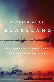
In the U.S., the focus is on California’s San Andreas fault, which geologists suggest has a nearly one-in-five chance of causing a major earthquake in the next three decades. But it’s not just the faults we know about that should concern us, says Kathryn Miles, author of Quakeland: On the Road to America’s Next Devastating Earthquake. As she explained when National Geographic caught up with her at her home in Portland, Maine, there’s a much larger number of faults we don’t know about—and fracking is only adding to the risks.
When it comes to earthquakes, there is really only one question everyone wants to know: When will the big one hit California?
That’s the question seismologists wish they could answer, too! One of the most shocking and surprising things for me is just how little is actually known about this natural phenomenon. The geophysicists, seismologists, aThe Sixth Seal Will be in New York (Revelation 6:12)nd emergency managers that I spoke with are the first to say, “We just don’t know!”
What we can say is that it is relatively certain that a major earthquake will happen in California in our lifetime. We don’t know where or when. An earthquake happening east of San Diego out in the desert is going to have hugely different effects than that same earthquake happening in, say, Los Angeles. They’re both possible, both likely, but we just don’t know.
One of the things that’s important to understand about San Andreas is that it’s a fault zone. As laypeople we tend to think about it as this single crack that runs through California and if it cracks enough it’s going to dump the state into the ocean. But that’s not what’s happening here. San Andreas is a huge fault zone, which goes through very different types of geological features. As a result, very different types of earthquakes can happen in different places.
As Charles Richter, inventor of the Richter Scale, famously said, “Only fools, liars and charlatans predict earthquakes.” Why are earthquakes so hard to predict? After all, we have sent rockets into space and plumbed the depths of the ocean.
You’re right: We know far more about distant galaxies than we do about the inner workings of our planet. The problem is that seismologists can’t study an earthquake because they don’t know when or where it’s going to happen. It could happen six miles underground or six miles under the ocean, in which case they can’t even witness it. They can go back and do forensic, post-mortem work. But we still don’t know where most faults lie. We only know where a fault is after an earthquake has occurred. If you look at the last 100 years of major earthquakes in the U.S., they’ve all happened on faults we didn’t even know existed.
Earthquakes 101
Earthquakes are unpredictable and can strike with enough force to bring buildings down. Find out what causes earthquakes, why they’re so deadly, and what’s being done to help buildings sustain their hits.
Fracking is a relatively new industry. Many people believe that it can cause what are known as induced earthquakes. What’s the scientific consensus?
The scientific consensus is that a practice known as wastewater injection undeniably causes earthquakes when the geological features are conducive. In the fracking process, water and lubricants are injected into the earth to split open the rock, so oil and natural gas can be retrieved. As this happens, wastewater is also retrieved and brought back to the surface.
You Might Also Like
Different states deal with this in different ways. Some states, like Pennsylvania, favor letting the wastewater settle in aboveground pools, which can cause run-off contamination of drinking supplies. Other states, like Oklahoma, have chosen to re-inject the water into the ground. And what we’re seeing in Oklahoma is that this injection is enough to shift the pressure inside the earth’s core, so that daily earthquakes are happening in communities like Stillwater. As our technology improves, and both our ability and need to extract more resources from the earth increases, our risk of causing earthquakes will also rise exponentially.
After Fukushima, the idea of storing nuclear waste underground cannot be guaranteed to be safe. Yet President Trump has recently green-lighted new funds for the Yucca Mountain site in Nevada. Is that wise?
The issue with Fukushima was not about underground nuclear storage but it is relevant. The Tohoku earthquake, off the coast of Japan, was a massive, 9.0 earthquake—so big that it shifted the axis of the earth and moved the entire island of Japan some eight centimeters! It also created a series of tsunamis, which swamped the Fukushima nuclear power plant to a degree the designers did not believe was possible.
Here in the U.S., we have nuclear plants that are also potentially vulnerable to earthquakes and tsunamis, above all on the East Coast, like Pilgrim Nuclear, south of Boston, or Indian Point, north of New York City. Both of these have been deemed by the USGS to have an unacceptable level of seismic risk. [Both are scheduled to close in the next few years.]
Yucca Mountain is meant to address our need to store the huge amounts of nuclear waste that have been accumulating for more than 40 years. Problem number one is getting it out of these plants. We are going to have to somehow truck or train these spent fuel rods from, say, Boston, to a place like Yucca Mountain, in Nevada. On the way it will have to go through multiple earthquake zones, including New Madrid, which is widely considered to be one of the country’s most dangerous earthquake zones.
Yucca Mountain itself has had seismic activity. Ultimately, there’s no great place to put nuclear waste—and there’s no guarantee that where we do put it is going to be safe.
The psychological and emotional effects of an earthquake are especially harrowing. Why is that?
This is a fascinating and newly emerging subfield within psychology, which looks at the effects of natural disasters on both our individual and collective psyches. Whenever you experience significant trauma, you’re going to see a huge increase in PTSD, anxiety, depression, suicide, and even violent behaviors.
What seems to make earthquakes particularly pernicious is the surprise factor. A tornado will usually give people a few minutes, if not longer, to prepare; same thing with hurricanes. But that doesn’t happen with an earthquake. There is nothing but profound surprise. And the idea that the bedrock we walk and sleep upon can somehow become liquid and mobile seems to be really difficult for us to get our heads around.
Psychologists think that there are two things happening. One is a PTSD-type loop where our brain replays the trauma again and again, manifesting itself in dreams or panic attacks during the day. But there also appears to be a physiological effect as well as a psychological one. If your readers have ever been at sea for some time and then get off the ship and try to walk on dry land, they know they will look like drunkards. [Laughs] The reason for this is that the inner ear has habituated itself to the motion of the ship. We think the inner ear does something similar in the case of earthquakes, in an attempt to make sense of this strange, jarring movement.
After the Abruzzo quake in Italy, seven seismologists were actually tried and sentenced to six years in jail for failing to predict the disaster. Wouldn’t a similar threat help improve the prediction skills of American seismologists?
[Laughs] The scientific community was uniform in denouncing that action by the Italian government because, right now, earthquakes are impossible to predict. But the question of culpability is an important one. To what degree do we want to hold anyone responsible? Do we want to hold the local meteorologist responsible if he gets the weather forecast wrong? [Laughs]
What scientists say—and I don’t think this is a dodge on their parts—is, “Predicting earthquakes is the Holy Grail; it’s not going to happen in our lifetime. It may never happen.” What we can do is work on early warning systems, where we can at least give people 30 or 90 seconds to make a few quick decisive moves that could well save your life. We have failed to do that. But Mexico has had one in place for years!
There is some evidence that animals can predict earthquakes. Is there any truth to these theories?
All we know right now is anecdotal information because this is so hard to test for. We don’t know where the next earthquake is going to be so we can’t necessarily set up cameras and observe the animals there. So we have to rely on these anecdotal reports, say, of reptiles coming out of the ground prior to a quake. The one thing that was recorded here in the U.S. recently was that in the seconds before an earthquake in Oklahoma huge flocks of birds took flight. Was that coincidence? Related? We can’t draw that correlation yet.
One of the fascinating new approaches to prediction is the MyQuake app. Tell us how it works—and why it could be an especially good solution for Third World countries.
The USGS desperately wants to have it funded. The reluctance appears to be from Congress. A consortium of universities, in conjunction with the USGS, has been working on some fascinating tools. One is a dense network of seismographs that feed into a mainframe computer, which can take all the information and within nanoseconds understand that an earthquake is starting.
MyQuake is an app where you can get up to date information on what’s happening around the world. What’s fascinating is that our phones can also serve as seismographs. The same technology that knows which way your phone is facing, and whether it should show us an image in portrait or landscape, registers other kinds of movement. Scientists at UC Berkeley are looking to see if they can crowd source that information so that in places where we don’t have a lot of seismographs or measuring instruments, like New York City or Chicago or developing countries like Nepal, we can use smart phones both to record quakes and to send out early warning notices to people.
You traveled all over the U.S. for your research. Did you return home feeling safer?
I do not feel safer in the sense that I had no idea just how much risk regions of this country face on a daily basis when it comes to seismic hazards. We tend to think of this as a West Coast problem but it’s not! It’s a New York, Memphis, Seattle, or Phoenix problem. Nearly every major urban center in this country is at risk of a measurable earthquake.
What I do feel safer about is knowing what I can do as an individual. I hope that is a major take-home message for people who read the book. There are so many things we should be doing as individuals, family members, or communities to minimize this risk: simple things from having a go-bag and an emergency plan amongst the family to larger things like building codes.
We know that a major earthquake is going to happen. It’s probably going to knock out our communications lines. Phones aren’t going to work, Wi-Fi is going to go down, first responders are not going to be able to get to people for quite some time. So it is beholden on all of us to make sure we can survive until help can get to us.
This interview was edited for length and clarity.

Friday, July 24, 2026

The Next Major Quake: The Sixth Seal of NYC


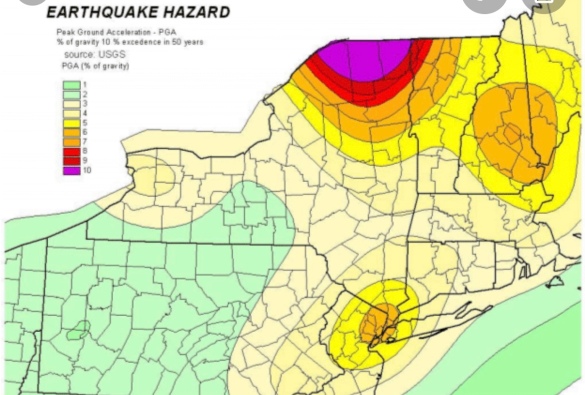
A recent assessment by the USGS determined that the earthquake hazard along the East Coast may previously have been underestimated. The varying risks around the US can be seen above, with New York City in the mid-range (yellow)

New York is OVERDUE an earthquake from a ‚brittle grid‘ of faults under the city, expert warns

  • New York City last experienced a M5 or higher earthquake in 1884, experts say
  • It’s thought that these earthquakes occur on a roughly 150-year periodicity 
  • Based on this, some say the city could be overdue for the next major quake 
Published: 15:50 EDT, 1 September 2017 | Updated: 12:00 EDT, 2 September 2017
When you think of the impending earthquake risk in the United States, it’s likely California or the Pacific Northwest comes to mind.
But, experts warn a system of faults making up a ‘brittle grid’ beneath New York City could also be loading up for a massive temblor.
The city has been hit by major quakes in the past, along what’s thought to be roughly 150-year intervals, and researchers investigating these faults now say the region could be overdue for the next event.
Experts warn a system of faults making up a ‘brittle grid’ beneath New York City could also be loading up for a massive temblor. The city has been hit by major quakes in the past, along what’s thought to be roughly 150-year intervals. A stock image is pictured

THE ‚CONEY ISLAND EARTHQUAKE‘

On August 10, 1884, New York was struck by a magnitude 5.5 earthquake with an epicentre located in Brooklyn.
While there was little damage and few injuries reported, anecdotal accounts of the event reveal the frightening effects of the quake.
One newspaper even reported that it caused someone to die from fright.
According to a New York Times report following the quake, massive buildings, including the Post Office swayed back and forth.
And, police said they felt the Brooklyn Bridge swaying ‘as if struck by a hurricane,’ according to an adaptation of Kathryn Miles’ book Quakeland: On the Road to America’s Next Devastating Earthquake.
The rumbles were felt across a 70,000-square-mile area, causing broken windows and cracked walls as far as Pennsylvania and Connecticut.
The city hasn’t experienced an earthquake this strong since.
According to geologist Dr Charles Merguerian, who has walked the entirety of Manhattan to assess its seismicity, there are a slew of faults running through New York, reports author Kathryn Miles in an adaptation of her new book Quakeland: On the Road to America’s Next Devastating Earthquake.
One such fault passes through 125th street, otherwise known as the Manhattanville Fault.
While there have been smaller quakes in New York’s recent past, including a magnitude 2.6 that struck in October 2001, it’s been decades since the last major tremor of M 5 or more.
And, most worryingly, the expert says there’s no way to predict exactly when a quake will strike.
‘That’s a question you really can’t answer,’ Merguerian has explained in the past.
‘All we can do is look at the record, and the record is that there was a relatively large earthquake here in the city in 1737, and in 1884, and that periodicity is about 150 year heat cycle.
‘So you have 1737, 1884, 20- and, we’re getting there. But statistics can lie.
‘An earthquake could happen any day, or it couldn’t happen for 100 years, and you just don’t know, there’s no way to predict.’
Compared the other parts of the United States, the risk of an earthquake in New York may not seem as pressing.
But, experts explain that a quake could happen anywhere.
According to geologist Dr Charles Merguerian, there are a slew of faults running through NY. One is the Ramapo Fault
‘All states have some potential for damaging earthquake shaking,’ according to the US Geological Survey.
‘Hazard is especially high along the west coast but also in the intermountain west, and in parts of the central and eastern US.’
A recent assessment by the USGS determined that the earthquake hazard along the East Coast may previously have been underestimated.
‘The eastern U.S. has the potential for larger and more damaging earthquakes than considered in previous maps and assessments,’ the USGS report explained.
The experts point to a recent example – the magnitude 5.8 earthquake that hit Virginia in 2011, which was among the largest to occur on the east coast in the last century.
This event suggests the area could be subjected to even larger earthquakes, even raising the risk for Charleston, SC.
It also indicates that New York City may be at higher risk than once thought.
A recent assessment by the USGS determined that the earthquake hazard along the East Coast may previously have been underestimated. The varying risks around the US can be seen above, with New York City in the mid-range (yellow).

Wednesday, July 22, 2026

The Next Major Quake: The Sixth Seal of NYC: Revelation 6


A recent assessment by the USGS determined that the earthquake hazard along the East Coast may previously have been underestimated. The varying risks around the US can be seen above, with New York City in the mid-range (yellow)

New York is OVERDUE an earthquake from a ‚brittle grid‘ of faults under the city, expert warns

  • New York City last experienced a M5 or higher earthquake in 1884, experts say
  • It’s thought that these earthquakes occur on a roughly 150-year periodicity 
  • Based on this, some say the city could be overdue for the next major quake 
Published: 15:50 EDT, 1 September 2017 | Updated: 12:00 EDT, 2 September 2017
When you think of the impending earthquake risk in the United States, it’s likely California or the Pacific Northwest comes to mind.
But, experts warn a system of faults making up a ‘brittle grid’ beneath New York City could also be loading up for a massive temblor.
The city has been hit by major quakes in the past, along what’s thought to be roughly 150-year intervals, and researchers investigating these faults now say the region could be overdue for the next event.
Experts warn a system of faults making up a ‘brittle grid’ beneath New York City could also be loading up for a massive temblor. The city has been hit by major quakes in the past, along what’s thought to be roughly 150-year intervals. A stock image is pictured

THE ‚CONEY ISLAND EARTHQUAKE‘

On August 10, 1884, New York was struck by a magnitude 5.5 earthquake with an epicentre located in Brooklyn.
While there was little damage and few injuries reported, anecdotal accounts of the event reveal the frightening effects of the quake.
One newspaper even reported that it caused someone to die from fright.
According to a New York Times report following the quake, massive buildings, including the Post Office swayed back and forth.
And, police said they felt the Brooklyn Bridge swaying ‘as if struck by a hurricane,’ according to an adaptation of Kathryn Miles’ book Quakeland: On the Road to America’s Next Devastating Earthquake.
The rumbles were felt across a 70,000-square-mile area, causing broken windows and cracked walls as far as Pennsylvania and Connecticut.
The city hasn’t experienced an earthquake this strong since.
According to geologist Dr Charles Merguerian, who has walked the entirety of Manhattan to assess its seismicity, there are a slew of faults running through New York, reports author Kathryn Miles in an adaptation of her new book Quakeland: On the Road to America’s Next Devastating Earthquake.
One such fault passes through 125th street, otherwise known as the Manhattanville Fault.
While there have been smaller quakes in New York’s recent past, including a magnitude 2.6 that struck in October 2001, it’s been decades since the last major tremor of M 5 or more.
And, most worryingly, the expert says there’s no way to predict exactly when a quake will strike.
‘That’s a question you really can’t answer,’ Merguerian has explained in the past.
‘All we can do is look at the record, and the record is that there was a relatively large earthquake here in the city in 1737, and in 1884, and that periodicity is about 150 year heat cycle.
‘So you have 1737, 1884, 20- and, we’re getting there. But statistics can lie.
‘An earthquake could happen any day, or it couldn’t happen for 100 years, and you just don’t know, there’s no way to predict.’
Compared the other parts of the United States, the risk of an earthquake in New York may not seem as pressing.
But, experts explain that a quake could happen anywhere.
According to geologist Dr Charles Merguerian, there are a slew of faults running through NY. One is the Ramapo Fault
‘All states have some potential for damaging earthquake shaking,’ according to the US Geological Survey.
‘Hazard is especially high along the west coast but also in the intermountain west, and in parts of the central and eastern US.’
A recent assessment by the USGS determined that the earthquake hazard along the East Coast may previously have been underestimated.
‘The eastern U.S. has the potential for larger and more damaging earthquakes than considered in previous maps and assessments,’ the USGS report explained.
The experts point to a recent example – the magnitude 5.8 earthquake that hit Virginia in 2011, which was among the largest to occur on the east coast in the last century.
This event suggests the area could be subjected to even larger earthquakes, even raising the risk for Charleston, SC.
It also indicates that New York City may be at higher risk than once thought.
A recent assessment by the USGS determined that the earthquake hazard along the East Coast may previously have been underestimated. The varying risks around the US can be seen above, with New York City in the mid-range (yellow).

Tuesday, July 21, 2026

The Trend Leading to the Sixth Seal (Revelation 6:12)


HOPKINS
January 14, 2020
Are we seeing a trend? After two small earthquakes hit upstate New York on January 3 and January 7, a slightly larger one was felt near the New York-Canadian border early Monday morning. And while the quake actually happened in an entirely different country, the effects were felt far south into New York state, and the surrounding region.
The United States Geological Survey says the 3.3 magnitude quake hit several mikes south of the town of Ormstown, Quebec a little after 5:30 A.M. There are some slightly conflicting reports, as the Montreal Gazette reports that the quake was a 3.6 magnitude. Ormstown is located around 20 minutes north of the New York border.
The Times Union says the quake was felt as far south as the town of Ticonderoga in Essex County, and as far west as the city of Ogdensburg on the New York-Ontario border. The effects were also felt as far north as Montreal.
No damage was reported.
Yes, earthquakes do happen in the northeastern U.S and Canada occasionally. In December 2019, a 2.1 tremor was reported near Sodus Point, off the coast of Lake Ontario.
Some strike even closer to home. In April 2017, a 1.3 tremor occurred around two and half miles west of Pawling. In early 2016, an even smaller quake happened near Port Chester and Greenwich, CT. In the summer of 2019, a quake struck off the New Jersey coast.
On August 23, 2011, a 5.8 quake, that was centered in Virginia, was felt all the way up the east coast. Several moderate (at least a 5 on the richter scale) quakes have occurred near New York City in 1737, 1783 and 1884.
Listen to Middays With Hopkins weekdays from 10AM to 2PM on 101.5 WPDH. Stream us live through the website, Alexa-enabled device, Google Home or the WPDH mobile app.