Sunday, October 8, 2023

New York Subways at the Sixth Seal (Revelation 6)

                  How vulnerable are NYC’s underwater subway tunnels to flooding?

Ashley Fetters
New York City is full of peculiar phenomena—rickety fire escapes; 100-year-old subway tunnels; air conditioners propped perilously into window frames—that can strike fear into the heart of even the toughest city denizen. But should they? Every month, writer Ashley Fetters will be exploring—and debunking—these New York-specific fears, letting you know what you should actually worry about, and what anxieties you can simply let slip away.
The 25-minute subway commute from Crown Heights to the Financial District on the 2/3 line is, in my experience, a surprisingly peaceful start to the workday—save for one 3,100-foot stretch between the Clark Street and Wall Street stations, where for three minutes I sit wondering what the probability is that I will soon die a torturous, claustrophobic drowning death right here in this subway car.
The Clark Street Tunnel, opened in 1916, is one of approximately a dozen tunnels that escort MTA passengers from one borough to the next underwater—and just about all of them, with the exception of the 1989 addition of the 63rd Street F train tunnel, were constructed between 1900 and 1936.
Each day, thousands of New Yorkers venture across the East River and back again through these tubes buried deep in the riverbed, some of which are nearing or even past their 100th birthdays. Are they wrong to ponder their own mortality while picturing one of these watery catacombs suddenly springing a leak?
Mostly yes, they are, says Michael Horodniceanu, the former president of MTA Capital Construction and current principal of Urban Advisory Group. First, it’s important to remember that the subway tunnel is built under the riverbed, not just in the river—so what immediately surrounds the tunnel isn’t water but some 25 feet of soil. “There’s a lot of dirt on top of it,” Horodniceanu says. “It’s well into the bed of the bottom of the channel.”
And second, as Angus Kress Gillespie, author of Crossing Under the Hudson: The Story of the Holland and Lincoln Tunnels, points out, New York’s underwater subway tunnels are designed to withstand some leaking. And withstand it they do: Pumps placed below the floor of the tunnel, he says, are always running, always diverting water seepage into the sewers. (Horodniceanu says the amount of water these pumps divert into the sewer system each day numbers in the thousands of gallons.)
Additionally, MTA crews routinely repair the grouting and caulking, and often inject a substance into the walls that creates a waterproof membrane outside the tunnel—which keeps water out of the tunnel and relieves any water pressure acting on its walls. New tunnels, Horodniceanu points out, are even built with an outside waterproofing membrane that works like an umbrella: Water goes around it, it falls to the sides, and then it gets channeled into a pumping station and pumped out.
Of course, the classic New York nightmare scenario isn’t just a cute little trickle finding its way in. The anxiety daydream usually involves something sinister, or seismic. The good news, however, is that while an earthquake or explosion would indeed be bad for many reasons, it likely wouldn’t result in the frantic flooding horror scene that plays out in some commuters’ imaginations.
The Montague Tube, which sustained severe damage during Hurricane Sandy.
MTA New York City Transit / Marc A. Hermann
Horodniceanu assures me that tunnels built more recently are “built to withstand a seismic event.” The older tunnels, however—like, um, the Clark Street Tunnel—“were not seismically retrofitted, let me put it that way,” Horodniceanu says. “But the way they were built is in such a way that I do not believe an earthquake would affect them.” They aren’t deep enough in the ground, anyway, he says, to be too intensely affected by a seismic event. (The MTA did not respond to a request for comment.)
One of the only real threats to tunnel infrastructure, Horodniceanu adds, is extreme weather. Hurricane Sandy, for example, caused flooding in the tunnels, which “created problems with the infrastructure.” He continues, “The tunnels have to be rebuilt as a result of saltwater corroding the infrastructure.”
Still, he points out, hurricanes don’t exactly happen with no warning. So while Hurricane Sandy did cause major trauma to the tunnels, train traffic could be stopped with ample time to keep passengers out of harm’s way. In 2012, Governor Andrew Cuomo directed all the MTA’s mass transit services to shut down at 7 p.m. the night before Hurricane Sandy was expected to hit New York City.
And Gillespie, for his part, doubts even an explosion would result in sudden, dangerous flooding. A subway tunnel is not a closed system, he points out; it’s like a pipe that’s open at both ends. “The force of a blast would go forwards and backwards out the exit,” he says.
So the subway-train version of that terrifying Holland Tunnel flood scene in Sylvester Stallone’s Daylight is … unrealistic, right?
“Yeah,” Gillespie laughs. “Yeah. It is.”
Got a weird New York anxiety that you want explored? E-mail tips@curbed.com, and we may include it in a future column.

Friday, October 6, 2023

Columbia University Warns Of Sixth Seal (Revelation 6:12)


Earthquakes May Endanger New York More Than Thought, Says Study
A study by a group of prominent seismologists suggests that a pattern of subtle but active faults makes the risk of earthquakes to the New York City area substantially greater than formerly believed. Among other things, they say that the controversial Indian Point nuclear power plants, 24 miles north of the city, sit astride the previously unidentified intersection of two active seismic zones. The paper appears in the current issue of the Bulletin of the Seismological Society of America.
Many faults and a few mostly modest quakes have long been known around New York City, but the research casts them in a new light. The scientists say the insight comes from sophisticated analysis of past quakes, plus 34 years of new data on tremors, most of them perceptible only by modern seismic instruments. The evidence charts unseen but potentially powerful structures whose layout and dynamics are only now coming clearer, say the scientists. All are based at Columbia University’s Lamont-Doherty Earth Observatory, which runs the network of seismometers that monitors most of the northeastern United States.
Lead author Lynn R. Sykes said the data show that large quakes are infrequent around New Yorkcompared to more active areas like California and Japan, but that the risk is high, because of the overwhelming concentration of people and infrastructure. “The research raises the perception both of how common these events are, and, specifically, where they may occur,” he said. “It’s an extremely populated area with very large assets.” Sykes, who has studied the region for four decades, is known for his early role in establishing the global theory of plate tectonics.
The authors compiled a catalog of all 383 known earthquakes from 1677 to 2007 in a 15,000-square-mile area around New York City. Coauthor John Armbruster estimated sizes and locations of dozens of events before 1930 by combing newspaper accounts and other records. The researchers say magnitude 5 quakes—strong enough to cause damage–occurred in 1737, 1783 and 1884. There was little settlement around to be hurt by the first two quakes, whose locations are vague due to a lack of good accounts; but the last, thought to be centered under the seabed somewhere between Brooklyn and Sandy Hook, toppled chimneys across the city and New Jersey, and panicked bathers at Coney Island. Based on this, the researchers say such quakes should be routinely expected, on average, about every 100 years. “Today, with so many more buildings and people, a magnitude 5 centered below the city would be extremely attention-getting,” said Armbruster. “We’d see billions in damage, with some brick buildings falling. People would probably be killed.”
Starting in the early 1970s Lamont began collecting data on quakes from dozens of newly deployed seismometers; these have revealed further potential, including distinct zones where earthquakes concentrate, and where larger ones could come. The Lamont network, now led by coauthor Won-Young Kim, has located hundreds of small events, including a magnitude 3 every few years, which can be felt by people at the surface, but is unlikely to cause damage. These small quakes tend to cluster along a series of small, old faults in harder rocks across the region. Many of the faults were discovered decades ago when subways, water tunnels and other excavations intersected them, but conventional wisdom said they were inactive remnants of continental collisions and rifting hundreds of millions of years ago. The results clearly show that they are active, and quite capable of generating damaging quakes, said Sykes.
One major previously known feature, the Ramapo Seismic Zone, runs from eastern Pennsylvania to the mid-Hudson Valley, passing within a mile or two northwest of Indian Point. The researchers found that this system is not so much a single fracture as a braid of smaller ones, where quakes emanate from a set of still ill-defined faults. East and south of the Ramapo zone—and possibly more significant in terms of hazard–is a set of nearly parallel northwest-southeast faults. These include Manhattan’s 125th Street fault, which seems to have generated two small 1981 quakes, and could have been the source of the big 1737 quake; the Dyckman Street fault, which carried a magnitude 2 in 1989; the Mosholu Parkway fault; and the Dobbs Ferry fault in suburban Westchester, which generated the largest recent shock, a surprising magnitude 4.1, in 1985. Fortunately, it did no damage. Given the pattern, Sykes says the big 1884 quake may have hit on a yet-undetected member of this parallel family further south.
The researchers say that frequent small quakes occur in predictable ratios to larger ones, and so can be used to project a rough time scale for damaging events. Based on the lengths of the faults, the detected tremors, and calculations of how stresses build in the crust, the researchers say that magnitude 6 quakes, or even 7—respectively 10 and 100 times bigger than magnitude 5–are quite possible on the active faults they describe. They calculate that magnitude 6 quakes take place in the area about every 670 years, and sevens, every 3,400 years. The corresponding probabilities of occurrence in any 50-year period would be 7% and 1.5%. After less specific hints of these possibilities appeared in previous research, a 2003 analysis by The New York City Area Consortium for Earthquake Loss Mitigation put the cost of quakes this size in the metro New York area at $39 billion to $197 billion. A separate 2001 analysis for northern New Jersey’s Bergen County estimates that a magnitude 7 would destroy 14,000 buildings and damage 180,000 in that area alone. The researchers point out that no one knows when the last such events occurred, and say no one can predict when they next might come.
“We need to step backward from the simple old model, where you worry about one large, obvious fault, like they do in California,” said coauthor Leonardo Seeber. “The problem here comes from many subtle faults. We now see there is earthquake activity on them. Each one is small, but when you add them up, they are probably more dangerous than we thought. We need to take a very close look.” Seeber says that because the faults are mostly invisible at the surface and move infrequently, a big quake could easily hit one not yet identified. “The probability is not zero, and the damage could be great,” he said. “It could be like something out of a Greek myth.”
The researchers found concrete evidence for one significant previously unknown structure: an active seismic zone running at least 25 miles from Stamford, Conn., to the Hudson Valley town of Peekskill, N.Y., where it passes less than a mile north of the Indian Point nuclear power plant. The Stamford-Peekskill line stands out sharply on the researchers’ earthquake map, with small events clustered along its length, and to its immediate southwest. Just to the north, there are no quakes, indicating that it represents some kind of underground boundary. It is parallel to the other faults beginning at 125th Street, so the researchers believe it is a fault in the same family. Like the others, they say it is probably capable of producing at least a magnitude 6 quake. Furthermore, a mile or so on, it intersects the Ramapo seismic zone.
Sykes said the existence of the Stamford-Peekskill line had been suggested before, because the Hudson takes a sudden unexplained bend just ot the north of Indian Point, and definite traces of an old fault can be along the north side of the bend. The seismic evidence confirms it, he said. “Indian Point is situated at the intersection of the two most striking linear features marking the seismicity and also in the midst of a large population that is at risk in case of an accident,” says the paper. “This is clearly one of the least favorable sites in our study area from an earthquake hazard and risk perspective.”
The findings comes at a time when Entergy, the owner of Indian Point, is trying to relicense the two operating plants for an additional 20 years—a move being fought by surrounding communities and the New York State Attorney General. Last fall the attorney general, alerted to the then-unpublished Lamont data, told a Nuclear Regulatory Commission panel in a filing: “New data developed in the last 20 years disclose a substantially higher likelihood of significant earthquake activity in the vicinity of [Indian Point] that could exceed the earthquake design for the facility.” The state alleges that Entergy has not presented new data on earthquakes past 1979. However, in a little-noticed decision this July 31, the panel rejected the argument on procedural grounds. A source at the attorney general’s office said the state is considering its options.
The characteristics of New York’s geology and human footprint may increase the problem. Unlike in California, many New York quakes occur near the surface—in the upper mile or so—and they occur not in the broken-up, more malleable formations common where quakes are frequent, but rather in the extremely hard, rigid rocks underlying Manhattan and much of the lower Hudson Valley. Such rocks can build large stresses, then suddenly and efficiently transmit energy over long distances. “It’s like putting a hard rock in a vise,” said Seeber. “Nothing happens for a while. Then it goes with a bang.” Earthquake-resistant building codes were not introduced to New York City until 1995, and are not in effect at all in many other communities. Sinuous skyscrapers and bridges might get by with minimal damage, said Sykes, but many older, unreinforced three- to six-story brick buildings could crumble.
Art Lerner-Lam, associate director of Lamont for seismology, geology and tectonophysics, pointed out that the region’s major highways including the New York State Thruway, commuter and long-distance rail lines, and the main gas, oil and power transmission lines all cross the parallel active faults, making them particularly vulnerable to being cut. Lerner-Lam, who was not involved in the research, said that the identification of the seismic line near Indian Point “is a major substantiation of a feature that bears on the long-term earthquake risk of the northeastern United States.” He called for policymakers to develop more information on the region’s vulnerability, to take a closer look at land use and development, and to make investments to strengthen critical infrastructure.
“This is a landmark study in many ways,” said Lerner-Lam. “It gives us the best possible evidence that we have an earthquake hazard here that should be a factor in any planning decision. It crystallizes the argument that this hazard is not random. There is a structure to the location and timing of the earthquakes. This enables us to contemplate risk in an entirely different way. And since we are able to do that, we should be required to do that.”
New York Earthquake Briefs and Quotes:
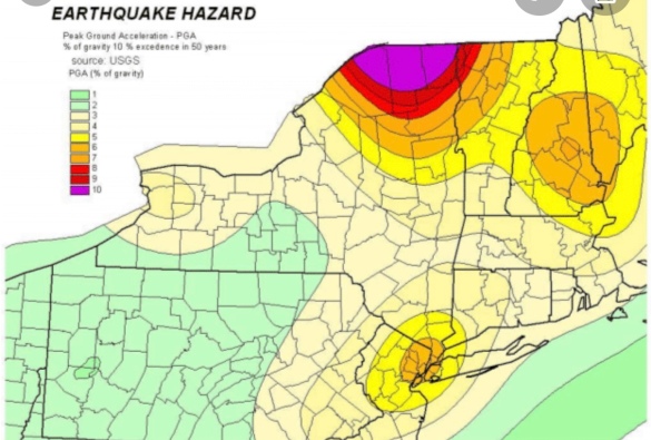
Existing U.S. Geological Survey seismic hazard maps show New York City as facing more hazard than many other eastern U.S. areas. Three areas are somewhat more active—northernmost New York State, New Hampshire and South Carolina—but they have much lower populations and fewer structures. The wider forces at work include pressure exerted from continuing expansion of the mid-Atlantic Ridge thousands of miles to the east; slow westward migration of the North American continent; and the area’s intricate labyrinth of old faults, sutures and zones of weakness caused by past collisions and rifting.
Due to New York’s past history, population density and fragile, interdependent infrastructure, a 2001 analysis by the Federal Emergency Management Agency ranks it the 11th most at-risk U.S. city for earthquake damage. Among those ahead: Los Angeles, San Francisco, Seattle and Portland. Behind: Salt Lake City, Sacramento, Anchorage.
New York’s first seismic station was set up at Fordham University in the 1920s. Lamont-Doherty Earth Observatory, in Palisades, N.Y., has operated stations since 1949, and now coordinates a network of about 40.
Dozens of small quakes have been felt in the New York area. A Jan. 17, 2001 magnitude 2.4, centered  in the Upper East Side—the first ever detected in Manhattan itself–may have originated on the 125th Street fault. Some people thought it was an explosion, but no one was harmed.
The most recent felt quake, a magnitude 2.1 on July 28, 2008, was centered near Milford, N.J. Houses shook and a woman at St. Edward’s Church said she felt the building rise up under her feet—but no damage was done.
Questions about the seismic safety of the Indian Point nuclear power plant, which lies amid a metropolitan area of more than 20 million people, were raised in previous scientific papers in 1978 and 1985.
Because the hard rocks under much of New York can build up a lot strain before breaking, researchers believe that modest faults as short as 1 to 10 kilometers can cause magnitude 5 or 6 quakes.
In general, magnitude 3 quakes occur about 10 times more often than magnitude fours; 100 times more than magnitude fives; and so on. This principle is called the Gutenberg-Richter relationship.

Thursday, October 5, 2023

The History Of New York Earthquakes: Before The Sixth Seal (Revelation 6:12)


Historic Earthquakes
Near New York City, New York
1884 08 10 19:07 UTC
Magnitude 5.5The History Of New York Earthquakes: Before The Sixth Seal (Rev 6:12)
Intensity VII
USGS.gov
This severe earthquake affected an area roughly extending along the Atlantic Coast from southern Maine to central Virginia and westward to Cleveland, Ohio. Chimneys were knocked down and walls were cracked in several States, including Connecticut, New Jersey, New York, and Pennsylvania. Many towns from Hartford, Connecticut, to West Chester,Pennsylvania.
Property damage was severe at Amityville and Jamaica, New York, where several chimneys were “overturned” and large cracks formed in walls. Two chimneys were thrown down and bricks were shaken from other chimneys at Stratford (Fairfield County), Conn.; water in the Housatonic River was agitated violently. At Bloomfield, N.J., and Chester, Pa., several chimneys were downed and crockery was broken. Chimneys also were damaged at Mount Vernon, N.Y., and Allentown, Easton, and Philadelphia, Pa. Three shocks occurred, the second of which was most violent. This earthquake also was reported felt in Vermont, Virginia, and Washington, D.C. Several slight aftershocks were reported on August 11.
Teilen mit:
TwitterFacebook

Wednesday, October 4, 2023

A Lack Of Vigilance Before The Sixth Seal (Revelation 6:12)

                Faults Underlying Exercise Vigilant Guard

Story by: (Author NameStaff Sgt. Raymond Drumsta – 138th Public Affairs Detachment
Dated: Thu, Nov 5, 2009
This map illustrates the earthquake fault lines in Western New York. An earthquake in the region is a likely event, says University of Buffalo Professor Dr. Robert Jacobi.
TONAWANDA, NY — An earthquake in western New York, the scenario that Exercise Vigilant Guard is built around, is not that far-fetched, according to University of Buffalo geology professor Dr. Robert Jacobi.
When asked about earthquakes in the area, Jacobi pulls out a computer-generated state map, cross-hatched with diagonal lines representing geological faults.
The faults show that past earthquakes in the state were not random, and could occur again on the same fault systems, he said.
“In western New York, 6.5 magnitude earthquakes are possible,” he said.
This possibility underlies Exercise Vigilant Guard, a joint training opportunity for National Guard and emergency response organizations to build relationships with local, state, regional and federal partners against a variety of different homeland security threats including natural disasters and potential terrorist attacks.
The exercise was based on an earthquake scenario, and a rubble pile at the Spaulding Fibre site here was used to simulate a collapsed building. The scenario was chosen as a result of extensive consultations with the earthquake experts at the University of Buffalo’s Multidisciplinary Center for Earthquake Engineering Research (MCEER), said Brig. Gen. Mike Swezey, commander of 53rd Troop Command, who visited the site on Monday.
Earthquakes of up to 7 magnitude have occurred in the Northeastern part of the continent, and this scenario was calibrated on the magnitude 5.9 earthquake which occurred in Saguenay, Quebec in 1988, said Jacobi and Professor Andre Filiatrault, MCEER director.
“A 5.9 magnitude earthquake in this area is not an unrealistic scenario,” said Filiatrault.
Closer to home, a 1.9 magnitude earthquake occurred about 2.5 miles from the Spaulding Fibre site within the last decade, Jacobi said. He and other earthquake experts impaneled by the Atomic Energy Control Board of Canada in 1997 found that there’s a 40 percent chance of 6.5 magnitude earthquake occurring along the Clareden-Linden fault system, which lies about halfway between Buffalo and Rochester, Jacobi added.
Jacobi and Filiatrault said the soft soil of western New York, especially in part of downtown Buffalo, would amplify tremors, causing more damage.
“It’s like jello in a bowl,” said Jacobi.
The area’s old infrastructure is vulnerable because it was built without reinforcing steel, said Filiatrault. Damage to industrial areas could release hazardous materials, he added.
“You’ll have significant damage,” Filiatrault said.
Exercise Vigilant Guard involved an earthquake’s aftermath, including infrastructure damage, injuries, deaths, displaced citizens and hazardous material incidents. All this week, more than 1,300 National Guard troops and hundreds of local and regional emergency response professionals have been training at several sites in western New York to respond these types of incidents.
Jacobi called Exercise Vigilant Guard “important and illuminating.”
“I’m proud of the National Guard for organizing and carrying out such an excellent exercise,” he said.
Training concluded Thursday.

Tuesday, October 3, 2023

The Trend Leading to the Sixth Seal (Revelation 6:12)


HOPKINS
January 14, 2020
Are we seeing a trend? After two small earthquakes hit upstate New York on January 3 and January 7, a slightly larger one was felt near the New York-Canadian border early Monday morning. And while the quake actually happened in an entirely different country, the effects were felt far south into New York state, and the surrounding region.
The United States Geological Survey says the 3.3 magnitude quake hit several mikes south of the town of Ormstown, Quebec a little after 5:30 A.M. There are some slightly conflicting reports, as the Montreal Gazette reports that the quake was a 3.6 magnitude. Ormstown is located around 20 minutes north of the New York border.
The Times Union says the quake was felt as far south as the town of Ticonderoga in Essex County, and as far west as the city of Ogdensburg on the New York-Ontario border. The effects were also felt as far north as Montreal.
No damage was reported.
Yes, earthquakes do happen in the northeastern U.S and Canada occasionally. In December 2019, a 2.1 tremor was reported near Sodus Point, off the coast of Lake Ontario.
Some strike even closer to home. In April 2017, a 1.3 tremor occurred around two and half miles west of Pawling. In early 2016, an even smaller quake happened near Port Chester and Greenwich, CT. In the summer of 2019, a quake struck off the New Jersey coast.
On August 23, 2011, a 5.8 quake, that was centered in Virginia, was felt all the way up the east coast. Several moderate (at least a 5 on the richter scale) quakes have occurred near New York City in 1737, 1783 and 1884.
Listen to Middays With Hopkins weekdays from 10AM to 2PM on 101.5 WPDH. Stream us live through the website, Alexa-enabled device, Google Home or the WPDH mobile app.

Monday, October 2, 2023

Indian Point Pipeline is NOT Safe (Revelation 6:12)


In February 2016, New York Gov. Andrew Cuomo commissioned a study of the risks of running a gas pipeline through the Indian Point nuclear plant site. Seven months later, the state told the consulting firm preparing the $275,000 assessment to complete it by Dec. 31, 2016.
More than a year after that deadline, the study hasn’t been released and its status remains unclear. [Editor’s note: In June the state released the executive summary of the report.]
After repeated efforts to pry loose the document through Freedom of Information Law requests, activists are urging Cuomo and local officials to do something. Stop the Algonquin Pipeline Expansion (SAPE), formed as the pipeline plans took shape, is among the groups that will take part in an “interfaith climate vigil” for Feb. 25 outside Cuomo’s Mount Kisco home.
Known as the Algonquin Incremental Market (AIM) project, the 42-inch pipeline began operation in January 2017 despite opposition from environmentalists and scientists who argued that a high-pressure pipe cannot be safely snaked through 2,300 feet of a nuclear power complex, much less one, like Indian Point, in an earthquake fault.
Although Indian Point is scheduled to close by spring 2021, critics contend that dangers of a pipeline accident will remain because spent radioactive fuel will be stored at the facility indefinitely.
Constructed by Spectra Energy, AIM is a link in a system to carry natural gas from the Marcellus Shale formation in Pennsylvania into New York, beneath the Hudson River, and across Putnam County into Connecticut, Massachusetts and Rhode Island. The Federal Energy Regulatory Commission approved the pipeline, although critics contend that its decision was based on erroneous data.
On Feb. 1, Philipstown resident Paula Clair asked the Town Board to call for the study to be released, saying that “we who live close to the nuclear plant have a right to know” of the hazards. Clair, who sits on the town’s Zoning Board of Appeals, said that the proximity of the gas pipeline to spent nuclear fuel means that “if there was an explosion or a fire, it would be a catastrophe.”
A draft resolution she proposed noted that a radioactive release caused by an explosion could “render Philipstown uninhabitable for generations.”
Philipstown Supervisor Richard Shea agreed that the study, paid for with taxpayer funds, should be released, and promised that the board would consider passing a measure soon. “I don’t think it’s going to be a problem” approving it, he said.
Susan Van Dolsen, co-founder of SAPE, said her organization has been attempting to get a copy of the study through FOIL and other means since mid-2016, without success. Instead of the study, the state sent stacks of emails and other items, often of dubious relevance, she said, with large portions blacked out.
Sandy Galef, who represents Philipstown and Beacon in the state Assembly and serves on the task force looking at the impact of Indian Point’s closure, also wants the assessment released.
In a Jan. 19 letter to Cuomo, she reminded the governor that she had previously asked to see the document, which, she said, becomes especially important as the task force looks at possible re-uses of Indian Point after its nuclear operations cease. “I don’t think we can move forward without all possible information,” she wrote.
As of Thursday (Feb. 22), the governor’s office had not responded to questions posed a week earlier by The Current about the study. The state Office of General Services, which oversaw the contract for the study, on Feb. 14 referred inquiries to the state Division of Homeland Security and Emergency Services, which also did not respond.

History Warns New York Is The Sixth Seal (Revelation 6:12)


New York Earthquake 1884
Friday, 18 March 2011 – 9:23pm IST | Place: NEW YORK | Agency: ANI
If the past is any indication, New York can be hit by an earthquake, claims John Armbruster, a seismologist at Columbia University’s Lamont-Doherty Earth Observatory.Based on historical precedent, Armbruster says the New York City metro area is susceptible to an earthquake of at least a magnitude of 5.0 once a century.According to the New York Daily News, Lynn Skyes, lead author of a recent study by seismologists at the Lamont-Doherty Earth Observatory adds that a magnitude-6 quake hits the area about every 670 years, and magnitude-7 every 3,400 years.A 5.2-magnitude quake shook New York City in 1737 and another of the same severity hit in 1884.
Tremors were felt from Maine to Virginia.
“The problem here comes from many subtle faults,” explained Skyes after the study was published.
He adds: “We now see there is earthquake activity on them. Each one is small, but when you add them up, they are probably more dangerous than we thought.”
Armbruster says a 5.0-magnitude earthquake today likely would result in casualties and hundreds of millions of dollars in damage.
“I would expect some people to be killed,” he notes.
The scope and scale of damage would multiply exponentially with each additional tick on the Richter scale.