Wednesday, November 9, 2022

New York Earthquake: City of the Sixth Seal (Revelation 6:12)


New York earthquake: City at risk of ‚dangerous shaking from far away‘
Joshua Nevett
Published 30th April 2018
SOME of New York City’s tallest skyscrapers are at risk of being shaken by seismic waves triggered by powerful earthquakes from miles outside the city, a natural disaster expert has warned.
Researchers believe that a powerful earthquake, magnitude 5 or greater, could cause significant damage to large swathes of NYC, a densely populated area dominated by tall buildings.
A series of large fault lines that run underneath NYC’s five boroughs, Manhattan, Brooklyn, Queens, The Bronx and Staten Island, are capable of triggering large earthquakes.
Some experts have suggested that NYC is susceptible to at least a magnitude 5 earthquake once every 100 years.
The last major earthquake measuring over magnitude 5.0 struck NYC in 1884 – meaning another one of equal size is “overdue” by 34 years, according their prediction model.
Natural disaster researcher Simon Day, of University College London, agrees with the conclusion that NYC may be more at risk from earthquakes than is usually thought.
EARTHQUAKE RISK: New York is susceptible to seismic shaking from far-away tremors
But the idea of NYC being “overdue” for an earthquake is “invalid”, not least because the “very large number of faults” in the city have individually low rates of activity, he said.
The model that predicts strong earthquakes based on timescale and stress build-up on a given fault has been “discredited”, he said.
What scientists should be focusing on, he said, is the threat of large and potentially destructive earthquakes from “much greater distances”.
The dangerous effects of powerful earthquakes from further away should be an “important feature” of any seismic risk assessment of NYC, Dr Day said.

GETTY
THE BIG APPLE: An aerial view of Lower Manhattan at dusk in New York City
USGS
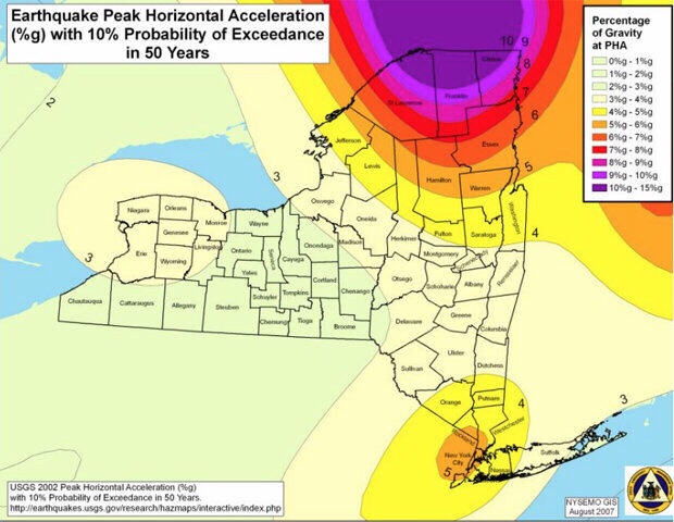
RISK: A seismic hazard map of New York produced by USGS
“New York is susceptible to seismic shaking from earthquakes at much greater distances” Dr Simon Day, natural disaster researcher
This is because the bedrock underneath parts of NYC, including Long Island and Staten Island, cannot effectively absorb the seismic waves produced by earthquakes.
“An important feature of the central and eastern United States is, because the crust there is old and cold, and contains few recent fractures that can absorb seismic waves, the rate of seismic reduction is low.
Central regions of NYC, including Manhattan, are built upon solid granite bedrock; therefore the amplification of seismic waves that can shake buildings is low.
But more peripheral areas, such as Staten Island and Long Island, are formed by weak sediments, meaning seismic hazard in these areas is “very likely to be higher”, Dr Day said.
“Thus, like other cities in the eastern US, New York is susceptible to seismic shaking from earthquakes at much greater distances than is the case for cities on plate boundaries such as Tokyo or San Francisco, where the crustal rocks are more fractured and absorb seismic waves more efficiently over long distances,” Dr Day said.
In the event of a large earthquake, dozens of skyscrapers, including Chrysler Building, the Woolworth Building and 40 Wall Street, could be at risk of shaking.
“The felt shaking in New York from the Virginia earthquake in 2011 is one example,” Dr Day said.
On that occasion, a magnitude 5.8 earthquake centered 340 miles south of New York sent thousands of people running out of swaying office buildings.

USGS
FISSURES: Fault lines in New York City have low rates of activity, Dr Day said
NYC Mayor Michael Bloomberg said the city was “lucky to avoid any major harm” as a result of the quake, whose epicenter was near Louisa, Virginia, about 40 miles from Richmond.
“But an even more impressive one is the felt shaking from the 1811-1812 New Madrid earthquakes in the central Mississippi valley, which was felt in many places across a region, including cities as far apart as Detroit, Washington DC and New Orleans, and in a few places even further afield including,” Dr Day added.
“So, if one was to attempt to do a proper seismic hazard assessment for NYC, one would have to include potential earthquake sources over a wide region, including at least the Appalachian mountains to the southwest and the St Lawrence valley to the north and east.”

Tuesday, November 8, 2022

New York Subways at the Sixth Seal (Revelation 6)

            How vulnerable are NYC’s underwater subway tunnels to flooding?

Ashley Fetters
New York City is full of peculiar phenomena—rickety fire escapes; 100-year-old subway tunnelsair conditioners propped perilously into window frames—that can strike fear into the heart of even the toughest city denizen. But should they? Every month, writer Ashley Fetters will be exploring—and debunking—these New York-specific fears, letting you know what you should actually worry about, and what anxieties you can simply let slip away.
The 25-minute subway commute from Crown Heights to the Financial District on the 2/3 line is, in my experience, a surprisingly peaceful start to the workday—save for one 3,100-foot stretch between the Clark Street and Wall Street stations, where for three minutes I sit wondering what the probability is that I will soon die a torturous, claustrophobic drowning death right here in this subway car.
The Clark Street Tunnel, opened in 1916, is one of approximately a dozen tunnels that escort MTA passengers from one borough to the next underwater—and just about all of them, with the exception of the 1989 addition of the 63rd Street F train tunnel, were constructed between 1900 and 1936.
Each day, thousands of New Yorkers venture across the East River and back again through these tubes buried deep in the riverbed, some of which are nearing or even past their 100th birthdays. Are they wrong to ponder their own mortality while picturing one of these watery catacombs suddenly springing a leak?
Mostly yes, they are, says Michael Horodniceanu, the former president of MTA Capital Construction and current principal of Urban Advisory Group. First, it’s important to remember that the subway tunnel is built under the riverbed, not just in the river—so what immediately surrounds the tunnel isn’t water but some 25 feet of soil. “There’s a lot of dirt on top of it,” Horodniceanu says. “It’s well into the bed of the bottom of the channel.”
And second, as Angus Kress Gillespie, author of Crossing Under the Hudson: The Story of the Holland and Lincoln Tunnels, points out, New York’s underwater subway tunnels are designed to withstand some leaking. And withstand it they do: Pumps placed below the floor of the tunnel, he says, are always running, always diverting water seepage into the sewers. (Horodniceanu says the amount of water these pumps divert into the sewer system each day numbers in the thousands of gallons.)
Additionally, MTA crews routinely repair the grouting and caulking, and often inject a substance into the walls that creates a waterproof membrane outside the tunnel—which keeps water out of the tunnel and relieves any water pressure acting on its walls. New tunnels, Horodniceanu points out, are even built with an outside waterproofing membrane that works like an umbrella: Water goes around it, it falls to the sides, and then it gets channeled into a pumping station and pumped out.
Of course, the classic New York nightmare scenario isn’t just a cute little trickle finding its way in. The anxiety daydream usually involves something sinister, or seismic. The good news, however, is that while an earthquake or explosion would indeed be bad for many reasons, it likely wouldn’t result in the frantic flooding horror scene that plays out in some commuters’ imaginations.
The Montague Tube, which sustained severe damage during Hurricane Sandy.
MTA New York City Transit / Marc A. Hermann
Horodniceanu assures me that tunnels built more recently are “built to withstand a seismic event.” The older tunnels, however—like, um, the Clark Street Tunnel—“were not seismically retrofitted, let me put it that way,” Horodniceanu says. “But the way they were built is in such a way that I do not believe an earthquake would affect them.” They aren’t deep enough in the ground, anyway, he says, to be too intensely affected by a seismic event. (The MTA did not respond to a request for comment.)
One of the only real threats to tunnel infrastructure, Horodniceanu adds, is extreme weather. Hurricane Sandy, for example, caused flooding in the tunnels, which “created problems with the infrastructure.” He continues, “The tunnels have to be rebuilt as a result of saltwater corroding the infrastructure.”
Still, he points out, hurricanes don’t exactly happen with no warning. So while Hurricane Sandy did cause major trauma to the tunnels, train traffic could be stopped with ample time to keep passengers out of harm’s way. In 2012, Governor Andrew Cuomo directed all the MTA’s mass transit services to shut down at 7 p.m. the night before Hurricane Sandy was expected to hit New York City.
And Gillespie, for his part, doubts even an explosion would result in sudden, dangerous flooding. A subway tunnel is not a closed system, he points out; it’s like a pipe that’s open at both ends. “The force of a blast would go forwards and backwards out the exit,” he says.
So the subway-train version of that terrifying Holland Tunnel flood scene in Sylvester Stallone’s Daylight is … unrealistic, right?
“Yeah,” Gillespie laughs. “Yeah. It is.”
Got a weird New York anxiety that you want explored? E-mail tips@curbed.com, and we may include it in a future column.

A Lack Of Vigilance Before The Sixth Seal (Revelation 6:12)

           Faults Underlying Exercise Vigilant Guard

Story by: (Author NameStaff Sgt. Raymond Drumsta – 138th Public Affairs Detachment
Dated: Thu, Nov 5, 2009
This map illustrates the earthquake fault lines in Western New York. An earthquake in the region is a likely event, says University of Buffalo Professor Dr. Robert Jacobi.
TONAWANDA, NY — An earthquake in western New York, the scenario that Exercise Vigilant Guard is built around, is not that far-fetched, according to University of Buffalo geology professor Dr. Robert Jacobi.
When asked about earthquakes in the area, Jacobi pulls out a computer-generated state map, cross-hatched with diagonal lines representing geological faults.
The faults show that past earthquakes in the state were not random, and could occur again on the same fault systems, he said.
“In western New York, 6.5 magnitude earthquakes are possible,” he said.
This possibility underlies Exercise Vigilant Guard, a joint training opportunity for National Guard and emergency response organizations to build relationships with local, state, regional and federal partners against a variety of different homeland security threats including natural disasters and potential terrorist attacks.
The exercise was based on an earthquake scenario, and a rubble pile at the Spaulding Fibre site here was used to simulate a collapsed building. The scenario was chosen as a result of extensive consultations with the earthquake experts at the University of Buffalo’s Multidisciplinary Center for Earthquake Engineering Research (MCEER), said Brig. Gen. Mike Swezey, commander of 53rd Troop Command, who visited the site on Monday.
Earthquakes of up to 7 magnitude have occurred in the Northeastern part of the continent, and this scenario was calibrated on the magnitude 5.9 earthquake which occurred in Saguenay, Quebec in 1988, said Jacobi and Professor Andre Filiatrault, MCEER director.
“A 5.9 magnitude earthquake in this area is not an unrealistic scenario,” said Filiatrault.
Closer to home, a 1.9 magnitude earthquake occurred about 2.5 miles from the Spaulding Fibre site within the last decade, Jacobi said. He and other earthquake experts impaneled by the Atomic Energy Control Board of Canada in 1997 found that there’s a 40 percent chance of 6.5 magnitude earthquake occurring along the Clareden-Linden fault system, which lies about halfway between Buffalo and Rochester, Jacobi added.
Jacobi and Filiatrault said the soft soil of western New York, especially in part of downtown Buffalo, would amplify tremors, causing more damage.
“It’s like jello in a bowl,” said Jacobi.
The area’s old infrastructure is vulnerable because it was built without reinforcing steel, said Filiatrault. Damage to industrial areas could release hazardous materials, he added.
“You’ll have significant damage,” Filiatrault said.
Exercise Vigilant Guard involved an earthquake’s aftermath, including infrastructure damage, injuries, deaths, displaced citizens and hazardous material incidents. All this week, more than 1,300 National Guard troops and hundreds of local and regional emergency response professionals have been training at several sites in western New York to respond these types of incidents.
Jacobi called Exercise Vigilant Guard “important and illuminating.”
“I’m proud of the National Guard for organizing and carrying out such an excellent exercise,” he said.
Training concluded Thursday.

Saturday, November 5, 2022

USGS Evidence Shows Power of the Sixth Seal (Revelation 6:12)


New Evidence Shows Power of East Coast Earthquakes
Virginia Earthquake Triggered Landslides at Great Distances
Released: 11/6/2012 8:30:00 AM USGS.gov
Earthquake shaking in the eastern United States can travel much farther and cause damage over larger areas than previously thought.
“We used landslides as an example and direct physical evidence to see how far-reaching shaking from east coast earthquakes could be,” said Randall Jibson, USGS scientist and lead author of this study. “Not every earthquake will trigger landslides, but we can use landslide distributions to estimate characteristics of earthquake energy and how far regional ground shaking could occur.”
“Scientists are confirming with empirical data what more than 50 million people in the eastern U.S. experienced firsthand: this was one powerful earthquake,” said USGS Director Marcia McNutt. “Calibrating the distance over which landslides occur may also help us reach back into the geologic record to look for evidence of past history of major earthquakes from the Virginia seismic zone.”
This study will help inform earthquake hazard and risk assessments as well as emergency preparedness, whether for landslides or other earthquake effects.
The research is being presented today at the Geological Society of America conference, and will be published in the December 2012 issue of the Bulletin of the Seismological Society of America.
The USGS found that the farthest landslide from the 2011 Virginia earthquake was 245 km (150 miles) from the epicenter. This is by far the greatest landslide distance recorded from any other earthquake of similar magnitude. Previous studies of worldwide earthquakes indicated that landslides occurred no farther than 60 km (36 miles) from the epicenter of a magnitude 5.8 earthquake.
“What makes this new study so unique is that it provides direct observational evidence from the largest earthquake to occur in more than 100 years in the eastern U.S,” said Jibson. “Now that we know more about the power of East Coast earthquakes, equations that predict ground shaking might need to be revised.”
It is estimated that approximately one-third of the U.S. population could have felt last year’s earthquake in Virginia, more than any earthquake in U.S. history. About 148,000 people reported their ground-shaking experiences caused by the earthquake on the USGS “Did You Feel It?” website. Shaking reports came from southeastern Canada to Florida and as far west as Texas.
In addition to the great landslide distances recorded, the landslides from the 2011 Virginia earthquake occurred in an area 20 times larger than expected from studies of worldwide earthquakes. Scientists plotted the landslide locations that were farthest out and then calculated the area enclosed by those landslides. The observed landslides from last year’s Virginia earthquake enclose an area of about 33,400 km2, while previous studies indicated an expected area of about 1,500 km2from an earthquake of similar magnitude.
“The landslide distances from last year’s Virginia earthquake are remarkable compared to historical landslides across the world and represent the largest distance limit ever recorded,” said Edwin Harp, USGS scientist and co-author of this study. “There are limitations to our research, but the bottom line is that we now have a better understanding of the power of East Coast earthquakes and potential damage scenarios.”
Learn more about the 2011 central Virginia earthquake.

Friday, November 4, 2022

The science behind the sixth seal: Revelation 6:12


The science behind the earthquake that shook Southern New England

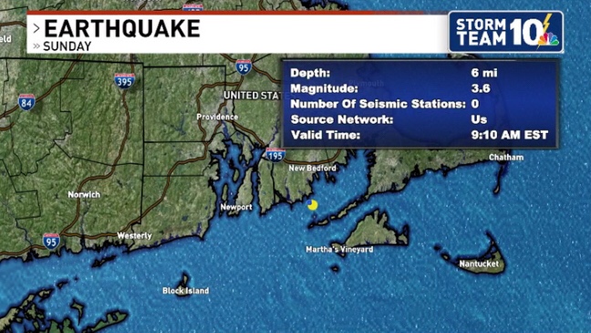
Did you feel it? At 9:10 am EST Sunday morning, a Magnitude 3.6 earthquake struck just south of Bliss Corner, Massachusetts, which is a census-designated place in Dartmouth. If you felt it, report it!

While minor earthquakes do happen from time to time in New England, tremors that are felt by a large number of people and that cause damage are rare.

Earthquake Report

The earthquake was originally measured as a magnitude 4.2 on the Richter scale by the United States Geological Surgey (USGS) before changing to a 3.6.

Earthquakes in New England and most places east of the Rocky Mountains are much different than the ones that occur along well-known fault lines in California and along the West Coast.

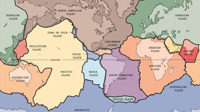
Rhode Island and Southeastern Massachusetts fall nearly in the center of the North American Plate, one of 15 (seven primary, eight secondary) that cover the Earth.

Earth’s tectonic plates

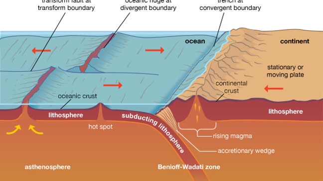
Tectonic plates move ever-so-slowly, and as they either push into each other, pull apart, or slide side-by-side, earthquakes are possible within the bedrock, usually miles deep.

Most of New England’s and Long Island’s bedrock was assembled as continents collided to form a supercontinent 500-300 million years ago, raising the northern Appalachian Mountains.

Plate tectonics (Courtesy: Encyclopaedia Britannica)

Fault lines left over from the creation of the Appalachian Mountains can still lead to earthquakes locally, and many faults remain undetected. According to the USGS, few, if any, earthquakes in New England can be linked to named faults.

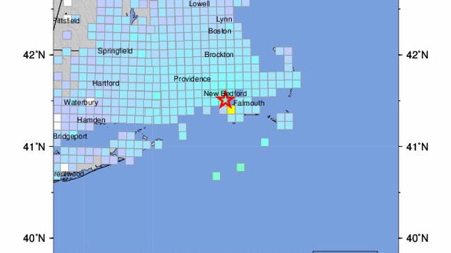
While earthquakes in New England are generally much weaker compared to those on defined fault lines, their reach is still impressive. Sunday’s 3.6 was felt in Rhode Island, Massachusetts, Connecticut, New York, and New Hampshire.

USGS Community Internet Intensity Map

While M 3.6 earthquakes rarely cause damage, some minor cracks were reported on social media from the shaking.

According to the USGS, moderately damaging earthquakes strike somewhere in the region every few decades, and smaller earthquakes are felt roughly twice a year.

The largest known New England earthquakes occurred in 1638 (magnitude 6.5) in Vermont or New Hampshire, and in 1755 (magnitude 5.8) offshore from Cape Ann northeast of Boston.

The most recent New England earthquake to cause moderate damage occurred in 1940 (magnitude 5.6) in central New Hampshire. 

Wednesday, November 2, 2022

Quakeland: On the Road to America’s Next Devastating Earthquake: Revelation 6


Quakeland: On the Road to America’s Next Devastating Earthquake
Roger BilhamQuakeland: New York and the Sixth Seal (Revelation 6:12)
Given recent seismic activity — political as well as geological — it’s perhaps unsurprising that two books on earthquakes have arrived this season. One is as elegant as the score of a Beethoven symphony; the other resembles a diary of conversations overheard during a rock concert. Both are interesting, and both relate recent history to a shaky future.
Journalist Kathryn Miles’s Quakeland is a litany of bad things that happen when you provoke Earth to release its invisible but ubiquitous store of seismic-strain energy, either by removing fluids (oil, water, gas) or by adding them in copious quantities (when extracting shale gas in hydraulic fracturing, also known as fracking, or when injecting contaminated water or building reservoirs). To complete the picture, she describes at length the bad things that happen during unprovoked natural earthquakes. As its subtitle hints, the book takes the form of a road trip to visit seismic disasters both past and potential, and seismologists and earthquake engineers who have first-hand knowledge of them. Their colourful personalities, opinions and prejudices tell a story of scientific discovery and engineering remedy.
Miles poses some important societal questions. Aside from human intervention potentially triggering a really damaging earthquake, what is it actually like to live in neighbourhoods jolted daily by magnitude 1–3 earthquakes, or the occasional magnitude 5? Are these bumps in the night acceptable? And how can industries that perturb the highly stressed rocks beneath our feet deny obvious cause and effect? In 2015, the Oklahoma Geological Survey conceded that a quadrupling of the rate of magnitude-3 or more earthquakes in recent years, coinciding with a rise in fracking, was unlikely to represent a natural process. Miles does not take sides, but it’s difficult for the reader not to.
She visits New York City, marvelling at subway tunnels and unreinforced masonry almost certainly scheduled for destruction by the next moderate earthquake in the vicinity. She considers the perils of nuclear-waste storage in Nevada and Texas, and ponders the risks to Idaho miners of rock bursts — spontaneous fracture of the working face when the restraints of many million years of confinement are mined away. She contemplates the ups and downs of the Yellowstone Caldera — North America’s very own mid-continent supervolcano — and its magnificently uncertain future. Miles also touches on geothermal power plants in southern California’s Salton Sea and elsewhere; the vast US network of crumbling bridges, dams and oil-storage farms; and the magnitude 7–9 earthquakes that could hit California and the Cascadia coastline of Oregon and Washington state this century. Amid all this doom, a new elementary school on the coast near Westport, Washington, vulnerable to inbound tsunamis, is offered as a note of optimism. With foresight and much persuasion from its head teacher, it was engineered to become an elevated safe haven.
Miles briefly discusses earthquake prediction and the perils of getting it wrong (embarrassment in New Madrid, Missouri, where a quake was predicted but never materialized; prison in L’Aquila, Italy, where scientists failed to foresee a devastating seismic event) and the successes of early-warning systems, with which electronic alerts can be issued ahead of damaging seismic waves. Yes, it’s a lot to digest, but most of the book obeys the laws of physics, and it is a engaging read. One just can’t help wishing that Miles’s road trips had taken her somewhere that wasn’t a disaster waiting to happen.
Catastrophic damage in Anchorage, Alaska, in 1964, caused by the second-largest earthquake in the global instrumental record.
In The Great Quake, journalist Henry Fountain provides us with a forthright and timely reminder of the startling historical consequences of North America’s largest known earthquake, which more than half a century ago devastated southern Alaska. With its epicentre in Prince William Sound, the 1964 quake reached magnitude 9.2, the second largest in the global instrumental record. It released more energy than either the 2004 Sumatra–Andaman earthquake or the 2011 Tohoku earthquake off Japan; and it generated almost as many pages of scientific commentary and description as aftershocks. Yet it has been forgotten by many.
The quake was scientifically important because it occurred at a time when plate tectonics was in transition from hypothesis to theory. Fountain expertly traces the theory’s historical development, and how the Alaska earthquake was pivotal in nailing down one of the most important predictions. The earthquake caused a fjordland region larger than England to subside, and a similarly huge region of islands offshore to rise by many metres; but its scientific implications were not obvious at the time. Eminent seismologists thought that a vertical fault had slipped, drowning forests and coastlines to its north and raising beaches and islands to its south. But this kind of fault should have reached the surface, and extended deep into Earth’s mantle. There was no geological evidence of a monster surface fault separating these two regions, nor any evidence for excessively deep aftershocks. The landslides and liquefied soils that collapsed houses, and the tsunami that severely damaged ports and infrastructure, offered no clues to the cause.
“Previous earthquakes provide clear guidance about present-day vulnerability.” The hero of The Great Quake is the geologist George Plafker, who painstakingly mapped the height reached by barnacles lifted out of the intertidal zone along shorelines raised by the earthquake, and documented the depths of drowned forests. He deduced that the region of subsidence was the surface manifestation of previously compressed rocks springing apart, driving parts of Alaska up and southwards over the Pacific Plate. His finding confirmed a prediction of plate tectonics, that the leading edge of the Pacific Plate plunged beneath the southern edge of Alaska along a gently dipping thrust fault. That observation, once fully appreciated, was applauded by the geophysics community.
Fountain tells this story through the testimony of survivors, engineers and scientists, interweaving it with the fascinating history of Alaska, from early discovery by Europeans to purchase from Russia by the United States in 1867, and its recent development. Were the quake to occur now, it is not difficult to envisage that with increased infrastructure and larger populations, the death toll and price tag would be two orders of magnitude larger than the 139 fatalities and US$300-million economic cost recorded in 1964.
What is clear from these two books is that seismicity on the North American continent is guaranteed to deliver surprises, along with unprecedented economic and human losses. Previous earthquakes provide clear guidance about the present-day vulnerability of US infrastructure and populations. Engineers and seismologists know how to mitigate the effects of future earthquakes (and, in mid-continent, would advise against the reckless injection of waste fluids known to trigger earthquakes). It is merely a matter of persuading city planners and politicians that if they are tempted to ignore the certainty of the continent’s seismic past, they should err on the side of caution when considering its seismic future.

A Closer Look At The Sixth Seal (Revelation 6:12)


A Look at the Tri-State’s Active Fault Line

Monday, March 14, 2011
The Ramapo Fault is the longest fault in the Northeast that occasionally makes local headlines when minor tremors cause rock the Tri-State region. It begins in Pennsylvania, crosses the Delaware River and continues through Hunterdon, Somerset, Morris, Passaic and Bergen counties before crossing the Hudson River near Indian Point nuclear facility.
In the past, it has generated occasional activity that generated a 2.6 magnitude quake in New Jersey’s Peakpack/Gladstone area and 3.0 magnitude quake in Mendham.
“There is occasional seismic activity in New Jersey,” said Robinson. “There have been a few quakes locally that have been felt and done a little bit of damage over the time since colonial settlement — some chimneys knocked down in Manhattan with a quake back in the 18th century, but nothing of a significant magnitude.”
Robinson said the Ramapo has on occasion registered a measurable quake but has not caused damage: “The Ramapo fault is associated with geological activities back 200 million years ago, but it’s still a little creaky now and again,” he said.
“More recently, in the 1970s and early 1980s, earthquake risk along the Ramapo Fault received attention because of its proximity to Indian Point,” according to the New Jersey Geological Survey website.
Historically, critics of the Indian Point Nuclear facility in Westchester County, New York, did cite its proximity to the Ramapo fault line as a significant risk.
“Subsequent investigations have shown the 1884 Earthquake epicenter was actually located in Brooklyn, New York, at least 25 miles from the Ramapo Fault,” according to the New Jersey Geological Survey website.