Showing posts with label crevelation 6. Show all posts

Wednesday, June 3, 2026

History Warns New York Is The Sixth Seal

 New York Earthquake 1884
Friday, 18 March 2011 – 9:23pm IST | Place: NEW YORK | Agency: ANI
If the past is any indication, New York can be hit by an earthquake, claims John Armbruster, a seismologist at Columbia University’s Lamont-Doherty Earth Observatory.
According to the New York Daily News, Lynn Skyes, lead author of a recent study by seismologists at the Lamont-Doherty Earth Observatory adds that a magnitude-6 quake hits the area about every 670 years, and magnitude-7 every 3,400 years.
A 5.2-magnitude quake shook New York City in 1737 and another of the same severity hit in 1884.
Tremors were felt from Maine to Virginia.
„The problem here comes from many subtle faults,“ explained Skyes after the study was published.
He adds: „We now see there is earthquake activity on them. Each one is small, but when you add them up, they are probably more dangerous than we thought.“
Armbruster says a 5.0-magnitude earthquake today likely would result in casualties and hundreds of millions of dollars in damage.
„I would expect some people to be killed,“ he notes.

Tuesday, May 12, 2020

Brace Yourselves for the Sixth Seal (Revelation 6)

http://www.ldeo.columbia.edu/news/images/nj-quake-030201.gif


A couple of hundred thousand years ago, an M 7.2 earthquake shook what is now New Hampshire. Just a few thousand years ago, an M 7.5 quake ruptured just off the coast of Massachusetts. And then there’s New York.
Since the first western settlers arrived there, the state has witnessed 200 quakes of magnitude 2.0 or greater, making it the third most seismically active state east of the Mississippi (Tennessee and South Carolina are ranked numbers one and two, respectively). About once a century, New York has also experienced an M 5.0 quake capable of doing real damage.
The most recent one near New York City occurred in August of 1884. Centered off Long Island’s Rockaway Beach, it was felt over 70,000 square miles. It also opened enormous crevices near the Brooklyn reservoir and knocked down chimneys and cracked walls in Pennsylvania and Connecticut. Police on the Brooklyn Bridge said it swayed “as if struck by a hurricane” and worried the bridge’s towers would collapse. Meanwhile, residents throughout New York and New Jersey reported sounds that varied from explosions to loud rumblings, sometimes to comic effect. At the funeral of Lewis Ingler, a small group of mourners were watching as the priest began to pray. The quake cracked an enormous mirror behind the casket and knocked off a display of flowers that had been resting on top of it. When it began to shake the casket’s silver handles, the mourners decided the unholy return of Lewis Ingler was more than they could take and began flinging themselves out windows and doors.
Not all stories were so light. Two people died during the quake, both allegedly of fright. Out at sea, the captain of the brig Alice felt a heavy lurch that threw him and his crew, followed by a shaking that lasted nearly a minute. He was certain he had hit a wreck and was taking on water.
A day after the quake, the editors of The New York Times sought to allay readers’ fear. The quake, they said, was an unexpected fluke never to be repeated and not worth anyone’s attention: “History and the researches of scientific men indicate that great seismic disturbances occur only within geographical limits that are now well defined,” they wrote in an editorial. “The northeastern portion of the United States . . . is not within those limits.” The editors then went on to scoff at the histrionics displayed by New York residents when confronted by the quake: “They do not stop to reason or to recall the fact that earthquakes here are harmless phenomena. They only know that the solid earth, to whose immovability they have always turned with confidence when everything else seemed transitory, uncertain, and deceptive, is trembling and in motion, and the tremor ceases long before their disturbed minds become tranquil.”
That’s the kind of thing that drives Columbia’s Heather Savage nuts.
Across town, Charles Merguerian has been studying these faults the old‐fashioned way: by getting down and dirty underground. He’s spent the past forty years sloshing through some of the city’s muckiest places: basements and foundations, sewers and tunnels, sometimes as deep as 750 feet belowground. His tools down there consist primarily of a pair of muck boots, a bright blue hard hat, and a pickax. In public presentations, he claims he is also ably abetted by an assistant hamster named Hammie, who maintains his own website, which includes, among other things, photos of the rodent taking down Godzilla.
That’s just one example why, if you were going to cast a sitcom starring two geophysicists, you’d want Savage and Merguerian to play the leading roles. Merguerian is as eccentric and flamboyant as Savage is earnest and understated. In his press materials, the former promises to arrive at lectures “fully clothed.” Photos of his “lab” depict a dingy porta‐john in an abandoned subway tunnel. He actively maintains an archive of vintage Chinese fireworks labels at least as extensive as his list of publications, and his professional website includes a discography of blues tunes particularly suitable for earthquakes. He calls female science writers “sweetheart” and somehow manages to do so in a way that kind of makes them like it (although they remain nevertheless somewhat embarrassed to admit it).
It’s Merguerian’s boots‐on‐the‐ground approach that has provided much of the information we need to understand just what’s going on underneath Gotham. By his count, Merguerian has walked the entire island of Manhattan: every street, every alley. He’s been in most of the tunnels there, too. His favorite one by far is the newest water tunnel in western Queens. Over the course of 150 days, Merguerian mapped all five miles of it. And that mapping has done much to inform what we know about seismicity in New York.
Most importantly, he says, it provided the first definitive proof of just how many faults really lie below the surface there. And as the city continues to excavate its subterranean limits, Merguerian is committed to following closely behind. It’s a messy business.
Down below the city, Merguerian encounters muck of every flavor and variety. He power‐washes what he can and relies upon a diver’s halogen flashlight and a digital camera with a very, very good flash to make up the difference. And through this process, Merguerian has found thousands of faults, some of which were big enough to alter the course of the Bronx River after the last ice age.
His is a tricky kind of detective work. The center of a fault is primarily pulverized rock. For these New York faults, that gouge was the very first thing to be swept away by passing glaciers. To do his work, then, he’s primarily looking for what geologists call “offsets”—places where the types of rock don’t line up with one another. That kind of irregularity shows signs of movement over time—clear evidence of a fault.
Merguerian has found a lot of them underneath New York City.
Each time that occurred, the land currently known as the Mid‐Atlantic underwent an accordion effect as it was violently folded into itself again and again. The process created immense mountains that have eroded over time and been further scoured by glaciers. What remains is a hodgepodge of geological conditions ranging from solid bedrock to glacial till to brittle rock still bearing the cracks of the collision. And, says Merguerian, any one of them could cause an earthquake.
You don’t have to follow him belowground to find these fractures. Even with all the development in our most built‐up metropolis, evidence of these faults can be found everywhere—from 42nd Street to Greenwich Village. But if you want the starkest example of all, hop the 1 train at Times Square and head uptown to Harlem. Not far from where the Columbia University bus collects people for the trip to the Lamont‐Doherty Earth Observatory, the subway tracks seem to pop out of the ground onto a trestle bridge before dropping back down to earth. That, however, is just an illusion. What actually happens there is that the ground drops out below the train at the site of one of New York’s largest faults. It’s known by geologists in the region as the Manhattanville or 125th Street Fault, and it runs all the way across the top of Central Park and, eventually, underneath Long Island City. Geologists have known about the fault since 1939, when the city undertook a massive subway mapping project, but it wasn’t until recently that they confirmed its potential for a significant quake.
In our lifetimes, a series of small earthquakes have been recorded on the Manhattanville Fault including, most recently, one on October 27, 2001. Its epicenter was located around 55th and 8th—directly beneath the original Original Soupman restaurant, owned by restaurateur Ali Yeganeh, the inspiration for Seinfeld’s Soup Nazi. That fact delighted sitcom fans across the country, though few Manhattanites were in any mood to appreciate it.
The October 2001 quake itself was small—about M 2.6—but the effect on residents there was significant. Just six weeks prior, the city had been rocked by the 9/11 terrorist attacks that brought down the World Trade Center towers. The team at Lamont‐Doherty has maintained a seismic network in the region since the ’70s. They registered the collapse of the first tower at M 2.1. Half an hour later, the second tower crumbled with even more force and registered M 2.3. In a city still shocked by that catastrophe, the early‐morning October quake—several times greater than the collapse of either tower—jolted millions of residents awake with both reminders of the tragedy and fear of yet another attack. 9‐1‐1 calls overwhelmed dispatchers and first responders with reports of shaking buildings and questions about safety in the city. For seismologists, though, that little quake was less about foreign threats to our soil and more about the possibility of larger tremors to come.
“Gee whiz!” He laughs when I pose this question. “That’s the holy grail of seismicity, isn’t it?”
He says all we can do to answer that question is “take the pulse of what’s gone on in recorded history.” To really have an answer, we’d need to have about ten times as much data as we do today. But from what he’s seen, the faults below New York are very much alive.
“These guys are loaded,” he tells me.
He says he is also concerned about new studies of a previously unknown fault zone known as the Ramapo that runs not far from the city. Savage shares his concerns. They both think it’s capable of an M 6.0 quake or even higher—maybe even a 7.0. If and when, though, is really anybody’s guess.
“We literally have no idea what’s happening in our backyard,” says Savage.
What we do know is that these quakes have the potential to do more damage than similar ones out West, mostly because they are occurring on far harder rock capable of propagating waves much farther. And because these quakes occur in places with higher population densities, these eastern events can affect a lot more people. Take the 2011 Virginia quake: Although it was only a moderate one, more Americans felt it than any other one in our nation’s history.
That’s the thing about the East Coast: Its earthquake hazard may be lower than that of the West Coast, but the total effect of any given quake is much higher. Disaster specialists talk about this in terms of risk, and they make sense of it with an equation that multiplies the potential hazard of an event by the cost of damage and the number of people harmed. When you take all of those factors into account, the earthquake risk in New York is much greater than, say, that in Alaska or Hawaii or even a lot of the area around the San Andreas Fault.
Merguerian has been sounding the alarm about earthquake risk in the city since the ’90s. He admits he hasn’t gotten much of a response. He says that when he first proposed the idea of seismic risk in New York City, his fellow scientists “booed and threw vegetables” at him. He volunteered his services to the city’s Office of Emergency Management but says his original offer also fell on deaf ears.
“So I backed away gently and went back to academia.”
Today, he says, the city isn’t much more responsive, but he’s getting a much better response from his peers.
He’s glad for that, he says, but it’s not enough. If anything, the events of 9/11, along with the devastation caused in 2012 by Superstorm Sandy, should tell us just how bad it could be there.
He and Savage agree that what makes the risk most troubling is just how little we know about it. When it comes right down to it, intraplate faults are the least understood. Some scientists think they might be caused by mantle flow deep below the earth’s crust. Others think they might be related to gravitational energy. Still others think quakes occurring there might be caused by the force of the Atlantic ridge as it pushes outward. Then again, it could be because the land is springing back after being compressed thousands of years ago by glaciers (a phenomenon geologists refer to as seismic rebound).
Adapted from Quakeland: On the Road to America’s Next Devastating Earthquake by Kathryn Miles, published by Dutton, an imprint of Penguin Publishing Group, a division of Penguin Random House, LLC. Copyright © 2017 by Kathryn Miles.

Final Siren Tests Before the Sixth Seal (Revelation 6:12)

May 7, 2020
BUCHANAN – Residents in the 10-mile radius around the Indian Point nuclear power plant are advised that a full-volume test of the Indian Point Energy Center siren system will be conducted between 10 a.m. and 11 a.m. on Wednesday, May 27.
During this full-system activation test, sirens will sound simultaneously for four minutes.  The sirens will sound at full-volume for the entire duration of the test.  No action on the part of the public is necessary or required for this drill.
The 10-mile radius encompasses a portion of Westchester, Putnam, Rockland and Orange counties.

Saturday, May 9, 2020

New York Quake Overdue (The Sixth Seal) (Revelation 6:12)


http://www.gothamgazette.com/graphics/2008/09/skyesfig3_cropped.gif


Won-Young Kim, who runs the seismographic network for the Northeast at Columbia University’s Lamont-Doherty Earth Observatory, said the city is well overdue for a big earthquake.
The last big quake to hit New York City was a 5.3-magnitude tremor in 1884 that happened at sea in between Brooklyn and Sandy Hook. While no one was killed, buildings were damaged.
Kim said the city is likely to experience a big earthquake every 100 years or so.
“It can happen anytime soon,” Kim said. “We can expect it any minute, we just don’t know when and where.”
New York has never experienced a magnitude 6 or 7 earthquake, which are the most dangerous. But magnitude 5 quakes could topple brick buildings and chimneys.
Seismologist John Armbruster said a magnitude 5 quake that happened now would be more devastating than the one that happened in 1884.

Tuesday, April 28, 2020

Hundreds Of Earthquakes Before the Sixth Seal (Revelation 6:12)


November 3, 2019 by Michael Snyder
Why is the mainstream media being so quiet about all of the seismic activity that has been happening all across the United States?  During the last 7 days, there has been an earthquake swarm directly along the New Madrid Fault zone, Kansas and Oklahoma have been hit by a very unusual number of significant quakes, and there have been several sizable seismic events in the vicinity of the Yellowstone supervolcano.  But of course the west coast is getting hammered more than anyone else.  According to Cal Tech, there have been more than 1000 earthquakes in California and Nevada over the last week, but of course most of them have been very small.  Overall, the latest USGS numbers tell us that there have been more than 2,000 earthquakes nationally during the last 7 days, and apparently we aren’t supposed to be alarmed by that.  But could it be possible that all of this seismic activity is leading up to something really big?
Over the weekend, we witnessed some very unusual quakes in the middle of the country.  On Sunday, a magnitude 3.2 earthquake rattled Kansas…
The Kansas quake hit at 9:08 p.m. Central time near South Hutchinson, northwest of Wichita, according to the USGS. About 175 people reported feeling the tremor, some as far away as Osborne and Concordia, Kansas.
Thankfully that quake hit in an area with a very low population density, and so it didn’t affect that many people.
But then on Sunday, a series of relatively large earthquakes hammered Oklahoma…
A 3.0-magnitude earthquake hit near Fairview in northern Oklahoma, at 1 a.m. Sunday, followed by a 2.6-magnitude quake at 1:37 a.m. near Quinton in eastern Oklahoma, the USGS reports. A 2.7-magnitude tremor rattled Waukomis in northern Oklahoma at 4:25 p.m. Saturday
Overall, there have been 143 earthquakes in Oklahoma in the last 30 days, and the increasing level of seismic activity in that part of the nation definitely has a lot of people on edge.
But of much greater concern is what has been happening along the west coast.  The two major quakes that hit California in July were followed by more than 100,000 aftershocks, and scientists are warning that this “may have increased stress on parts of a major dormant fault line”…
A series of earthquakes which shook Southern California earlier this year may have increased stress on parts of a major dormant fault line which has not produced any significant activity since records began, according to a study.
Scientists from the University of Iowa examined the so-called Ridgecrest earthquakes, which began with a 6.4 magnitude foreshock in the Mojave Desert on July 4, followed the next day by a 7.1 magnitude quake—the largest in Southern California for two decades. In addition, more than 100,000 smaller aftershocks were recorded.
The “dormant fault line” which they are talking about is the Garlock Fault.
And the Garlock Fault runs directly into the San Andreas Fault.
One day there will be a massive quake that fundamentally alters the geography of southern California, and let us hope that day is delayed for as long as possible.
Meanwhile, we have also witnessed some unusual rumbling off the coast farther north.
In fact, five large earthquakes were detected off of the Oregon coast last month.  The following comes from a news story that was posted on October 21st…
A magnitude-4.6 earthquake Monday morning became the fifth to strike off the Oregon coast since the beginning of the month.
The quake rumbled around 6:47 a.m. about 120 miles west of Bandon and at a depth of roughly 6 miles, according to the U.S. Geological Survey.
On Thursday, a magnitude-4.7 temblor struck about 95 miles from Port Orford — just hours after students in Coos and Curry counties participated in an annual earthquake drill.
The reason why these quakes are so alarming is because they happened in the vicinity of the Cascadia Subduction Zone.
As Steve Quayle recently told Greg Hunter, someday the Cascadia Subduction Zone will suddenly come to life, and it will be the greatest natural disaster that we have seen so far in all of American history…
What’s the worst case scenario if the Cascadia Subduction Zone lets loose and volcanos, earthquakes and tsunamis are unleashed? Quayle says “The amount of damage, and I am going to choose my words carefully, is going to be precedent setting. It’s going to be the combination of volcanos going off that are inland from the subduction zone where the plates meet, coupled with tsunamis. . . . When this happens, you will lose eight million to twenty million people. When it happens, you will lose all productivity in the electronic field, obviously Silicon Valley, and all food production in all of California, Oregon and Washington. When it happens, you will have a State of Emergency unlike any other. How about the refugees? There will be 3.5 million refugees to take care of. When this happens, what happens to the underground aquifers, and where does everybody go for fresh water? There will be years of drought, years of famine and years of water, water where did it all go? It is a very dire situation painted by computer models. This is not a sensational thing. It is a reality based, scientific study with the application of what happens.”
Quayle warns that the public would likely have roughly “15 minutes to get to safety,” and “the tsunami waves would be 500 to 1,500 feet tall.”
You can see the trailer for the new film that is being produced about the Cascadia Subduction Zone right here.  I am so glad that this movie is being made, because I have been trying to warn people about what is going to happen for a long time.  For example, the following comes from one of my previous articles entitled “You Have Been Warned: Experts Tell Us That A Cascadia Subduction Zone Earthquake And Tsunami Will Destroy Everything West Of Interstate 5”…
One day it will happen. With little or no warning, the Cascadia Subduction Zone will produce a catastrophic earthquake and accompanying tsunami that will essentially destroy everything west of Interstate 5 in the Pacific Northwest. It will be the worst natural disaster up to that point in American history, and as you will see below, the experts are saying that we are completely and utterly unprepared for it. Of course the San Andreas Fault gets more publicity, but the truth is that the Cascadia Subduction Zone is capable of producing a quake “almost 30 times more energetic” than anything the San Andreas Fault can produce.
Scientists assure us that it is just a matter of time before such a disaster takes place.
So essentially those living right along the coast are taking a huge gamble.
Day after day, they hope that there is still at least a little bit more time before the Cascadia Subduction Zone absolutely devastates the Northwest.
Of course up until now that gamble has paid off, but one day their luck will suddenly run out.
About the Author: I am a voice crying out for change in a society that generally seems content to stay asleep.  My name is Michael Snyder and I am the publisher of The Economic Collapse Blog, End Of The American Dream and The Most Important News, and the articles that I publish on those sites are republished on dozens of other prominent websites all over the globe.  I have written four books that are available on Amazon.com including The Beginning Of The End, Get Prepared Now, and Living A Life That Really Matters.  (#CommissionsEarned)  By purchasing those books you help to support my work.  I always freely and happily allow others to republish my articles on their own websites, but due to government regulations I can only allow this to happen if this “About the Author” section is included with each article.  In order to comply with those government regulations, I need to tell you that the controversial opinions in this article are mine alone and do not necessarily reflect the views of the websites where my work is republished.  This article may contain opinions on political matters, but it is not intended to promote the candidacy of any particular political candidate.  The material contained in this article is for general information purposes only, and readers should consult licensed professionals before making any legal, business, financial or health decisions.  Those responding to this article by making comments are solely responsible for their viewpoints, and those viewpoints do not necessarily represent the viewpoints of Michael Snyder or the operators of the websites where my work is republished.  I encourage you to follow me on social media on Facebook and Twitter, and any way that you can share these articles with others is a great help.

New York Begins to Move BECAUSE OF Indian Point (Revelation 6:12)

April 27, 2020 Kit Kennedy
This blog is dedicated to the memory of former New York State Assembly Member Richard Brodsky (May 4, 1946 – April 8, 2020). Richard was an environmental champion par excellence and a tireless advocate for the closure of Indian Point. He will be deeply missed.
On April 30, 2020, New York State will mark a major milestone in the fight for public health and the environment when one of two nuclear reactors at the troubled and aging Indian Point nuclear power plant, located 24 miles north of New York City, is permanently shuttered. In January 2017, under a negotiated agreement between New York State, Entergy (the facility’s owner) and the environmental organization Riverkeeper, Governor Cuomo announced that the first Indian Point reactor would close in April 2020 and the second Indian Point reactor would close in April 2021.
The first nuclear reactor at the Indian Point nuclear power station will shut down on April 30th of this year; the second will close down in April 2021
Tony Fischer via Flickr
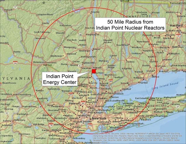
The planned, orderly closure of Indian Point is welcome news for the nearly 20 million people living within 50 miles of Indian Point. NRDC has long opposed relicensing its two reactors because of Indian Point’s history of operational, safety, and environmental problems, as well as the grave risk of a nuclear accident so close to the nation’s largest city. Fortunately, the Cuomo administration’s groundbreaking clean energy policies have helped to ease the transition to safer, carbon free alternatives—namely energy efficiency, land-based and offshore wind power, and solar power. As we have done for many years, NRDC will work to ensure that Indian Point’s power is expeditiously replaced with the best mix of clean energy possible.
Indian Point’s Public Health Risks
Indian Point, located in the most densely populated part of our country, presents a unique set of risks. For decades, we’ve heard about one alarming incident after another, including a May 2015 transformer fire which sent thousands of gallons of oil into the Hudson River, radioactive releases into groundwater, failed accident drills, and inadequate disaster planning. The power plant’s two operating units lie within a mile of a significant seismic zone discovered after the plant was built in the 1960s, prompting the Nuclear Regulatory Commission (NRC) to deem Indian Point one of the top ten facilities considered most in need of reevaluation for earthquake vulnerability; one of the 9/11 terrorists had cited the plant as a potential target. Indian Point’s proximity to New York City and the rest of the densely populated tri-state area made potential impacts of an accident severe. My colleague Dr. Matthew McKinzie, a nuclear physicist and director of NRDC’s nuclear team, has blogged about these risks here.
Indian Point Energy Center Location Map
Indian Point’s Closure Won’t Impact Reliability
The New York Independent System Operator (NYISO)—which is charged with ensuring the reliability of New York’s electric grid and running our wholesale electricity markets—noted last year that annual electricity demand in New York State has declined over the last decade after a record high in 2007 and recently predicted that electricity usage will remain essentially flat over the next decade. That’s due in large part to federal, state, and City energy efficiency efforts, including stronger building energy codes and appliance and equipment standards, as well as the aggressive energy efficiency goals that were memorialized in the Climate Leadership and Community Protection Act (CLCPA), New York’s groundbreaking climate legislation enacted last year.
In addition to robust energy efficiency efforts, the state’s rapid deployment of clean, distributed “behind-the-meter” resources like rooftop solar, battery storage and demand response has contributed to a decline in the state’s reliance on bulk system power supply. NYISO further expects that peak electricity demand (the amount of power that we use on the hottest days) will decline slightly over the coming decade, thanks again largely to the state’s clean energy initiatives. And as noted below, the state Public Service Commission has been planning for the facility’s retirement and replacement power needs for some time, even before the closure agreement in 2017. All of this means that it is easier to retire Indian Point today than it might have been a decade ago. Indeed, NYISO’s own analysis concluded Indian Point can retire on schedule without having any impact on the grid’s ability to keep the lights on.
New York Will Meet Its Aggressive Climate Goals Without Indian Point
In announcing Indian Point’s closure in 2017, Governor Cuomo committed that New York’s “leadership on energy and climate change will ensure that Indian Point’s closure will not have an adverse impact on carbon emissions at the regional level. Through the Regional Greenhouse Gas Initiative, the state will continue to drive reductions in greenhouse gases across the power sector.” As outlined below, New York State is poised to meet this commitment.
1 RGGI Ensures Regional Emissions Progress: Consistent with Governor Cuomo’s commitment, the Regional Greenhouse Gas Initiative (RGGI)—a multistate effort in the Northeast and Mid-Atlantic to cut power sector carbon pollution—agreed in 2017 to extend the program for another ten years and to strengthen its carbon cap. The RGGI states have committed to cut power plant carbon pollution 65% by 2030 and have already made significant progress toward that goal—emissions have been cut by more than half since the program started in 2009. Significantly, in the modeling that went into charting this carbon trajectory for the program, New York built in an assumption that both Indian Point units would retire in 2019—meaning the projected impacts of this development on regional carbon pollution and allowance prices are essentially already baked in.
2 Dirty Peaker Plants Phasing Out: New York State has also taken further steps to reduce other forms of health-harming air pollution from fossil fuel power plants, including the recent adoption of a critical new requirement that imposes a much stricter limit on nitrogen oxide pollution during the summertime, when electricity demand can spike and when air pollution is most deadly. This regulation will importantly begin to shutter the old, dirty peaker plants throughout the state  (many of which are located in environmental justice communities) and open up opportunities to replace those facilities with battery storage.
3 CLCPA is a Game Changer: New York State has acted aggressively over the last three years to accelerate clean energy progress and is now required to do so by law. The CLCPA mandates that New York State achieve net zero carbon emissions by 2040 and also includes groundbreaking equity provisions to ensure that climate and clean energy benefits are realized by environmental justice communities. This major progress on climate action in New York State was spurred by years of advocacy and activism by the NYRenews coalition and the New York environmental justice community. The CLCPA also includes nation-leading climate and clean energy mandates for solar power, offshore wind, battery storage and energy efficiency. More about the CLCPA is available here.
And so much has been achieved already by New York State in the last decade:
There are already nearly 1,300 megawatts of demand response (DR) resources (programs that compensate customers for agreeing to cut their electricity use when called upon during high use periods) in place to cut electric power on peak summer days, and there are additional megawatts of retail DR programs approved by the Commission that are operated by utilities like Con Edison.
New York’s groundbreaking NY-Sun solar power program was launched in 2013 and will continue to scale up solar projects on homes and businesses across the state. NY-Sun has been largely responsible for the incredible  growth in solar power throughout New York—nearly 1,800 percent since 2011. The CLCPA ensures that this progress will continue with the mandate to install 6 gigawatts of solar power by 2025.
New York is also taking bold action to install offshore wind in the waters off New York State. The CLCPA commits the state to building 9 gigawatts of offshore wind power by 2035, a nation-leading mandate. Last year, New York awarded contracts totaling 1.7 GW to several offshore wind projects after a competitive procurement process. And just last week, New York State approved its second offshore wind competitive procurement process for up to 2.5 GW, which will take place later this year.
Additional transmission capacity is also essential to facilitating the replacement of Indian Point’s power with clean energy. The New York Power Authority has been working to improve reliability and expand capacity on its transmission lines. The fully permitted and approved 1,000 MW TDI Champlain Hudson Power Express transmission project, which would bring low-carbon hydropower from Quebec to New York City, could also play a significant role in replacing Indian Point’s power if it is built.
New York City is also playing a pivotal role in ramping up energy efficiency and clean energy options. It has already adopted a number of policies to scale up solar through the NYC Solar Partnership, New York City Council legislation, and other initiatives—including easing regulatory obstacles, assistance with collective solar purchasing and shared solar installations, with a goal of 1,000 MW of solar power by 2030. Since 2015, solar PV deployment in New York City has quadrupled, with over 215 MW currently installed. This number is expected to increase significantly given the recently enacted Climate Mobilization Act (CMA), which requires that solar PV systems or green roofs be installed on certain new construction and renovation projects in New York City. Regarding energy efficiency, the City’s leadership role will continue to be critical—with policies building off of its Greener, Greater Buildings Plan expected to continue to reduce energy demand. Local Law 97, a critical piece of the CMA, is one of the most aggressive, wide-reaching laws in the country, as it will significantly reduce carbon emissions from the City’s mid- and large-sized buildings.
Next Steps
Make no mistake, we need to continue to work aggressively to ensure that New York State remains on track to meet its aggressive climate goals, phase out fossil fuels and protect public health and air quality in our communities, with special focus on environmental justice communities. Indeed, we must redouble these efforts.
We also need to ensure that the community around Indian Point and the workers at the plant are supported in the transition to a future without Indian Point. New York State and Entergy have made commitments to the community and plant workers which must be met. In 2015, New York State created a Cessation Mitigation Fund for community mitigation related to power plant close downs. This will be one source of community support once both Indian Point reactors are closed in April 2021.
Finally, we have to meet the challenge of cleaning up the Indian Point site and dealing with the nuclear waste that is currently housed there. Many years will need to be spent decommissioning Indian Point after decades of operation, and New York State and the environmental community need to work hard to ensure a thorough cleanup. And we still have the challenge of the nuclear waste that will remain on site until there is a national solution, but NRDC has charted a course forward to address that issue, with reliance on bedrock environmental laws.
Conclusion
There’s no question that Indian Point was sited in the wrong place some 50 years ago—a location where a severe accident would jeopardize the health of millions of people and where no large-scale evacuation plan would be remotely feasible. Governor Cuomo’s leadership over the past decade helped make Indian Point’s closure a reality. He deserves tremendous credit for his vision and tenacious pursuit of a goal that many dismissed as unachievable. For a decade, the New York Attorney General’s office and the State Department of Environmental Conservation led the charge in opposing the relicensing of Indian Point in the Nuclear Regulatory Commission proceeding and in other related litigation, helping to clear the way to the Indian Point closure agreement. And much credit and thanks go to our colleagues at Riverkeeper and Scenic Hudson, who have been NRDC’s valued allies and determined partners on Indian Point, Hudson River, and clean energy issues for decades. Clearwater and many other local and national groups have also played key roles on these issues over the years. It’s been an honor for NRDC to work with these and many other tireless advocates over the years. Check out the Beyond Indian Point website created by many of these and other activists.
This watershed moment demonstrates just how much can be achieved when we continue to fight for change. Just a decade ago, closing Indian Point seemed a daunting challenge. This week, the closure of the first Indian Point reactor will happen with no red flags from reliability monitors at NYISO, and against the backdrop of accelerated climate and clean energy progress in New York State that was almost unimaginable when we all launched this fight. The closure of the Indian Point Unit 2 this week shows what we can achieve when we dare to take on the biggest energy challenges and apply vision, passion, and skilled advocacy to the task.

Sunday, April 19, 2020

New York Quake Overdue (The Sixth Seal) (Revelation 6:12)

http://www.gothamgazette.com/graphics/2008/09/skyesfig3_cropped.gif


Won-Young Kim, who runs the seismographic network for the Northeast at Columbia University’s Lamont-Doherty Earth Observatory, said the city is well overdue for a big earthquake.
The last big quake to hit New York City was a 5.3-magnitude tremor in 1884 that happened at sea in between Brooklyn and Sandy Hook. While no one was killed, buildings were damaged.
Kim said the city is likely to experience a big earthquake every 100 years or so.
“It can happen anytime soon,” Kim said. “We can expect it any minute, we just don’t know when and where.”
New York has never experienced a magnitude 6 or 7 earthquake, which are the most dangerous. But magnitude 5 quakes could topple brick buildings and chimneys.
Seismologist John Armbruster said a magnitude 5 quake that happened now would be more devastating than the one that happened in 1884.

Government Experts Claim Indian Nuclear Plant is Safe (Revelation 6:12)

April 16, 2020
BUCHANAN – An expert team of Nuclear Regulatory Commission staff and outside specialists has concluded the Indian Point nuclear power plant would remain safe should there be a potential accident on a 42-inch natural gas pipeline near the plant. 
The team’s report also recommends several follow-up actions, including that the plant owner, Entergy, revisits the assumptions it made in its analysis.
The team’s safety conclusion is based on two factors. First, the Algonquin Incremental Market pipeline has a very small chance of rupture near Indian Point, due to the pipeline’s modern construction, quality control and additional “high consequence” requirements for inspection and an integrity management program.
Second, Indian Point’s safety systems sit well outside the potential impact zones for postulated AIM pipeline accident effects such as heat, pressure, and projectiles.
The team’s report was submitted in response to direction from Margaret Doane, the NRC’s executive director for Operations, following an NRC Inspector General report on the agency’s handling of public concerns about the pipeline issues.

Tuesday, April 7, 2020

The Ramapo: The Sixth Seal Fault Line (Revelation 6:12)

Image result for ramapo fault lineThe Ramapo fault and other New York City area faults 


 Map depicting the extent of the Ramapo Fault System in New York, New Jersey, and Pennsylvania
The Ramapo Fault, which marks the western boundary of the Newark rift basin, has been argued to be a major seismically active feature of this region, but it is difficult to discern the extent to which the Ramapo fault (or any other specific mapped fault in the area) might be any more of a source of future earthquakes than any other parts of the region. The Ramapo Fault zone spans more than 185 miles (300 kilometers) in New York, New Jersey, and Pennsylvania. It is a system of faults between the northern Appalachian Mountains and Piedmont areas to the east. This fault is perhaps the best known fault zone in the Mid-Atlantic region, and some small earthquakes have been known to occur in its vicinity. Recently, public knowledge about the fault has increased – especially after the 1970s, when the fault’s proximity to the Indian Point nuclear plant in New York was noticed.
There is insufficient evidence to unequivocally demonstrate any strong correlation of earthquakes in the New York City area with specific faults or other geologic structures in this region. The damaging earthquake affecting New York City in 1884 was probably not associated with the Ramapo fault because the strongest shaking from that earthquake occurred on Long Island (quite far from the trace of the Ramapo fault). The relationship between faults and earthquakes in the New York City area is currently understood to be more complex than any simple association of a specific earthquake with a specific mapped fault.
A 2008 study argued that a magnitude 6 or 7 earthquake might originate from the Ramapo fault zone, which would almost definitely spawn hundreds or even thousands of fatalities and billions of dollars in damage.Studying around 400 earthquakes over the past 300 years, the study also argued that there was an additional fault zone extending from the Ramapo Fault zone into southwestern Connecticut. As can be seen in the above figure of seismicity, earthquakes are scattered throughout this region, with no particular concentration of activity along the Ramapo fault, or along the hypothesized fault zone extending into southwestern Connecticut.
Just off the northern terminus of the Ramapo fault is the Indian Point Nuclear Power Plant, built between 1956 and 1960 by Consolidated Edison Company. The plant began operating in 1963, and it has been the subject of a controversy over concerns that an earthquake from the Ramapo fault will affect the power plant. Whether or not the Ramapo fault actually does pose a threat to this nuclear power plant remains an open question.

Two Centuries Before The Sixth Seal (Revelation 6:12)


Image result for 1755 massachusetts earthquake


It happened before, and it could happen again.
By Hilary Sargent @lilsarg
Boston.com Staff | 11.19.15 | 5:53 AM
The earthquake occurred in the waters off Cape Ann, and was felt within seconds in Boston, and as far away as Nova Scotia, the Chesapeake Bay, and upstate New York, according to the U.S. Geological Survey.
Seismologists have since estimated the quake to have been between 6.0 and 6.3 on the Richter scale, according to the Massachusetts Historical Society.
While there were no fatalities, the damage was extensive.
According to the USGS, approximately 100 chimneys and roofs collapsed, and over a thousand were damaged.
The worst damage occurred north of Boston, but the city was not unscathed.
A 1755 report in The Philadelphia Gazette described the quake’s impact on Boston:
“There was at first a rumbling noise like low thunder, which was immediately followed with such a violent shaking of the earth and buildings, as threw every into the greatest amazement, expecting every moment to be buried in the ruins of their houses. In a word, the instances of damage done to our houses and chimnies are so many, that it would be endless to recount them.”
The quake sent the grasshopper weathervane atop Faneuil Hall tumbling to the ground, according to the Massachusetts Historical Society.
An account of the earthquake, published in The Pennsylvania Gazette on December 4, 1755.
The earthquake struck at 4:30 in the morning, and the shaking lasted “near four minutes,” according to an entry John Adams, then 20, wrote in his diary that day.
The brief diary entry described the damage he witnessed.
“I was then at my Fathers in Braintree, and awoke out of my sleep in the midst of it,” he wrote. “The house seemed to rock and reel and crack as if it would fall in ruins about us. 7 Chimnies were shatter’d by it within one mile of my Fathers house.”
The shaking was so intense that the crew of one ship off the Boston coast became convinced the vessel had run aground, and did not learn about the earthquake until they reached land, according to the Massachusetts Historical Society.
In 1832, a writer for the Hampshire (Northampton) Gazette wrote about one woman’s memories from the quake upon her death.
“It was between 4 and 5 in the morning, and the moon shone brightly. She and the rest of the family were suddenly awaked from sleep by a noise like that of the trampling of many horses; the house trembled and the pewter rattled on the shelves. They all sprang out of bed, and the affrightted children clung to their parents. “I cannot help you dear children,” said the good mother, “we must look to God for help.
The Cape Ann earthquake came just 17 days after an earthquake estimated to have been 8.5-9.0 on the Richter scale struck in Lisbon, Portugal, killing at least 60,000 and causing untold damage.
There was no shortage of people sure they knew the impretus for the Cape Ann earthquake.
According to many ministers in and around Boston, “God’s wrath had brought this earthquake upon Boston,” according to the Massachusetts Historical Society.
In “Verses Occasioned by the Earthquakes in the Month of November, 1755,” Jeremiah Newland, a Taunton resident who was active in religious activities in the Colony, wrote that the earthquake was a reminder of the importance of obedience to God.
“It is becaufe we broke thy Laws,
that thou didst shake the Earth.
O what a Day the Scriptures say,
the EARTHQUAKE doth foretell;
O turn to God; lest by his Rod,
he cast thee down to Hell.”
Boston Pastor Jonathan Mayhew warned in a sermon that the 1755 earthquakes in Massachusetts and Portugal were “judgments of heaven, at least as intimations of God’s righteous displeasure, and warnings from him.”
There were some, though, who attempted to put forth a scientific explanation for the earthquake.
Well, sort of.
In a lecture delivered just a week after the earthquake, Harvard mathematics professor John Winthrop said the quake was the result of a reaction between “vapors” and “the heat within the bowels of the earth.” But even Winthrop made sure to state that his scientific theory “does not in the least detract from the majesty … of God.”
It has been 260 years since the Cape Ann earthquake. Some experts, including Boston College seismologist John Ebel, think New England could be due for another significant quake.
In a recent Boston Globe report, Ebel said the New England region “can expect a 4 to 5 magnitude quake every decade, a 5 to 6 every century, and a magnitude 6 or above every thousand years.”
If the Cape Ann earthquake occurred today, “the City of Boston could sustain billions of dollars of earthquake damage, with many thousands injured or killed,” according to a 1997 study by the US Army Corps of Engineers.

Tuesday, March 31, 2020

The Ramapo: The Sixth Seal Fault Line (Revelation 6:12)

Image result for ramapo fault lineThe Ramapo fault and other New York City area faults 


 Map depicting the extent of the Ramapo Fault System in New York, New Jersey, and Pennsylvania
The Ramapo Fault, which marks the western boundary of the Newark rift basin, has been argued to be a major seismically active feature of this region, but it is difficult to discern the extent to which the Ramapo fault (or any other specific mapped fault in the area) might be any more of a source of future earthquakes than any other parts of the region. The Ramapo Fault zone spans more than 185 miles (300 kilometers) in New York, New Jersey, and Pennsylvania. It is a system of faults between the northern Appalachian Mountains and Piedmont areas to the east. This fault is perhaps the best known fault zone in the Mid-Atlantic region, and some small earthquakes have been known to occur in its vicinity. Recently, public knowledge about the fault has increased – especially after the 1970s, when the fault’s proximity to the Indian Point nuclear plant in New York was noticed.
There is insufficient evidence to unequivocally demonstrate any strong correlation of earthquakes in the New York City area with specific faults or other geologic structures in this region. The damaging earthquake affecting New York City in 1884 was probably not associated with the Ramapo fault because the strongest shaking from that earthquake occurred on Long Island (quite far from the trace of the Ramapo fault). The relationship between faults and earthquakes in the New York City area is currently understood to be more complex than any simple association of a specific earthquake with a specific mapped fault.
A 2008 study argued that a magnitude 6 or 7 earthquake might originate from the Ramapo fault zone, which would almost definitely spawn hundreds or even thousands of fatalities and billions of dollars in damage.Studying around 400 earthquakes over the past 300 years, the study also argued that there was an additional fault zone extending from the Ramapo Fault zone into southwestern Connecticut. As can be seen in the above figure of seismicity, earthquakes are scattered throughout this region, with no particular concentration of activity along the Ramapo fault, or along the hypothesized fault zone extending into southwestern Connecticut.
Just off the northern terminus of the Ramapo fault is the Indian Point Nuclear Power Plant, built between 1956 and 1960 by Consolidated Edison Company. The plant began operating in 1963, and it has been the subject of a controversy over concerns that an earthquake from the Ramapo fault will affect the power plant. Whether or not the Ramapo fault actually does pose a threat to this nuclear power plant remains an open question.

Monday, December 16, 2019

Brace Yourselves for the Sixth Seal (Revelation 6)

http://www.ldeo.columbia.edu/news/images/nj-quake-030201.gif


A couple of hundred thousand years ago, an M 7.2 earthquake shook what is now New Hampshire. Just a few thousand years ago, an M 7.5 quake ruptured just off the coast of Massachusetts. And then there’s New York.
Since the first western settlers arrived there, the state has witnessed 200 quakes of magnitude 2.0 or greater, making it the third most seismically active state east of the Mississippi (Tennessee and South Carolina are ranked numbers one and two, respectively). About once a century, New York has also experienced an M 5.0 quake capable of doing real damage.
The most recent one near New York City occurred in August of 1884. Centered off Long Island’s Rockaway Beach, it was felt over 70,000 square miles. It also opened enormous crevices near the Brooklyn reservoir and knocked down chimneys and cracked walls in Pennsylvania and Connecticut. Police on the Brooklyn Bridge said it swayed “as if struck by a hurricane” and worried the bridge’s towers would collapse. Meanwhile, residents throughout New York and New Jersey reported sounds that varied from explosions to loud rumblings, sometimes to comic effect. At the funeral of Lewis Ingler, a small group of mourners were watching as the priest began to pray. The quake cracked an enormous mirror behind the casket and knocked off a display of flowers that had been resting on top of it. When it began to shake the casket’s silver handles, the mourners decided the unholy return of Lewis Ingler was more than they could take and began flinging themselves out windows and doors.
Not all stories were so light. Two people died during the quake, both allegedly of fright. Out at sea, the captain of the brig Alice felt a heavy lurch that threw him and his crew, followed by a shaking that lasted nearly a minute. He was certain he had hit a wreck and was taking on water.
A day after the quake, the editors of The New York Times sought to allay readers’ fear. The quake, they said, was an unexpected fluke never to be repeated and not worth anyone’s attention: “History and the researches of scientific men indicate that great seismic disturbances occur only within geographical limits that are now well defined,” they wrote in an editorial. “The northeastern portion of the United States . . . is not within those limits.” The editors then went on to scoff at the histrionics displayed by New York residents when confronted by the quake: “They do not stop to reason or to recall the fact that earthquakes here are harmless phenomena. They only know that the solid earth, to whose immovability they have always turned with confidence when everything else seemed transitory, uncertain, and deceptive, is trembling and in motion, and the tremor ceases long before their disturbed minds become tranquil.”
That’s the kind of thing that drives Columbia’s Heather Savage nuts.
Across town, Charles Merguerian has been studying these faults the old‐fashioned way: by getting down and dirty underground. He’s spent the past forty years sloshing through some of the city’s muckiest places: basements and foundations, sewers and tunnels, sometimes as deep as 750 feet belowground. His tools down there consist primarily of a pair of muck boots, a bright blue hard hat, and a pickax. In public presentations, he claims he is also ably abetted by an assistant hamster named Hammie, who maintains his own website, which includes, among other things, photos of the rodent taking down Godzilla.
That’s just one example why, if you were going to cast a sitcom starring two geophysicists, you’d want Savage and Merguerian to play the leading roles. Merguerian is as eccentric and flamboyant as Savage is earnest and understated. In his press materials, the former promises to arrive at lectures “fully clothed.” Photos of his “lab” depict a dingy porta‐john in an abandoned subway tunnel. He actively maintains an archive of vintage Chinese fireworks labels at least as extensive as his list of publications, and his professional website includes a discography of blues tunes particularly suitable for earthquakes. He calls female science writers “sweetheart” and somehow manages to do so in a way that kind of makes them like it (although they remain nevertheless somewhat embarrassed to admit it).
It’s Merguerian’s boots‐on‐the‐ground approach that has provided much of the information we need to understand just what’s going on underneath Gotham. By his count, Merguerian has walked the entire island of Manhattan: every street, every alley. He’s been in most of the tunnels there, too. His favorite one by far is the newest water tunnel in western Queens. Over the course of 150 days, Merguerian mapped all five miles of it. And that mapping has done much to inform what we know about seismicity in New York.
Most importantly, he says, it provided the first definitive proof of just how many faults really lie below the surface there. And as the city continues to excavate its subterranean limits, Merguerian is committed to following closely behind. It’s a messy business.
Down below the city, Merguerian encounters muck of every flavor and variety. He power‐washes what he can and relies upon a diver’s halogen flashlight and a digital camera with a very, very good flash to make up the difference. And through this process, Merguerian has found thousands of faults, some of which were big enough to alter the course of the Bronx River after the last ice age.
His is a tricky kind of detective work. The center of a fault is primarily pulverized rock. For these New York faults, that gouge was the very first thing to be swept away by passing glaciers. To do his work, then, he’s primarily looking for what geologists call “offsets”—places where the types of rock don’t line up with one another. That kind of irregularity shows signs of movement over time—clear evidence of a fault.
Merguerian has found a lot of them underneath New York City.
Each time that occurred, the land currently known as the Mid‐Atlantic underwent an accordion effect as it was violently folded into itself again and again. The process created immense mountains that have eroded over time and been further scoured by glaciers. What remains is a hodgepodge of geological conditions ranging from solid bedrock to glacial till to brittle rock still bearing the cracks of the collision. And, says Merguerian, any one of them could cause an earthquake.
You don’t have to follow him belowground to find these fractures. Even with all the development in our most built‐up metropolis, evidence of these faults can be found everywhere—from 42nd Street to Greenwich Village. But if you want the starkest example of all, hop the 1 train at Times Square and head uptown to Harlem. Not far from where the Columbia University bus collects people for the trip to the Lamont‐Doherty Earth Observatory, the subway tracks seem to pop out of the ground onto a trestle bridge before dropping back down to earth. That, however, is just an illusion. What actually happens there is that the ground drops out below the train at the site of one of New York’s largest faults. It’s known by geologists in the region as the Manhattanville or 125th Street Fault, and it runs all the way across the top of Central Park and, eventually, underneath Long Island City. Geologists have known about the fault since 1939, when the city undertook a massive subway mapping project, but it wasn’t until recently that they confirmed its potential for a significant quake.
In our lifetimes, a series of small earthquakes have been recorded on the Manhattanville Fault including, most recently, one on October 27, 2001. Its epicenter was located around 55th and 8th—directly beneath the original Original Soupman restaurant, owned by restaurateur Ali Yeganeh, the inspiration for Seinfeld’s Soup Nazi. That fact delighted sitcom fans across the country, though few Manhattanites were in any mood to appreciate it.
The October 2001 quake itself was small—about M 2.6—but the effect on residents there was significant. Just six weeks prior, the city had been rocked by the 9/11 terrorist attacks that brought down the World Trade Center towers. The team at Lamont‐Doherty has maintained a seismic network in the region since the ’70s. They registered the collapse of the first tower at M 2.1. Half an hour later, the second tower crumbled with even more force and registered M 2.3. In a city still shocked by that catastrophe, the early‐morning October quake—several times greater than the collapse of either tower—jolted millions of residents awake with both reminders of the tragedy and fear of yet another attack. 9‐1‐1 calls overwhelmed dispatchers and first responders with reports of shaking buildings and questions about safety in the city. For seismologists, though, that little quake was less about foreign threats to our soil and more about the possibility of larger tremors to come.
“Gee whiz!” He laughs when I pose this question. “That’s the holy grail of seismicity, isn’t it?”
He says all we can do to answer that question is “take the pulse of what’s gone on in recorded history.” To really have an answer, we’d need to have about ten times as much data as we do today. But from what he’s seen, the faults below New York are very much alive.
“These guys are loaded,” he tells me.
He says he is also concerned about new studies of a previously unknown fault zone known as the Ramapo that runs not far from the city. Savage shares his concerns. They both think it’s capable of an M 6.0 quake or even higher—maybe even a 7.0. If and when, though, is really anybody’s guess.
“We literally have no idea what’s happening in our backyard,” says Savage.
What we do know is that these quakes have the potential to do more damage than similar ones out West, mostly because they are occurring on far harder rock capable of propagating waves much farther. And because these quakes occur in places with higher population densities, these eastern events can affect a lot more people. Take the 2011 Virginia quake: Although it was only a moderate one, more Americans felt it than any other one in our nation’s history.
That’s the thing about the East Coast: Its earthquake hazard may be lower than that of the West Coast, but the total effect of any given quake is much higher. Disaster specialists talk about this in terms of risk, and they make sense of it with an equation that multiplies the potential hazard of an event by the cost of damage and the number of people harmed. When you take all of those factors into account, the earthquake risk in New York is much greater than, say, that in Alaska or Hawaii or even a lot of the area around the San Andreas Fault.
Merguerian has been sounding the alarm about earthquake risk in the city since the ’90s. He admits he hasn’t gotten much of a response. He says that when he first proposed the idea of seismic risk in New York City, his fellow scientists “booed and threw vegetables” at him. He volunteered his services to the city’s Office of Emergency Management but says his original offer also fell on deaf ears.
“So I backed away gently and went back to academia.”
Today, he says, the city isn’t much more responsive, but he’s getting a much better response from his peers.
He’s glad for that, he says, but it’s not enough. If anything, the events of 9/11, along with the devastation caused in 2012 by Superstorm Sandy, should tell us just how bad it could be there.
He and Savage agree that what makes the risk most troubling is just how little we know about it. When it comes right down to it, intraplate faults are the least understood. Some scientists think they might be caused by mantle flow deep below the earth’s crust. Others think they might be related to gravitational energy. Still others think quakes occurring there might be caused by the force of the Atlantic ridge as it pushes outward. Then again, it could be because the land is springing back after being compressed thousands of years ago by glaciers (a phenomenon geologists refer to as seismic rebound).
Adapted from Quakeland: On the Road to America’s Next Devastating Earthquake by Kathryn Miles, published by Dutton, an imprint of Penguin Publishing Group, a division of Penguin Random House, LLC. Copyright © 2017 by Kathryn Miles.