
The science behind the earthquake that shook Southern New England
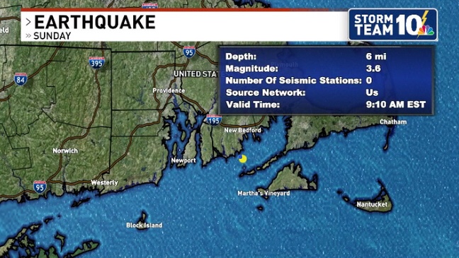
Did you feel it? At 9:10 am EST Sunday morning, a Magnitude 3.6 earthquake struck just south of Bliss Corner, Massachusetts, which is a census-designated place in Dartmouth. If you felt it, report it!
While minor earthquakes do happen from time to time in New England, tremors that are felt by a large number of people and that cause damage are rare.
Earthquake Report
The earthquake was originally measured as a magnitude 4.2 on the Richter scale by the United States Geological Surgey (USGS) before changing to a 3.6.
Earthquakes in New England and most places east of the Rocky Mountains are much different than the ones that occur along well-known fault lines in California and along the West Coast.
Rhode Island and Southeastern Massachusetts fall nearly in the center of the North American Plate, one of 15 (seven primary, eight secondary) that cover the Earth.
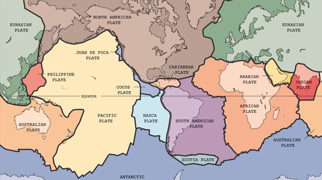
Earth’s tectonic plates
Tectonic plates move ever-so-slowly, and as they either push into each other, pull apart, or slide side-by-side, earthquakes are possible within the bedrock, usually miles deep.
Most of New England’s and Long Island’s bedrock was assembled as continents collided to form a supercontinent 500-300 million years ago, raising the northern Appalachian Mountains.
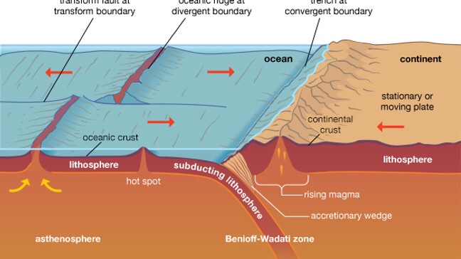
Plate tectonics (Courtesy: Encyclopaedia Britannica)
Fault lines left over from the creation of the Appalachian Mountains can still lead to earthquakes locally, and many faults remain undetected. According to the USGS, few, if any, earthquakes in New England can be linked to named faults.
While earthquakes in New England are generally much weaker compared to those on defined fault lines, their reach is still impressive. Sunday’s 3.6 was felt in Rhode Island, Massachusetts, Connecticut, New York, and New Hampshire.
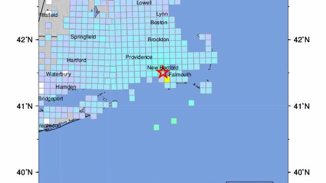
USGS Community Internet Intensity Map
While M 3.6 earthquakes rarely cause damage, some minor cracks were reported on social media from the shaking.
According to the USGS, moderately damaging earthquakes strike somewhere in the region every few decades, and smaller earthquakes are felt roughly twice a year.
The most recent New England earthquake to cause moderate damage occurred in 1940 (magnitude 5.6) in central New Hampshire.
No comments:
Post a Comment