At a Glance
Tropical Storm Beta is several hundred miles east of Brownsville, TX.
New warnings have been issued for portions of the Texas and Louisiana coasts.
This system may meander in the western Gulf the next several days.
This slow mover is a potential flood danger along the western Gulf Coast.
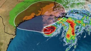
Tropical Storm Beta has stalled in the western Gulf of Mexico, which will eventually set the storm up for a slow scrape of the Texas coast into next week. Beta poses a major threat of rainfall and coastal flooding to the Texas and Louisiana coasts.
Beta’s formation is the 10th Atlantic named storm to form so far this month, which is the most on record for any September, according to Dr. Phil Klotzbach. September is typically the most active month of the hurricane season.
(MORE: 2020 Atlantic Hurricane Season is Now Using Greek Alphabet For Only the Second Time)
Current Alerts
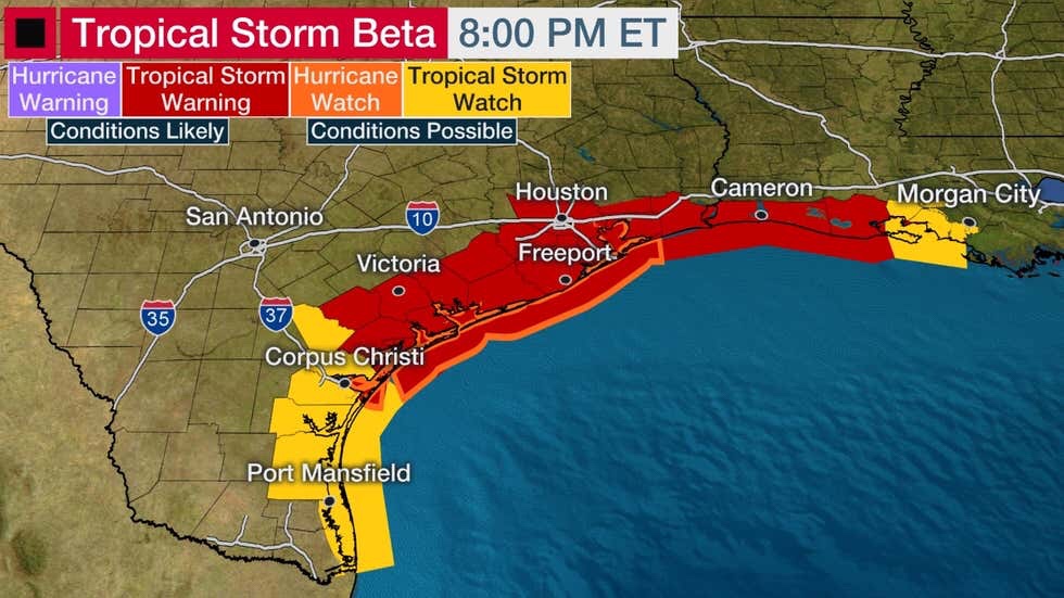
A storm surge warning is now in effect from Port Aransas, Texas to High Island, Texas including Copano Bay, Aransas Bay, San Antonio Bay, Matagorda Bay, and Galveston Bay.
A Hurricane Watch has been issued from Port Aransas, Texas to High Island, Texas, including Galveston. Hurricane conditions are possible in this area on Monday, with tropical storm conditions possible by late Sunday.
A tropical storm warning is now in effect from Port Aransas, Texas to Intracoastal City, Louisiana, including Houston and Victoria, Texas and Cameron, Louisiana. Tropical storm conditions are expected in this area by late Sunday.
A storm surge watch has been issued from Baffin Bay to Port Aransas in South Texas, including Baffin Bay and Corpus Christi Bay; and from High Island, Texas to Cameron, Louisiana, including Sabine Lake and Calcasieu Lake.
A tropical storm watch has been issued from south of Port Aransas to the Mouth of the Rio Grande and east of High Island to Morgan City, Louisiana. Tropical storm conditions are possible in this area by late Saturday.
Current Wind Watches and Warnings
Beta’s Forecast
With plenty of warm ocean water and lessening wind shear, this system is expected to intensify gradually through the weekend. Some dry air and wind shear are hindering Beta’s circulation this afternoon.
How strong it will become remains uncertain but is currently expected to become a hurricane. Water temperatures are very warm, which supports intensification, and wind shear should remain low to moderate, at most. However, it could be impacted by some dry air and it could eventually churn up enough cooler water below the surface to keep a lid on its intensification.
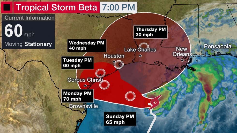
Current Storm Status and Projected Path
(The red-shaded area denotes the potential path of the center of the tropical cyclone. It’s important to note that impacts (particularly heavy rain, high surf, coastal flooding, winds) with any tropical cyclone usually spread beyond its forecast path.)
Beta’s center may hop around over the next few days as it tries to keep up with the thunderstorms that will power Beta into early next week. This will likely lead to jumps in the forecast left and right.
Even without the jumps in the forecast, this system has a number of twists and turns in its future.
First, a high pressure system setting up over the south-central U.S. has turned Beta westward at a slow pacr. This should be the most prevalent motion through the weekend and possibly into Monday.
After that, a dip in the jet stream and some lower pressures over the South may pick up Beta and take it northeastward by the middle part of next week, near or over the Texas or Louisiana coasts.
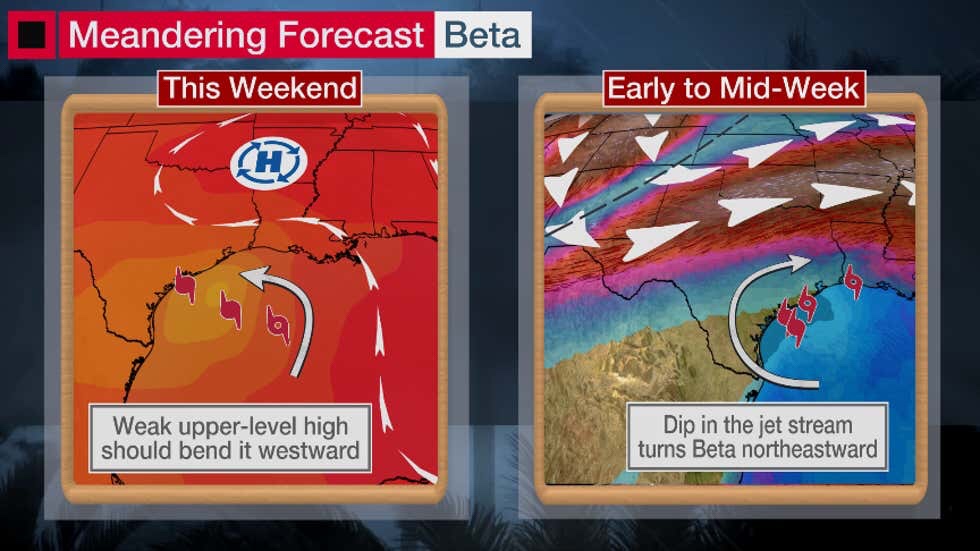
Steering Features
(Two big weather features will push Beta around in the northwestern Gulf over the next five days. )
Forecast Threats
Slow-moving tropical cyclones can be prolific rainfall producers, as we saw along the Gulf Coast and inland with Hurricane Sally.
Beta has been dropping light to moderate rainfall across southeastern Louisiana and southern portions of Mississippi and Alabama through much of Saturday. This plume of moisture may rotate westward or counter-clockwise through Louisiana and into Texas into Sunday.
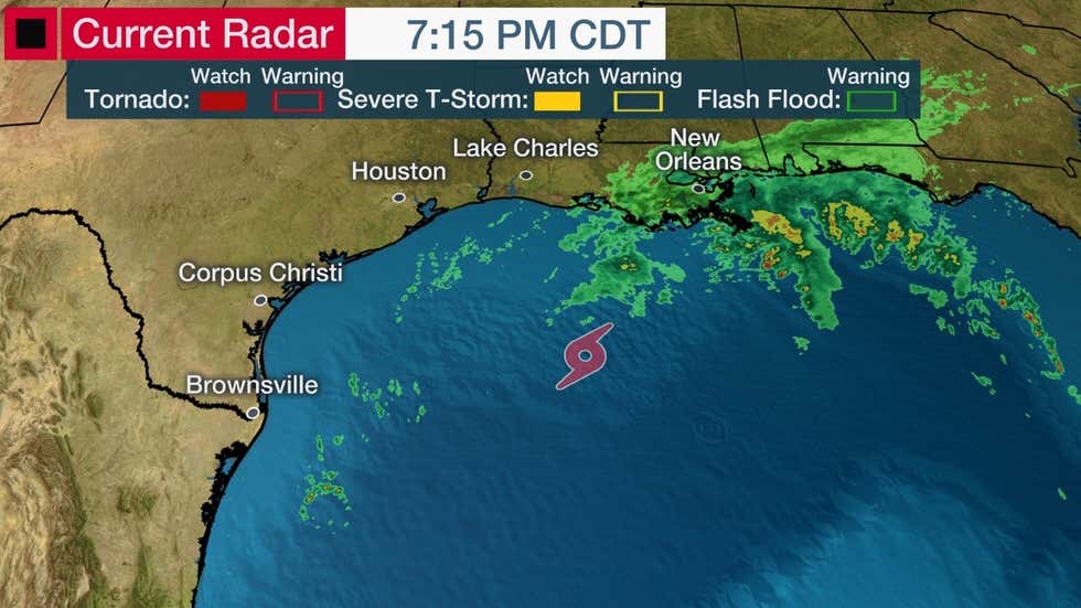
Current Radar
(Note: Radar returns in some areas may appear lower than reality due to the obliteration of the Lake Charles radar during Hurricane Laura. )
Beta is expected to be no exception, in fact, the National Hurricane Center doubled its earlier rainfall forecast.
(MORE: A Hurricane’s Forward Speeds Can Be As Important as Its Intensity)
Much of southern Louisiana and coastal Texas should expect 8-12 inches of rainfall with isolated totals up to 20 inches possible.
Given Beta’s slow movement, heavy rainfall and flooding is an increasing danger near the Texas coast and possibly the Louisiana coast through next week.
A flash flood watch has been issued for portions of southeastern Texas.
Given the numerous changes in forward direction and upper-level winds, the zone of heaviest rainfall will likely change from day to day.
This is not expected to produce rainfall that is anywhere comparable to Hurricane Harvey or Imelda.
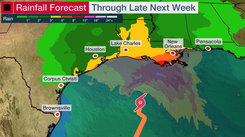
Rainfall Outlook
(This should be interpreted as a broad outlook of where the heaviest rain may fall.)
Increased surf and rip currents are also expected from northeastern Mexico to the northern Gulf Coast, beginning as soon as this weekend.
The National Weather Service notes that significant coastal flooding is possible on the middle and upper Texas coast through at least Tuesday morning, and coastal flooding might be possible in southeastern Louisiana and coastal Mississippi into early next week.
Persistent onshore flow and a possible storm surge component in combination with heavy rainfall could only worsen flooding near the coast into next week.
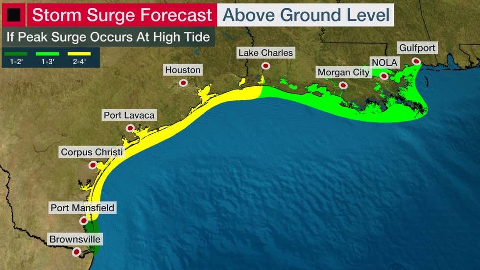
Here’s the current storm surge forecast from the National Hurricane Center:
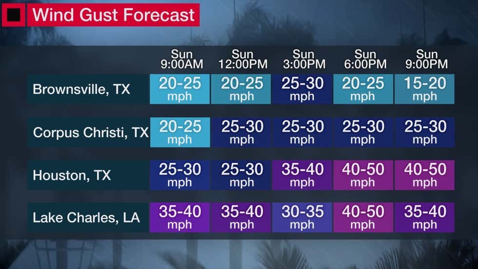
Gusty winds will begin by Sunday afternoon across much of the western and northern Gulf Coast.
Winds could reach tropical-storm-force by late Sunday along portions of the Texas Coast and parts of the southwestern Louisiana coast.
Exactly where the worst winds are going to come ashore is uncertain, but hurricane conditions are possible between Corpus Christi and Galveston late Monday.
A few tornadoes are also possible on the upper Texas Coast on Monday.
For now, all interests near the Texas and Louisiana Gulf Coasts should monitor closely the progress of this system and have their hurricane plans ready to go ahead of time in case it’s needed.
The Weather Company’s primary journalistic mission is to report on breaking weather news, the environment and the importance of science to our lives. This story does not necessarily represent the position of our parent company, IBM.
No comments:
Post a Comment