 5 p.m. — Teddy strengthens to Category 4 hurricane with 140 mph winds
The National Hurricane Center wrote Hurricane Teddy’s peak winds had increased 20 mph since the last advisory at 11 a.m., rapidly intensifying to a Category 4 hurricane with 140 mph maximum sustained winds. Some additional strengthening is possible tonight, and the Hurricane Center predicts its winds to peak around 150 mph before likely fluctuations in intensity into the weekend.
Original article from midday
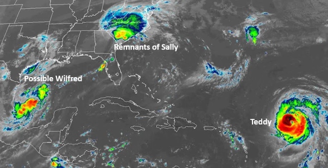
After Hurricane Sally unloaded 20 to 30 inches of rain, unleashing wind gusts over 100 mph and generating a six-foot storm surge along the Florida Panhandle and Alabama coast, its remnants are marching through the Southeast, dumping more flooding rain. But, reflecting the breakneck pace of the 2020 Atlantic hurricane season, forecasters are already turning their attention to two more threatening tropical weather systems: Hurricane Teddy and a disturbance in the Gulf of Mexico that could soon earn the name Wilfred.
There is some chance Teddy could strike Bermuda and then northern New England toward the middle of next week, while the gulf system could be a problem for coastal Texas and the northern Gulf Coast around the same time.
The threat of new storms comes during the busiest Atlantic hurricane season on record. Twenty named storms have formed and, after the likely Wilfred, forecasters will be forced to draw from the Greek alphabet for naming additional storms. That’s happened only once before, in 2005, the busiest season on record.
Running out of hurricane names, we’ll soon switch to the Greek alphabet. That could present a problem.
Sally

Rainfall forecast for Sally’s remnants from the National Weather Service.
Once formidable, Sally was downgraded to a remnant area of low pressure Thursday morning, and the National Hurricane Center issued its final advisory on the system at 5 a.m.
Centered over Georgia, the former hurricane was picking up speed, heading toward the Carolinas at 12 mph.
Flash-flood watches spanned from northeast Georgia through western South Carolina, much of North Carolina and southeastern Virginia, with widespread rainfall of two to four inches predicted with amounts in some places topping six inches. The southern Delmarva Peninsula could also see that much rain. This entire zone was under a slight to moderate risk of flash flooding.
In a special bulletin, the National Weather Service wrote that central South Carolina, in particular, was experiencing heavy rainfall, at rates of one to two inches per hour. “The expected intensity and duration of this rainfall will cause flash flooding, particularly across central SC where the highest amounts are expected through [4 p.m. Thursday],” it wrote. “Some of it could [be] significant on any sensitive or urban locations.”
East of where the center tracks, some tornadoes were possible. A tornado watch was in effect until 6 p.m. in central and eastern South Carolina.
Gusts to 123 mph, 30 inches of rain and a 6-foot storm surge: Hurricane Sally by the numbers
Hurricane Teddy gains ‘major’ status
On Thursday morning, Hurricane Teddy intensified into a major Category 3 hurricane, with peak sustained winds of 120 mph. Positioned 1,155 miles southeast of Bermuda, it was sweeping northwestward at 12 mph. The storm is forecast to intensify further, attaining winds of 130 mph by Thursday night, which would make it a Category 4 storm.
By the weekend and early next week, Teddy is predicted to encounter cooler waters and an increase in hostile high-altitude winds, which would cause it to weaken slightly. Nevertheless, by Monday, when it will be making its closest pass to Bermuda, it is still expected to be a Category 2 hurricane with winds over 100 mph.
“While the exact details of Teddy’s track and intensity near the island are not yet known, the risk of strong winds, storm surge, and heavy rainfall on Bermuda is increasing,” the Hurricane Center wrote.
Teddy could be the second hurricane to strike Bermuda in the same week. This past Monday, Hurricane Paulette passed directly over the island.
After Teddy passes Bermuda, some models suggest high pressure over the North Atlantic could force it to make a rare, hard left turn toward Maine or the Canadian Maritimes, while others suggest it will curl away, remaining over the ocean. Any effects to North America are likely at least five or six days away, if this happens. Regardless, the storm is likely to generate large ocean swells and rip currents along the East Coast.
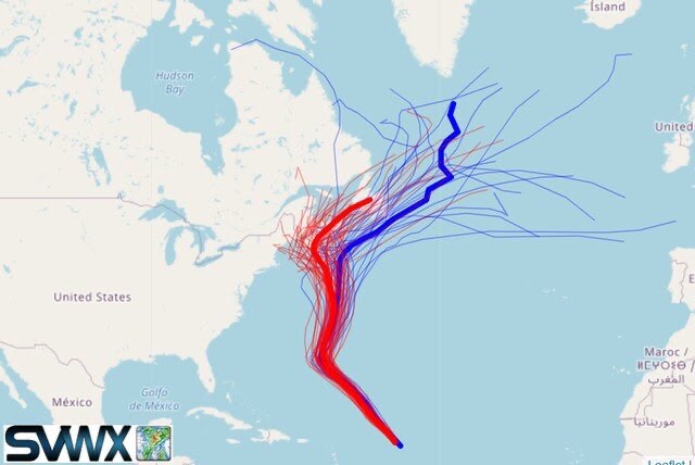
Simulations from American (blue) and European (red) computer models from Thursday for Hurricane Teddy’s track. The bold lines represent the average forecast from each simulation group. (StormVistaWxModels)
Teddy is the second major hurricane, rated Category 3 or higher, to form in 2020, following Hurricane Laura.
System forming in the Gulf of Mexico
The Hurricane Center wrote Thursday morning that an area of disturbed weather over the southwest Gulf of Mexico is becoming better organized. “Upper-level winds are gradually becoming more conducive for development and, if this recent development trend continues, a tropical depression or a tropical storm could form later today,” it wrote.
It is likely this system will become Tropical Storm Wilfred. Through Friday, it is not expected to move much before slowly drifting to the north and northeast over the weekend. By early next week, it could be close to the South Texas coast. Beyond that, computer models project it will continue north and northeastward and may approach the northern Gulf Coast on Wednesday and Thursday.

Rainfall predicted by European modeling system over the next week in the Gulf of Mexico. (WeatherBell)
It is too soon to predict specifically what land areas this potential storm could brush or strike directly, or its intensity. But, because of its slow movement, it may pose yet another heavy rainfall threat for portions of the western and northern Gulf Coast. And, if it’s able to gain strength, a threat from storm surge and high winds could emerge as well.
Other systems under investigation
In addition to the remnants of Sally, Hurricane Teddy and the gulf system, the Hurricane Center was monitoring three other systems:
• Vicky, a tropical depression in the eastern Atlantic, was forecast to dissipate.
• A disturbance southwest of the Cabo Verde Islands has a 50 percent chance to develop into a tropical depression or storm over the next five days as it heads eastward. It could be 2020′s first storm to be named from the Greek alphabet: Alpha.
• A disturbance in the far northeastern Atlantic several hundred miles east of the Azores has been given a 30 percent chance to develop. “The system is expected to reach the coast of Portugal late Friday,” the Hurricane Center wrote.
No comments:
Post a Comment