Tropical Storm Beta Brings Threats of Flooding Rainfall and Storm Surge to Texas, Louisiana
Tropical Storm Beta Brings Heavy Rain and Flood Threat To Texas and Louisiana
At a Glance
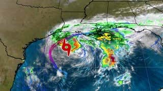
Tropical Storm Beta is tracking through the northwest Gulf of Mexico.
Beta will make landfall on the Texas coast on Monday or Monday night.
The storm will pose a threat of flooding rainfall through the first half of this week in parts of Texas and Louisiana.
Minor to locally moderate coastal flooding is occurring on the Texas coast.
Tropical-storm-force winds will affect parts of coastal Louisiana and Texas through Monday.
Current Alerts
A tropical storm warning is in effect from Port Aransas, Texas, to Morgan City, Louisiana, including Houston and Victoria, Texas, and Cameron, Louisiana. Tropical storm conditions (winds 39 mph or greater) are already occurring in parts of southwestern Louisiana, and those winds will spread into the warning areas along the Texas coast by later Sunday or early Monday.
A storm surge warning is also in effect from Port Aransas, Texas, to the Rockefeller Wildlife Refuge, Louisiana, including Copano Bay, Aransas Bay, San Antonio Bay, Matagorda Bay, Galveston Bay, Sabine Lake and Lake Calcasieu.
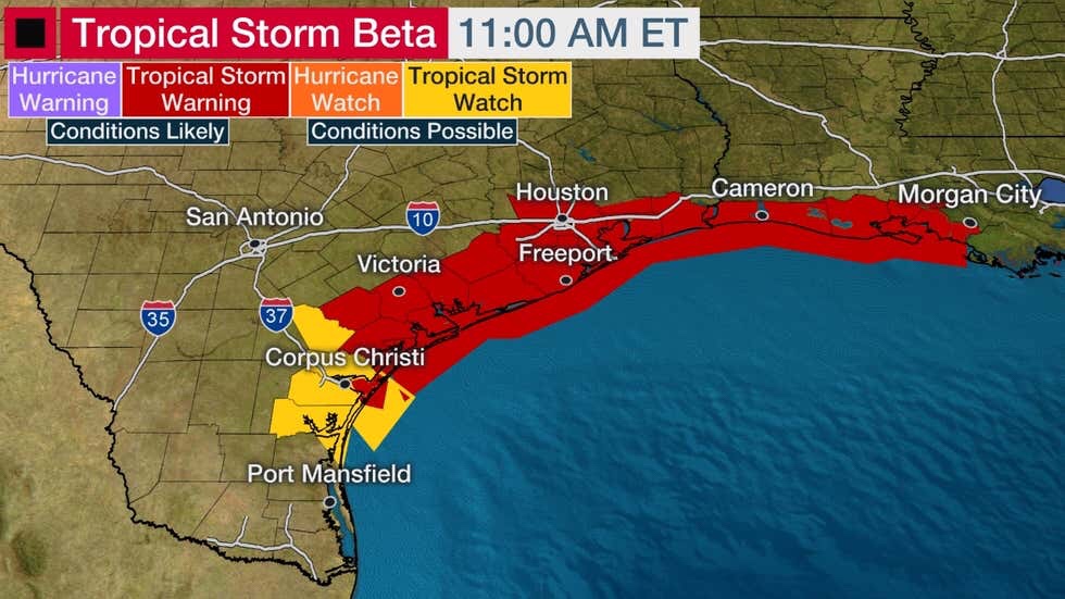
Current Wind Watches and Warnings
Happening Now
Showers and thunderstorms from Beta are affecting parts of coastal Louisiana and Texas right now.
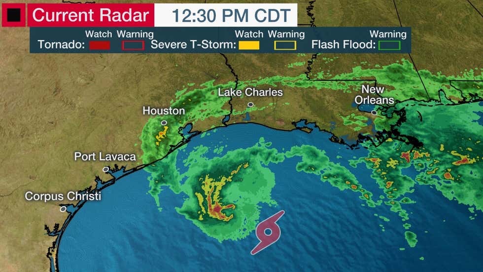
Current Radar
(Note: Radar returns in some areas may appear lower than reality due to the obliteration of the Lake Charles radar during Hurricane Laura. )
Portions of the Texas coast in the storm surge warning area have been experiencing minor to locally moderate coastal flooding since Saturday.
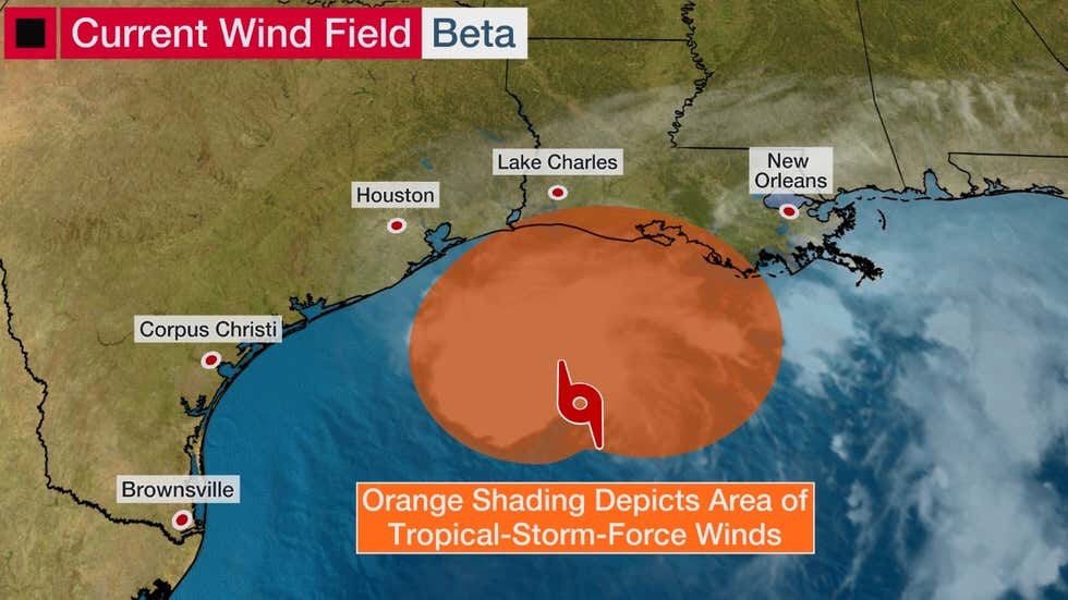
Beta’s tropical-storm-force winds extend out up to 195 miles from the storm’s center. Those winds are mostly located to the north of Beta’s circulation center, as depicted in the map below.
Forecast Track and Intensity
Beta is forecast to track steadily to the west-northwest through Monday toward the middle and upper Texas coastline.
The storm is expected to battle dry air and wind shear, which will prevent any significant intensification from occurring before the storm makes landfall. Beta is no longer expected to become a hurricane prior to landfall.
Landfall of Beta’s center on the Texas coast should occur sometime during the second half of Monday. However, impacts like rainfall and coastal flooding are arriving well in advance of that.
After Beta makes landfall, the system is expected to curl slowly north and then northeast toward the lower Mississippi Valley, with areas of heavy rainfall continuing through the first half of this week.
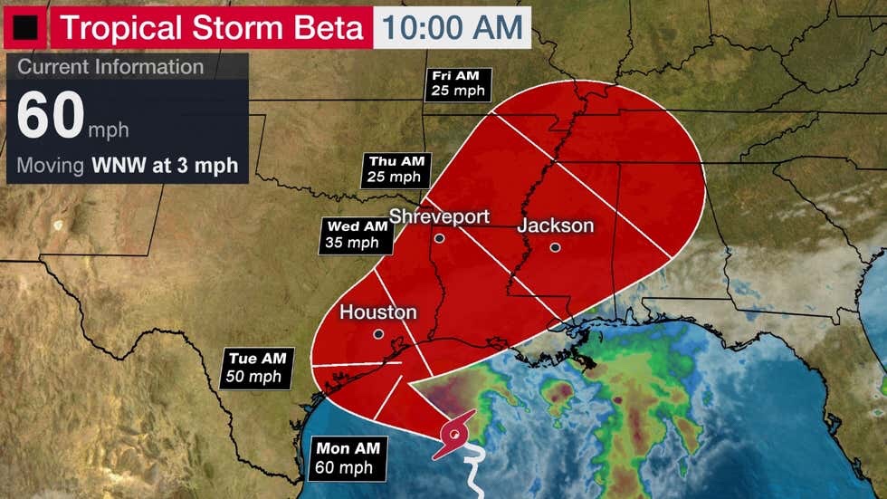
Current Storm Status and Projected Path
(The red-shaded area denotes the potential path of the center of the tropical cyclone. It’s important to note that impacts (particularly heavy rain, high surf, coastal flooding, winds) with any tropical cyclone usually spread beyond its forecast path.)
Forecast Impacts
Flooding Rainfall
Beta is a slow-moving storm, and that means it poses a significant threat of flooding rainfall.
Areas from southern Louisiana and the middle and upper Texas coast could see 8 to 12 inches of rainfall, with isolated totals up to 20 inches possible, according to the National Hurricane Center (NHC). There could be localized rainfall totals of 4 to 8 inches farther inland from the coast across parts of eastern Texas and Louisiana into the lower Mississippi Valley into midweek.
Flash flooding and urban flooding will impact some of these areas and there could river flooding as well, according to the NHC.
Some of Beta’s rainfall could fall on areas where the soil is saturated from Laura’s heavy rain weeks ago in Louisiana, northeast Texas, southeast Oklahoma and Arkansas.
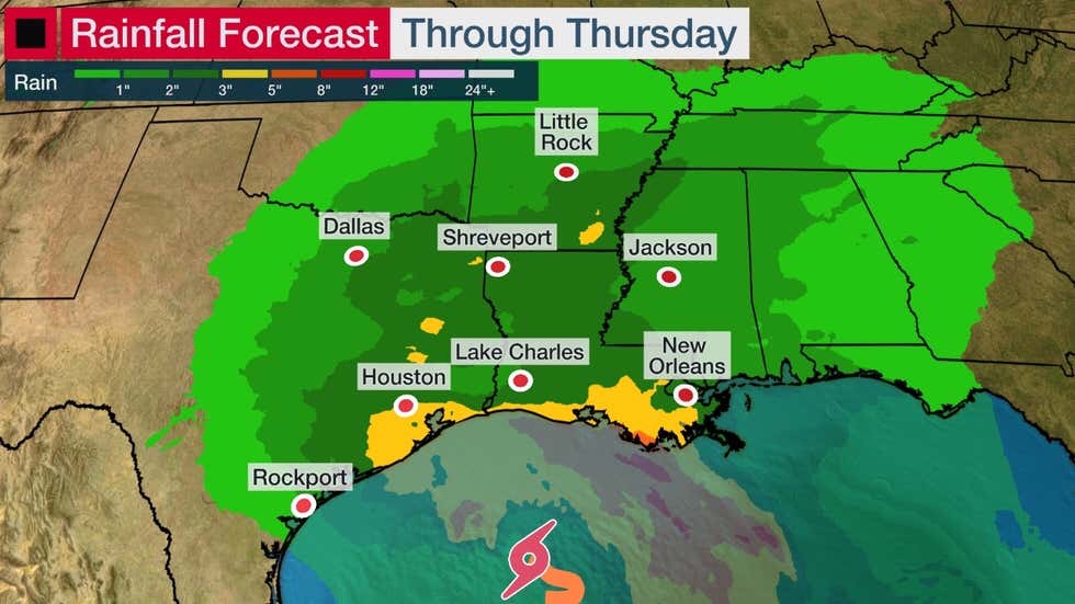
Rainfall Forecast
(Locally heavier rainfall is possible in some areas.)
A flash flood watch has been issued for portions of southeastern Texas, including Houston.
Beta is not expected to produce rainfall that is anywhere comparable to Hurricane Harvey (2017) or Tropical Storm Imelda (2019).
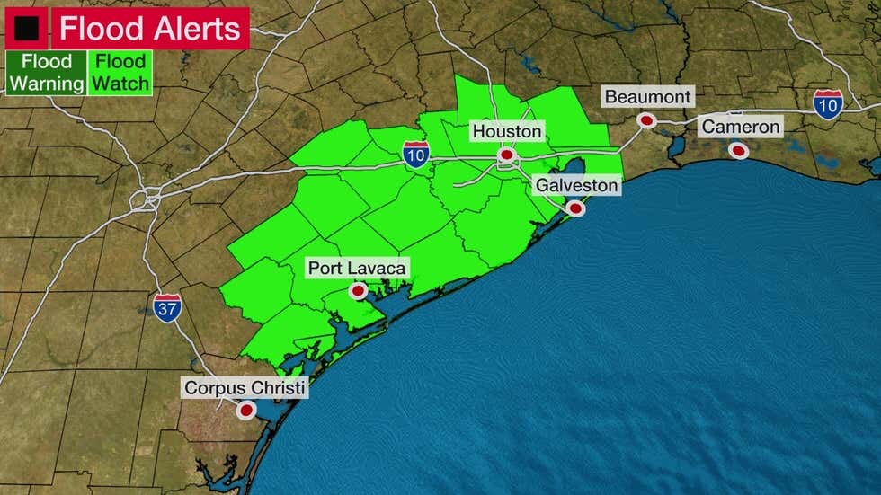
Flood Alerts
(From the National Weather Service.)
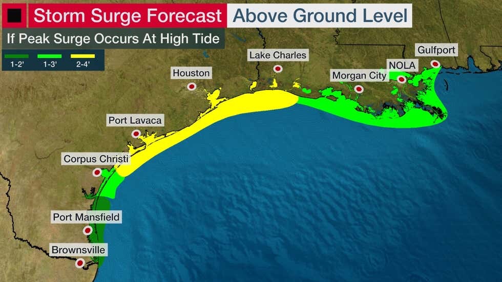
Storm Surge
Minor to locally moderate coastal flooding from Beta has already occurred along parts of the Texas coast.
The National Hurricane Center (NHC) notes that there is a danger of life-threatening storm surge near times of high tide through Tuesday morning in the storm surge warning area of Texas and Louisiana.
Storm surge in combination with heavy rainfall could only worsen flooding near the coast early this week.
Here’s the current storm surge forecast from the NHC, if the peak surge occurs at times of high tide.
 ea
ea
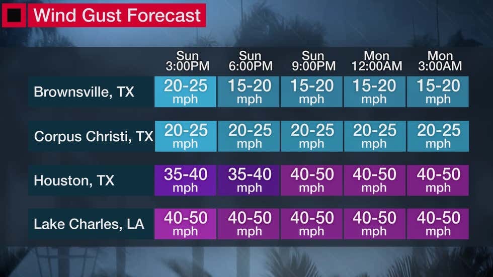
Winds
Tropical-storm-force winds are already occurring in southwest Louisiana. These stronger winds will spread toward coastal Texas later Sunday through early Monday.
The winds could trigger sporadic power outages and might down some trees, particularly in areas where the soil becomes saturated from heavy rainfall.
Tornadoes
A few tornadoes are also possible on the upper Texas Coast and in southwest Lousiana on Monday.
The Weather Company’s primary journalistic mission is to report on breaking weather news, the environment and the importance of science to our lives. This story does not necessarily represent the position of our parent company, IBM.
No comments:
Post a Comment