Friday, September 30, 2022

Real Risk, Few Precautions (Revelation 6:12)

          By WILLIAM K. STEVENS

Published: October 24, 1989
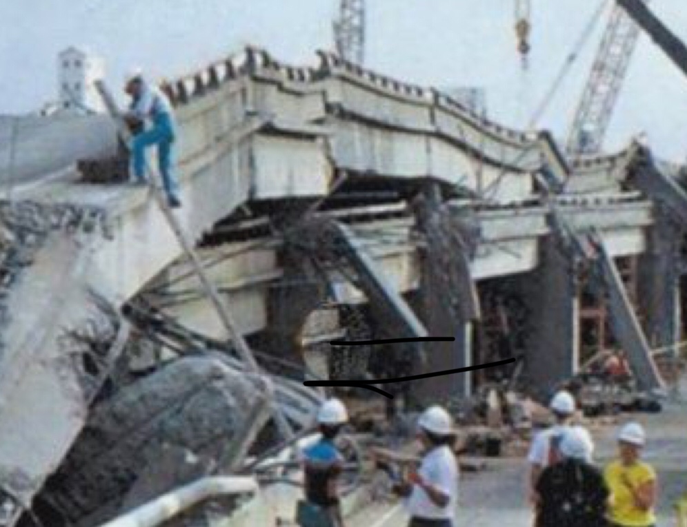
AN EARTHQUAKE as powerful as the one that struck northern California last week could occur almost anywhere along the East Coast, experts say. And if it did, it would probably cause far more destruction than the West Coast quake.
The chances of such an occurrence are much less in the East than on the West Coast. Geologic stresses in the East build up only a hundredth to a thousandth as fast as in California, and this means that big Eastern quakes are far less frequent. Scientists do not really know what the interval between them might be, nor are the deeper-lying geologic faults that cause them as accessible to study. So seismologists are at a loss to predict when or where they will strike.
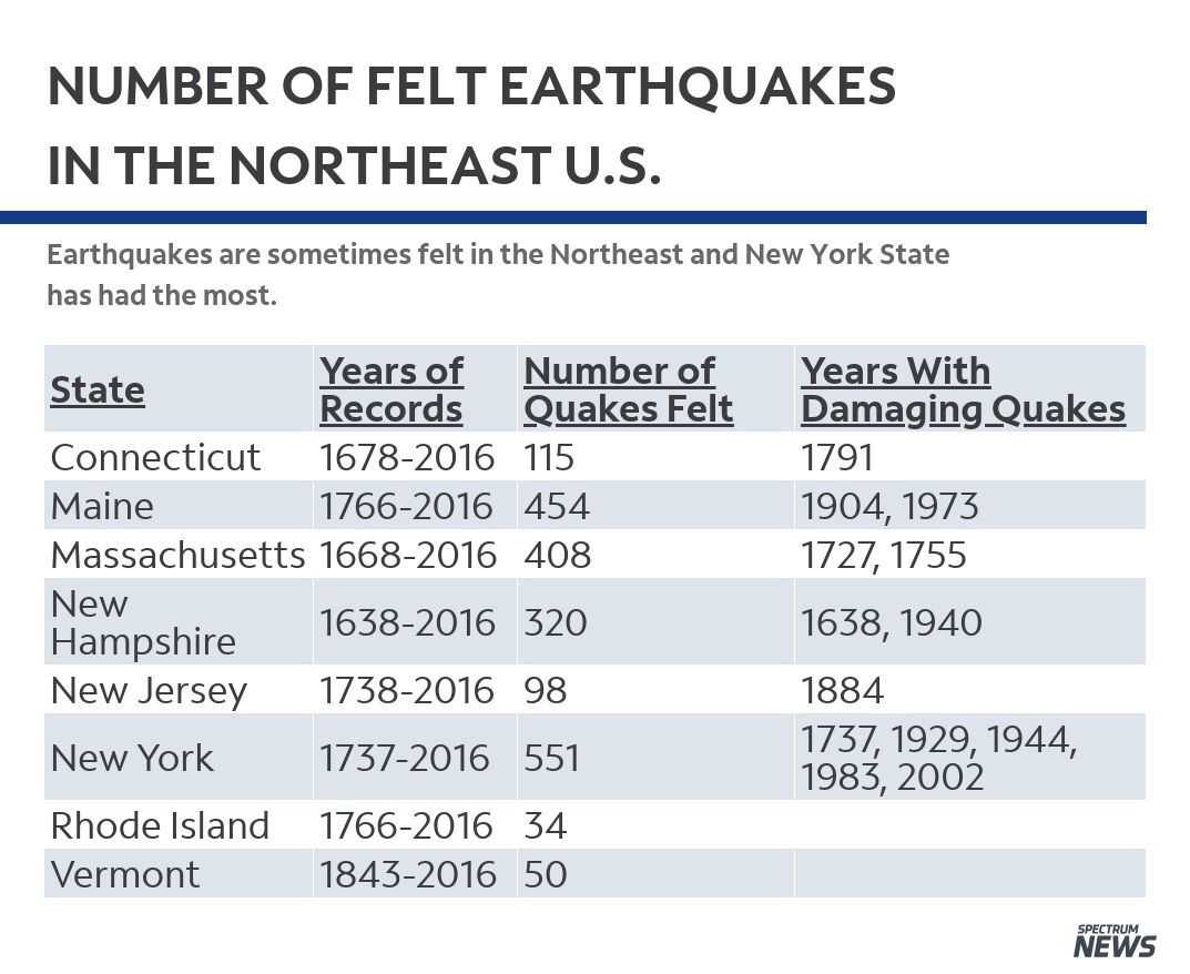
But they do know that a temblor with a magnitude estimated at 7 on the Richter scale – about the same magnitude as last week’s California quake – devastated Charleston, S.C., in 1886. And after more than a decade of study, they also know that geologic structures similar to those that caused the Charleston quake exist all along the Eastern Seaboard.
For this reason, ”we can’t preclude that a Charleston-sized earthquake might occur anywhere along the East Coast,” said David Russ, the assistant chief geologist of the United States Geological Survey in Reston, Va. ”It could occur in Washington. It could occur in New York.”
If that happens, many experts agree, the impact will probably be much greater than in California.Easterners, unlike Californians, have paid very little attention to making buildings and other structures earthquake-proof or earthquake-resistant. ”We don’t have that mentality here on the East Coast,” said Robert Silman, a New York structural engineer whose firm has worked on 3,800 buildings in the metropolitan area.
Moreover, buildings, highways, bridges, water and sewer systems and communications networks in the East are all older than in the West and consequently more vulnerable to damage. Even under normal conditions, for instance, water mains routinely rupture in New York City.
The result, said Dr. John Ebel, a geophysicist who is the assistant director of Boston College’s Weston Observatory, is that damage in the East would probably be more widespread, more people could be hurt and killed, depending on circumstances like time of day, and ”it would probably take a lot longer to get these cities back to useful operating levels.”
On top of this, scientists say, an earthquake in the East can shake an area 100 times larger than a quake of the same magnitude in California. This is because the earth’s crust is older, colder and more brittle in the East and tends to transmit seismic energy more efficiently. ”If you had a magnitude 7 earthquake and you put it halfway between New York City and Boston,” Dr. Ebel said, ”you would have the potential of doing damage in both places,” not to mention cities like Hartford and Providence.
Few studies have been done of Eastern cities’ vulnerability to earthquakes. But one, published last June in The Annals of the New York Academy of Sciences, calculated the effects on New York City of a magnitude 6 earthquake. That is one-tenth the magnitude of last week’s California quake, but about the same as the Whittier, Calif., quake two years ago.
The study found that such an earthquake centered 17 miles southeast of City Hall, off Rockaway Beach, would cause $11 billion in damage to buildings and start 130 fires. By comparison, preliminary estimates place the damage in last week’s California disaster at $4 billion to $10 billion. If the quake’s epicenter were 11 miles southeast of City Hall, the study found, there would be about $18 billion in damage; if 5 miles, about $25 billion.
No estimates on injuries or loss of life were made. But a magnitude 6 earthquake ”would probably be a disaster unparalleled in New York history,” wrote the authors of the study, Charles Scawthorn and Stephen K. Harris of EQE Engineering in San Francisco.
The study was financed by the National Center for Earthquake Engineering Research at the State University of New York at Buffalo. The research and education center, supported by the National Science Foundation and New York State, was established in 1986 to help reduce damage and loss of life from earthquakes.
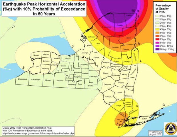
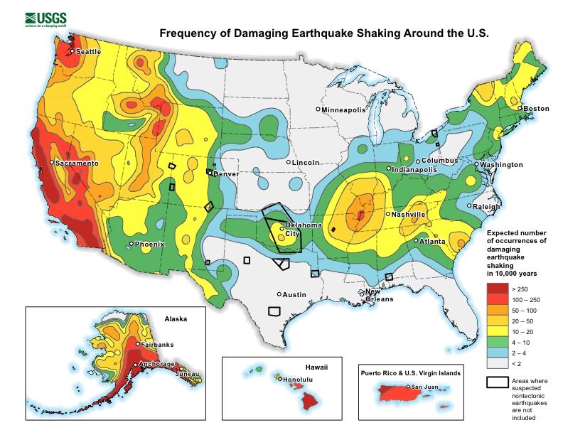
The study’s postulated epicenter of 17 miles southeast of City Hall was the location of the strongest quake to strike New York since it has been settled, a magnitude 5 temblor on Aug. 10, 1884. That 1884 quake rattled bottles and crockery in Manhattan and frightened New Yorkers, but caused little damage. Seismologists say a quake of that order is likely to occur within 50 miles of New York City every 300 years. Quakes of magnitude 5 are not rare in the East. The major earthquake zone in the eastern half of the country is the central Mississippi Valley, where a huge underground rift causes frequent geologic dislocations and small temblors. The most powerful quake ever known to strike the United States occurred at New Madrid, Mo., in 1812. It was later estimated at magnitude 8.7 and was one of three quakes to strike that area in 1811-12, all of them stronger than magnitude 8. They were felt as far away as Washington, where they rattled chandeliers, Boston and Quebec.
Because the New Madrid rift is so active, it has been well studied, and scientists have been able to come up with predictions for the central Mississippi valley, which includes St. Louis and Memphis. According to Dr. Russ, there is a 40 to 63 percent chance that a quake of magnitude 6 will strike that area between now and the year 2000, and an 86 to 97 percent chance that it will do so by 2035. The Federal geologists say there is a 1 percent chance or less of a quake greater than magnitude 7 by 2000, and a 4 percent chance or less by 2035.
Elsewhere in the East, scientists are limited in their knowledge of probabilities partly because faults that could cause big earthquakes are buried deeper in the earth’s crust. In contrast to California, where the boundary between two major tectonic plates creates the San Andreas and related faults, the eastern United States lies in the middle of a major tectonic plate. Its faults are far less obvious, their activity far more subtle, and their slippage far slower. 
Any large earthquake would be ”vastly more serious” in the older cities of the East than in California,  said Dr. Tsu T. Soong, a professor of civil engineering at the State University of New York at Buffalo who is a researcher in earthquake-mitigation technology at the National Center for Earthquake Engineering Research. First, he said, many buildings are simply older, and therefore weaker and more  vulnerable to collapse. Second, there is no seismic construction code in most of the East as there is in California, where such codes have been in place for decades.
The vulnerability is evident in many ways. ”I’m sitting here looking out my window,” said Mr. Silman, the structural engineer in New York, ”and I see a bunch of water tanks all over the place” on rooftops. ”They are not anchored down at all, and it’s very possible they would fall in an earthquake.”
 Many brownstones, he said, constructed as they are of unreinforced masonry walls with wood joists between, ”would just go like a house of cards.” Unreinforced masonry, in fact, is the single most vulnerable structure, engineers say. Such buildings are abundant, even predominant, in many older cities. The Scawthorn-Harris study reviewed inventories of all buildings in Manhattan as of 1972 and found that 28,884, or more than half, were built of unreinforced masonry. Of those, 23,064 were three to five stories high.
Buildings of reinforced masonry, reinforced concrete and steel would hold up much better, engineers say, and wooden structures are considered intrinsically tough in ordinary circumstances. The best performers, they say, would probably be skyscrapers built in the last 20 years. As Mr. Silman explained, they have been built to withstand high winds, and the same structural features that enable them to do so also help them resist an earthquake’s force. But even these new towers have not been provided with the seismic protections required in California and so are more vulnerable than similar structures on the West Coast.
Buildings in New York are not generally constructed with such seismic protections as base-isolated structures, in which the building is allowed to shift with the ground movement; or with flexible frames that absorb and distribute energy through columns and beams so that floors can flex from side to side, or with reinforced frames that help resist distortion.
”If you’re trying to make a building ductile – able to absorb energy – we’re not geared to think that way,” said Mr. Silman.
New York buildings also contain a lot of decorative stonework, which can be dislodged and turned into lethal missiles by an earthquake. In California, building codes strictly regulate such architectural details.
Manhattan does, however, have at least one mitigating factor: ”We are blessed with this bedrock island,” said Mr. Silman. ”That should work to our benefit; we don’t have shifting soils. But there are plenty of places that are problem areas, particularly the shoreline areas,” where landfills make the ground soft and unstable.
As scientists have learned more about geologic faults in the Northeast, the nation’s uniform building code – the basic, minimum code followed throughout the country – has been revised accordingly. Until recently, the code required newly constructed buildings in New York City to withstand at least 19 percent of the side-to-side seismic force that a comparable building in the seismically active areas of California must handle. Now the threshold has been raised to 25 percent.
New York City, for the first time, is moving to adopt seismic standards as part of its own building code. Local and state building codes can and do go beyond the national code. Charles M. Smith Jr., the city Building Commissioner, last spring formed a committee of scientists, engineers, architects and government officials to recommend the changes.
”They all agree that New York City should anticipate an earthquake,” Mr. Smith said. As to how big an earthquake, ”I don’t think anybody would bet on a magnitude greater than 6.5,” he said. ”I don’t know,” he added, ”that our committee will go so far as to acknowledge” the damage levels in the Scawthorn-Harris study, characterizing it as ”not without controversy.”
For the most part, neither New York nor any other Eastern city has done a detailed survey of just how individual buildings and other structures would be affected, and how or whether to modify them.
”The thing I think is needed in the East is a program to investigate all the bridges” to see how they would stand up to various magnitudes of earthquake,” said Bill Geyer, the executive vice president of the New York engineering firm of Steinman, Boynton, Gronquist and Birdsall, which is rehabilitating the cable on the Williamsburg Bridge. ”No one has gone through and done any analysis of the existing bridges.”
In general, he said, the large suspension bridges, by their nature, ”are not susceptible to the magnitude of earthquake you’d expect in the East.” But the approaches and side spans of some of them might be, he said, and only a bridge-by-bridge analysis would tell. Nor, experts say, are some elevated highways in New York designed with the flexibility and ability to accommodate motion that would enable them to withstand a big temblor.
Tunnels Vulnerable
The underground tunnels that carry travelers under the rivers into Manhattan, those that contain the subways and those that carry water, sewers and natural gas would all be vulnerable to rupture, engineers say. The Lincoln, Holland, PATH and Amtrak tunnels, for instance, go from bedrock in Manhattan to soft soil under the Hudson River to bedrock again in New Jersey, said Mark Carter, a partner in Raamot Associates, geotechnical engineers specializing in soils and foundations.
Likewise, he said, subway tunnels between Manhattan and Queens go from hard rock to soft soil to hard rock on Roosevelt Island, to soft soil again and back to rock. The boundaries between soft soil and rock are points of weakness, he said.
”These structures are old,” he said, ”and as far as I know they have not been designed for earthquake loadings.”
Even if it is possible to survey all major buildings and facilities to determine what corrections can be made, cities like New York would then face a major decision: Is it worth spending the money to modify buildings and other structures to cope with a quake that might or might not come in 100, or 200 300 years or more?
”That is a classical problem” in risk-benefit analysis, said Dr. George Lee, the acting director of the Earthquake Engineering Research Center in Buffalo. As more is learned about Eastern earthquakes, he said, it should become ”possible to talk about decision-making.” But for now, he said, ”I think it’s premature for us to consider that question.”

Thursday, September 29, 2022

The Sixth Seal Is Long Overdue (Revelation 6:12)


By MARGO NASH
Published: March 25, 2001
Alexander Gates, a geology professor at Rutgers-Newark, is co-author of ”The Encyclopedia of Earthquakes and Volcanoes,” which will be published by Facts on File in July. He has been leading a four-year effort to remap an area known as the Sloatsburg Quadrangle, a 5-by-7-mile tract near Mahwah that crosses into New York State. The Ramapo Fault, which runs through it, was responsible for a big earthquake in 1884, and Dr. Gates warns that a recurrence is overdue. He recently talked about his findings.
Q. What have you found?
A. We’re basically looking at a lot more rock, and we’re looking at the fracturing and jointing in the bedrock and putting it on the maps. Any break in the rock is a fracture. If it has movement, then it’s a fault. There are a lot of faults that are offshoots of the Ramapo. Basically when there are faults, it means you had an earthquake that made it. So there was a lot of earthquake activity to produce these features. We are basically not in a period of earthquake activity along the Ramapo Fault now, but we can see that about six or seven times in history, about 250 million years ago, it had major earthquake activity. And because it’s such a fundamental zone of weakness, anytime anything happens, the Ramapo Fault goes.
Q. Where is the Ramapo Fault?
 A. The fault line is in western New Jersey and goes through a good chunk of the state, all the way down to Flemington. It goes right along where they put in the new 287. It continues northeast across the Hudson River right under the Indian Point power plant up into Westchester County. There are a lot of earthquakes rumbling around it every year, but not a big one for a while.
Q. Did you find anything that surprised you?
A. I found a lot of faults, splays that offshoot from the Ramapo that go 5 to 10 miles away from the fault. I have looked at the Ramapo Fault in other places too. I have seen splays 5 to 10 miles up into the Hudson Highlands. And you can see them right along the roadsides on 287. There’s been a lot of damage to those rocks, and obviously it was produced by fault activities. All of these faults have earthquake potential.
Q. Describe the 1884 earthquake.
A. It was in the northern part of the state near the Sloatsburg area. They didn’t have precise ways of describing the location then. There was lots of damage. Chimneys toppled over. But in 1884, it was a farming community, and there were not many people to be injured. Nobody appears to have written an account of the numbers who were injured.
Q. What lessons we can learn from previous earthquakes?
A. In 1960, the city of Agadir in Morocco had a 6.2 earthquake that killed 12,000 people, a third of the population, and injured a third more. I think it was because the city was unprepared.There had been an earthquake in the area 200 years before. But people discounted the possibility of a recurrence. Here in New Jersey, we should not make the same mistake. We should not forget that we had a 5.4 earthquake 117 years ago. The recurrence interval for an earthquake of that magnitude is every 50 years, and we are overdue. The Agadir was a 6.2, and a 5.4 to a 6.2 isn’t that big a jump.
Q. What are the dangers of a quake that size?
A. When you’re in a flat area in a wooden house it’s obviously not as dangerous, although it could cut off a gas line that could explode. There’s a real problem with infrastructure that is crumbling, like the bridges with crumbling cement.There’s a real danger we could wind up with our water supplies and electricity cut off if a sizable earthquake goes off. The best thing is to have regular upkeep and keep up new building codes. The new buildings will be O.K. But there is a sense of complacency.
MARGO NASH

Wednesday, September 28, 2022

New York Earthquake: City of the Sixth Seal (Revelation 6:12)


New York earthquake: City at risk of ‚dangerous shaking from far away‘
Joshua Nevett
Published 30th April 2018
SOME of New York City’s tallest skyscrapers are at risk of being shaken by seismic waves triggered by powerful earthquakes from miles outside the city, a natural disaster expert has warned.
Researchers believe that a powerful earthquake, magnitude 5 or greater, could cause significant damage to large swathes of NYC, a densely populated area dominated by tall buildings.
A series of large fault lines that run underneath NYC’s five boroughs, Manhattan, Brooklyn, Queens, The Bronx and Staten Island, are capable of triggering large earthquakes.
Some experts have suggested that NYC is susceptible to at least a magnitude 5 earthquake once every 100 years.
The last major earthquake measuring over magnitude 5.0 struck NYC in 1884 – meaning another one of equal size is “overdue” by 34 years, according their prediction model.
Natural disaster researcher Simon Day, of University College London, agrees with the conclusion that NYC may be more at risk from earthquakes than is usually thought.
EARTHQUAKE RISK: New York is susceptible to seismic shaking from far-away tremors
But the idea of NYC being “overdue” for an earthquake is “invalid”, not least because the “very large number of faults” in the city have individually low rates of activity, he said.
The model that predicts strong earthquakes based on timescale and stress build-up on a given fault has been “discredited”, he said.
What scientists should be focusing on, he said, is the threat of large and potentially destructive earthquakes from “much greater distances”.
The dangerous effects of powerful earthquakes from further away should be an “important feature” of any seismic risk assessment of NYC, Dr Day said.

GETTY
THE BIG APPLE: An aerial view of Lower Manhattan at dusk in New York City

USGS
RISK: A seismic hazard map of New York produced by USGS
“New York is susceptible to seismic shaking from earthquakes at much greater distances” Dr Simon Day, natural disaster researcher
This is because the bedrock underneath parts of NYC, including Long Island and Staten Island, cannot effectively absorb the seismic waves produced by earthquakes.
“An important feature of the central and eastern United States is, because the crust there is old and cold, and contains few recent fractures that can absorb seismic waves, the rate of seismic reduction is low.
Central regions of NYC, including Manhattan, are built upon solid granite bedrock; therefore the amplification of seismic waves that can shake buildings is low.
But more peripheral areas, such as Staten Island and Long Island, are formed by weak sediments, meaning seismic hazard in these areas is “very likely to be higher”, Dr Day said.
“Thus, like other cities in the eastern US, New York is susceptible to seismic shaking from earthquakes at much greater distances than is the case for cities on plate boundaries such as Tokyo or San Francisco, where the crustal rocks are more fractured and absorb seismic waves more efficiently over long distances,” Dr Day said.
In the event of a large earthquake, dozens of skyscrapers, including Chrysler Building, the Woolworth Building and 40 Wall Street, could be at risk of shaking.
“The felt shaking in New York from the Virginia earthquake in 2011 is one example,” Dr Day said.
On that occasion, a magnitude 5.8 earthquake centered 340 miles south of New York sent thousands of people running out of swaying office buildings.

USGS
FISSURES: Fault lines in New York City have low rates of activity, Dr Day said
NYC Mayor Michael Bloomberg said the city was “lucky to avoid any major harm” as a result of the quake, whose epicenter was near Louisa, Virginia, about 40 miles from Richmond.
“But an even more impressive one is the felt shaking from the 1811-1812 New Madrid earthquakes in the central Mississippi valley, which was felt in many places across a region, including cities as far apart as Detroit, Washington DC and New Orleans, and in a few places even further afield including,” Dr Day added.
“So, if one was to attempt to do a proper seismic hazard assessment for NYC, one would have to include potential earthquake sources over a wide region, including at least the Appalachian mountains to the southwest and the St Lawrence valley to the north and east.”

Tuesday, September 27, 2022

The Quakes Preceding the Sixth Seal: Revelation 6:12


East Coast Quakes: What to Know About the Tremors Below

By Meteorologist Dominic Ramunni Nationwide PUBLISHED 7:13 PM ET Aug. 11, 2020 PUBLISHED 7:13 PM EDT Aug. 11, 2020

People across the Carolinas and Mid-Atlantic were shaken, literally, on a Sunday morning as a magnitude 5.1 earthquake struck in North Carolina on August 9, 2020.

Centered in Sparta, NC, the tremor knocked groceries off shelves and left many wondering just when the next big one could strike.

Items lie on the floor of a grocery store after an earthquake on Sunday, August 9, 2020 in North Carolina.

Fault Lines

Compared to the West Coast, there are far fewer fault lines in the East. This is why earthquakes in the East are relatively uncommon and weaker in magnitude.

That said, earthquakes still occur in the East.

According to Spectrum News Meteorologist Matthew East, “Earthquakes have occurred in every eastern U.S. state, and a majority of states have recorded damaging earthquakes. However, they are pretty rare. For instance, the Sparta earthquake Sunday was the strongest in North Carolina in over 100 years.”

While nowhere near to the extent of the West Coast, damaging earthquakes can and do affect much of the eastern half of the country.

For example, across the Tennesse River Valley lies the New Madrid Fault Line. While much smaller in size than those found farther west, the fault has managed to produce several earthquakes over magnitude 7.0 in the last couple hundred years.

In 1886, an estimated magnitude 7.0 struck Charleston, South Carolina along a previously unknown seismic zone. Nearly the entire town had to be rebuilt.

Vulnerabilities

The eastern half of the U.S. has its own set of vulnerabilities from earthquakes.

Seismic waves actually travel farther in the East as opposed to the West Coast. This is because the rocks that make up the East are tens, if not hundreds, of millions of years older than in the West.

These older rocks have had much more time to bond together with other rocks under the tremendous pressure of Earth’s crust. This allows seismic energy to transfer between rocks more efficiently during an earthquake, causing the shaking to be felt much further.

This is why, during the latest quake in North Carolina, impacts were felt not just across the state, but reports of shaking came as far as Atlanta, Georgia, nearly 300 miles away.

Reports of shaking from different earthquakes of similar magnitude.

Quakes in the East can also be more damaging to infrastructure than in the West. This is generally due to the older buildings found east. Architects in the early-to-mid 1900s simply were not accounting for earthquakes in their designs for cities along the East Coast.

When a magnitude 5.8 earthquake struck Virginia in 2011, not only were numerous historical monuments in Washington, D.C. damaged, shaking was reported up and down the East Coast with tremors even reported in Canada.

Unpredictable

There is no way to accurately predict when or where an earthquake may strike.

Some quakes will have a smaller earthquake precede the primary one. This is called a foreshock.

The problem is though, it’s difficult to say whether the foreshock is in fact a foreshock and not the primary earthquake. Only time will tell the difference.

The United State Geological Survey (USGS) is experimenting with early warning detection systems in the West Coast.

While this system cannot predict earthquakes before they occur, they can provide warning up to tens of seconds in advance that shaking is imminent. This could provide just enough time to find a secure location before the tremors begin.

Much like hurricanes, tornadoes, or snowstorms, earthquakes are a natural occuring phenomenon that we can prepare for.

The USGS provides an abundance of resources on how to best stay safe when the earth starts to quake.

Monday, September 26, 2022

A Closer Look At The Sixth Seal (Revelation 6:12)


A Look at the Tri-State’s Active Fault Line

Monday, March 14, 2011
The Ramapo Fault is the longest fault in the Northeast that occasionally makes local headlines when minor tremors cause rock the Tri-State region. It begins in Pennsylvania, crosses the Delaware River and continues through Hunterdon, Somerset, Morris, Passaic and Bergen counties before crossing the Hudson River near Indian Point nuclear facility.
In the past, it has generated occasional activity that generated a 2.6 magnitude quake in New Jersey’s Peakpack/Gladstone area and 3.0 magnitude quake in Mendham.
“There is occasional seismic activity in New Jersey,” said Robinson. “There have been a few quakes locally that have been felt and done a little bit of damage over the time since colonial settlement — some chimneys knocked down in Manhattan with a quake back in the 18th century, but nothing of a significant magnitude.”
Robinson said the Ramapo has on occasion registered a measurable quake but has not caused damage: “The Ramapo fault is associated with geological activities back 200 million years ago, but it’s still a little creaky now and again,” he said.
“More recently, in the 1970s and early 1980s, earthquake risk along the Ramapo Fault received attention because of its proximity to Indian Point,” according to the New Jersey Geological Survey website.
Historically, critics of the Indian Point Nuclear facility in Westchester County, New York, did cite its proximity to the Ramapo fault line as a significant risk.
“Subsequent investigations have shown the 1884 Earthquake epicenter was actually located in Brooklyn, New York, at least 25 miles from the Ramapo Fault,” according to the New Jersey Geological Survey website.

Sunday, September 25, 2022

The Impending Sixth Seal (Revelation 6:12)

       An illustration of a seismogram

Massachusetts struck by 4.0 magnitude earthquake felt as far as Long Island

By Jackie Salo

November 8, 2020 

A 3.6-magnitude earthquake shook Bliss Corner, Massachusetts, on Sunday morning, officials said — startling residents across the Northeast who expressed shock about the rare tremors.

The quake struck the area about five miles southwest of the community in Buzzards Bay just after 9 a.m. — marking the strongest one in the area since a magnitude 3.5 temblor in March 1976, the US Geological Survey said.

With a depth of 9.3 miles, the impact was felt across Massachusetts, Rhode Island, and into Connecticut and Long Island, New York.

“This is the strongest earthquake that we’ve recorded in that area — Southern New England,” USGS geophysicist Paul Caruso told The Providence Journal.

But the quake was still considered “light” on the magnitude scale, meaning that it was felt but didn’t cause significant damage.

The quake, however, was unusual for the region — which has only experienced 26 larger than a magnitude 2.5 since 1973, Caruso said.

Around 14,000 people went onto the USGS site to report the shaking — with some logging tremors as far as Easthampton, Massachusetts, and Hartford, Connecticut, both about 100 miles away.

“It’s common for them to be felt very far away because the rock here is old and continuous and transmits the energy a long way,” Caruso said.

Journalist Katie Couric was among those on Long Island to be roused by the Sunday-morning rumblings.

“Did anyone on the east coast experience an earthquake of sorts?” Couric wrote on Twitter.

“We are on Long Island and the attic and walls rattled.”

Closer to the epicenter, residents estimated they felt the impact for 10 to 15 seconds.

“In that moment, it feels like it’s going on forever,” said Ali Kenner Brodsky, who lives in Dartmouth, Massachusetts.

Saturday, September 24, 2022

The History of Earth­quakes In New York Before the Sixth Seal (Revelation 6:12)

         The History of Earth­quakes In New York

By Meteorologist Michael Gouldrick New York State PUBLISHED 6:30 AM ET Sep. 09, 2020 PUBLISHED 6:30 AM EDT Sep. 09, 2020
New York State has a long history of earthquakes. Since the early to mid 1700s there have been over 550 recorded earthquakes that have been centered within the state’s boundary. New York has also been shaken by strong earthquakes that occurred in southeast Canada and the Mid-Atlantic states.
Courtesy of Northeast States Emergency Consortium
A school gymnasium suffered major damage, some 90% of chimneys toppled over and house foundations were cracked. Windows broke and plumbing was damaged. This earthquake was felt from Maine to Michigan to Maryland.
Another strong quake occurred near Attica on August 12th, 1929. Chimneys took the biggest hit, foundations were also cracked and store shelves toppled their goods.
Strong earthquakes outside of New York’s boundary have also shaken the state. On February 5th, 1663 near Charlevoix, Quebec, an estimated magnitude of 7.5 occurred. A 6.2 tremor was reported in Western Quebec on November 1st in 1935. A 6.2 earthquake occurred in the same area on March 1st 1925. Many in the state also reported shaking on August 23rd, 2011 from a 5.9 earthquake near Mineral, Virginia.
Earthquakes in the northeast U.S. and southeast Canada are not as intense as those found in other parts of the world but can be felt over a much larger area. The reason for this is the makeup of the ground. In our part of the world, the ground is like a jigsaw puzzle that has been put together. If one piece shakes, the whole puzzle shakes.
In the Western U.S., the ground is more like a puzzle that hasn’t been fully put together yet. One piece can shake violently, but only the the pieces next to it are affected while the rest of the puzzle doesn’t move.
In Rochester, New York, the most recent earthquake was reported on March 29th, 2020. It was a 2.6 magnitude shake centered under Lake Ontario. While most did not feel it, there were 54 reports of the ground shaking.
So next time you are wondering why the dishes rattled, or you thought you felt the ground move, it certainly could have been an earthquake in New York.
Here is a website from the USGS (United Sates Geologic Society) of current earthquakes greater than 2.5 during the past day around the world. As you can see, the Earth is a geologically active planet!
Another great website of earthquakes that have occurred locally can be found here.
To learn more about the science behind earthquakes, check out this website from the USGS.

The Pacific Northwest Isn't Ready for The Third Quake: Revelation 8:13

 We Aren't Ready for the Water a Cascadia Wave Would Bring

   (Getty Images)

The Pacific Northwest Isn’t Ready for This Tsunami

The evacuation options just aren’t there for tens of thousands of people

(NEWSER) – “It’s going to dwarf the scale of any disaster we have ever had. We know it’s coming.” So Chris Goldfinger of Oregon State University tells the New York Times. He’s talking about a massive—think magnitude 9.0—quake along the Cascadia fault off the Pacific Northwest coast. Based on 10,000 years of geologic evidence, we’re due for that kind of quake within roughly the next century. And after the ground shakes, the water will come. The fault sits only about 70 miles offshore, and the tsunami that could result from it could hit within 15 minutes. As Mike Baker writes, “Along many stretches of the Northwest coast, there are no bluffs or high buildings to climb—nowhere to go.” His story opens with a painful illustration of that fact.

At Washington’s Ocean Shores Elementary School, students practice evacuating to the second floor after a quake. Except modeling shows the school could be hit with water 23 feet deep. The second floor is 13 feet above ground level (never mind that the school wasn’t built to withstand a tsunami). In that state, modeling shows that of the 70,000 people who would be in the path of the tsunami triggered by a 9.0-magnitude quake, 32,000 of them wouldn’t be able to reach high enough ground in 15 minutes. The state is considering building a series of vertical evacuation structures along the coast that would be accessible to 22,000 people. Only two exist so far in all of the Pacific Northwest, though the Shoalwater Bay Tribe in Tokeland, Wash., has broken ground on one—with pilings located 51 feet in the ground. (Read the full story for much more.)

Thursday, September 22, 2022

East Coast Still Unprepared For The Sixth Seal (Revelation 6:12)


East Coast Earthquake Preparedness
By By BEN NUCKOLS
Posted: 08/25/2011 8:43 am EDT
WASHINGTON — There were cracks in the Washington Monument and broken capstones at the National Cathedral. In the District of Columbia suburbs, some people stayed in shelters because of structural concerns at their apartment buildings.
A day after the East Coast’s strongest earthquake in 67 years, inspectors assessed the damage and found that most problems were minor. But the shaking raised questions about whether this part of the country, with its older architecture and inexperience with seismic activity, is prepared for a truly powerful quake.
The 5.8 magnitude quake felt from Georgia north to Canada prompted swift inspections of many structures Wednesday, including bridges and nuclear plants. An accurate damage estimate could take weeks, if not longer. And many people will not be covered by insurance.
In a small Virginia city near the epicenter, the entire downtown business district was closed. School was canceled for two weeks to give engineers time to check out cracks in several buildings.
At the 555-foot Washington Monument, inspectors found several cracks in the pyramidion – the section at the top of the obelisk where it begins narrowing to a point.
A 4-foot crack was discovered Tuesday during a visual inspection by helicopter. It cannot be seen from the ground. Late Wednesday, the National Park Service announced that structural engineers had found several additional cracks inside the top of the monument.
Carol Johnson, a park service spokeswoman, could not say how many cracks were found but said three or four of them were “significant.” Two structural engineering firms that specialize in assessing earthquake damage were being brought in to conduct a more thorough inspection on Thursday.
The monument, by far the tallest structure in the nation’s capital, was to remain closed indefinitely, and Johnson said the additional cracks mean repairs are likely to take longer. It has never been damaged by a natural disaster, including earthquakes in Virginia in 1897 and New York in 1944.
Tourists arrived at the monument Wednesday morning only to find out they couldn’t get near it. A temporary fence was erected in a wide circle about 120 feet from the flags that surround its base. Walkways were blocked by metal barriers manned by security guards.
“Is it really closed?” a man asked the clerk at the site’s bookstore.
“It’s really closed,” said the clerk, Erin Nolan. Advance tickets were available for purchase, but she cautioned against buying them because it’s not clear when the monument will open.
“This is pretty much all I’m going to be doing today,” Nolan said.
Tuesday’s quake was centered about 40 miles northwest of Richmond, 90 miles south of Washington and 3.7 miles underground. In the nearby town of Mineral, Va., Michael Leman knew his Main Street Plumbing & Electrical Supply business would need – at best – serious and expensive repairs.
At worst, it could be condemned. The facade had become detached from the rest of the building, and daylight was visible through a 4- to 6-inch gap that opened between the front wall and ceiling.
“We’re definitely going to open back up,” Leman said. “I’ve got people’s jobs to look out for.”
Leman said he is insured, but some property owners might not be so lucky.
The Insurance Information Institute said earthquakes are not covered under standard U.S. homeowners or business insurance policies, although supplemental coverage is usually available.
The institute says coverage for other damage that may result from earthquakes, such as fire and water damage from burst gas or water pipes, is provided by standard homeowners and business insurance policies in most states. Cars and other vehicles with comprehensive insurance would also be protected.
The U.S. Geological Survey classified the quake as Alert Level Orange, the second-most serious category on its four-level scale. Earthquakes in that range lead to estimated losses between $100 million and $1 billion.
In Culpeper, Va., about 35 miles from the epicenter, walls had buckled at the old sanctuary at St. Stephen’s Episcopal Church, which was constructed in 1821 and drew worshippers including Confederate Gens. Robert E. Lee and J.E.B. Stuart. Heavy stone ornaments atop a pillar at the gate were shaken to the ground. A chimney from the old Culpeper Baptist Church built in 1894 also tumbled down.
At the Washington National Cathedral, spokesman Richard Weinberg said the building’s overall structure remains sound and damage was limited to “decorative elements.”
Massive stones atop three of the four spires on the building’s central tower broke off, crashing onto the roof. At least one of the spires is teetering badly, and cracks have appeared in some flying buttresses.
Repairs were expected to cost millions of dollars – an expense not covered by insurance.
“Every single portion of the exterior is carved by hand, so everything broken off is a piece of art,” Weinberg said. “It’s not just the labor, but the artistry of replicating what was once there.”
The building will remain closed as a precaution. Services to dedicate the memorial honoring Rev. Martin Luther King Jr. were moved.
Other major cities along the East Coast that felt the shaking tried to gauge the risk from another quake.
A few hours after briefly evacuating New York City Hall, Mayor Michael Bloomberg said the city’s newer buildings could withstand a more serious earthquake. But, he added, questions remain about the older buildings that are common in a metropolis founded hundreds of years ago.
“We think that the design standards of today are sufficient against any eventuality,” he said. But “there are questions always about some very old buildings. … Fortunately those tend to be low buildings, so there’s not great danger.”
An earthquake similar to the one in Virginia could do billions of dollars of damage if it were centered in New York, said Barbara Nadel, an architect who specializes in securing buildings against natural disasters and terrorism.
The city’s 49-page seismic code requires builders to prepare for significant shifting of the earth. High-rises must be built with certain kinds of bracing, and they must be able to safely sway at least somewhat to accommodate for wind and even shaking from the ground, Nadel said.
Buildings constructed in Boston in recent decades had to follow stringent codes comparable to anything in California, said Vernon Woodworth, an architect and faculty member at the Boston Architectural College. New construction on older structures also must meet tough standards to withstand severe tremors, he said.
It’s a different story with the city’s older buildings. The 18th- and 19th-century structures in Boston’s Back Bay, for instance, were often built on fill, which can liquefy in a strong quake, Woodworth said. Still, there just aren’t many strong quakes in New England.
The last time the Boston area saw a quake as powerful as the one that hit Virginia on Tuesday was in 1755, off Cape Ann, to the north. A repeat of that quake would likely cause deaths, Woodworth said. Still, the quakes are so infrequent that it’s difficult to weigh the risks versus the costs of enacting tougher building standards regionally, he said.
People in several of the affected states won’t have much time to reflect before confronting another potential emergency. Hurricane Irene is approaching the East Coast and could skirt the Mid-Atlantic region by the weekend and make landfall in New England after that.
In North Carolina, officials were inspecting an aging bridge that is a vital evacuation route for people escaping the coastal barrier islands as the storm approaches.
Speaking at an earthquake briefing Wednesday, Washington Mayor Vincent Gray inadvertently mixed up his disasters.
“Everyone knows, obviously, that we had a hurricane,” he said before realizing his mistake.
“Hurricane,” he repeated sheepishly as reporters and staffers burst into laughter. “I’m getting ahead of myself!”
___
Associated Press writers Sam Hananel in Washington; Alex Dominguez in Baltimore; Bob Lewis in Mineral, Va.; Samantha Gross in New York City; and Jay Lindsay in Boston contributed to this report.

Wednesday, September 21, 2022

The Sixth Seal Is Long Overdue (Revelation 6:12)


By MARGO NASH
Published: March 25, 2001
Alexander Gates, a geology professor at Rutgers-Newark, is co-author of ”The Encyclopedia of Earthquakes and Volcanoes,” which will be published by Facts on File in July. He has been leading a four-year effort to remap an area known as the Sloatsburg Quadrangle, a 5-by-7-mile tract near Mahwah that crosses into New York State. The Ramapo Fault, which runs through it, was responsible for a big earthquake in 1884, and Dr. Gates warns that a recurrence is overdue. He recently talked about his findings.
Q. What have you found?
A. We’re basically looking at a lot more rock, and we’re looking at the fracturing and jointing in the bedrock and putting it on the maps. Any break in the rock is a fracture. If it has movement, then it’s a fault. There are a lot of faults that are offshoots of the Ramapo. Basically when there are faults, it means you had an earthquake that made it. So there was a lot of earthquake activity to produce these features. We are basically not in a period of earthquake activity along the Ramapo Fault now, but we can see that about six or seven times in history, about 250 million years ago, it had major earthquake activity. And because it’s such a fundamental zone of weakness, anytime anything happens, the Ramapo Fault goes.
Q. Where is the Ramapo Fault?
 A. The fault line is in western New Jersey and goes through a good chunk of the state, all the way down to Flemington. It goes right along where they put in the new 287. It continues northeast across the Hudson River right under the Indian Point power plant up into Westchester County. There are a lot of earthquakes rumbling around it every year, but not a big one for a while.
Q. Did you find anything that surprised you?
A. I found a lot of faults, splays that offshoot from the Ramapo that go 5 to 10 miles away from the fault. I have looked at the Ramapo Fault in other places too. I have seen splays 5 to 10 miles up into the Hudson Highlands. And you can see them right along the roadsides on 287. There’s been a lot of damage to those rocks, and obviously it was produced by fault activities. All of these faults have earthquake potential.
Q. Describe the 1884 earthquake.
A. It was in the northern part of the state near the Sloatsburg area. They didn’t have precise ways of describing the location then. There was lots of damage. Chimneys toppled over. But in 1884, it was a farming community, and there were not many people to be injured. Nobody appears to have written an account of the numbers who were injured.
Q. What lessons we can learn from previous earthquakes?
A. In 1960, the city of Agadir in Morocco had a 6.2 earthquake that killed 12,000 people, a third of the population, and injured a third more. I think it was because the city was unprepared.There had been an earthquake in the area 200 years before. But people discounted the possibility of a recurrence. Here in New Jersey, we should not make the same mistake. We should not forget that we had a 5.4 earthquake 117 years ago. The recurrence interval for an earthquake of that magnitude is every 50 years, and we are overdue. The Agadir was a 6.2, and a 5.4 to a 6.2 isn’t that big a jump.
Q. What are the dangers of a quake that size?
A. When you’re in a flat area in a wooden house it’s obviously not as dangerous, although it could cut off a gas line that could explode. There’s a real problem with infrastructure that is crumbling, like the bridges with crumbling cement.There’s a real danger we could wind up with our water supplies and electricity cut off if a sizable earthquake goes off. The best thing is to have regular upkeep and keep up new building codes. The new buildings will be O.K. But there is a sense of complacency.
MARGO NASH

Two Centuries Before The Sixth Seal (Revelation 6:12)


The worst earthquake in Massachusetts history 260 years ago
It happened before, and it could happen again.
By Hilary Sargent @lilsarg
Boston.com Staff | 11.19.15 | 5:53 AM
On November 18, 1755, Massachusetts experienced its largest recorded earthquake.
The earthquake occurred in the waters off Cape Ann, and was felt within seconds in Boston, and as far away as Nova Scotia, the Chesapeake Bay, and upstate New York, according to the U.S. Geological Survey.
Seismologists have since estimated the quake to have been between 6.0 and 6.3 on the Richter scale, according to the Massachusetts Historical Society.
While there were no fatalities, the damage was extensive.
According to the USGS, approximately 100 chimneys and roofs collapsed, and over a thousand were damaged.
The worst damage occurred north of Boston, but the city was not unscathed.
A 1755 report in The Philadelphia Gazette described the quake’s impact on Boston:
“There was at first a rumbling noise like low thunder, which was immediately followed with such a violent shaking of the earth and buildings, as threw every into the greatest amazement, expecting every moment to be buried in the ruins of their houses. In a word, the instances of damage done to our houses and chimnies are so many, that it would be endless to recount them.”
The quake sent the grasshopper weathervane atop Faneuil Hall tumbling to the ground, according to the Massachusetts Historical Society.
An account of the earthquake, published in The Pennsylvania Gazette on December 4, 1755.
The earthquake struck at 4:30 in the morning, and the shaking lasted “near four minutes,” according to an entry John Adams, then 20, wrote in his diary that day.
The brief diary entry described the damage he witnessed.
“I was then at my Fathers in Braintree, and awoke out of my sleep in the midst of it,” he wrote. “The house seemed to rock and reel and crack as if it would fall in ruins about us. 7 Chimnies were shatter’d by it within one mile of my Fathers house.”
The shaking was so intense that the crew of one ship off the Boston coast became convinced the vessel had run aground, and did not learn about the earthquake until they reached land, according to the Massachusetts Historical Society.
In 1832, a writer for the Hampshire (Northampton) Gazette wrote about one woman’s memories from the quake upon her death.
“It was between 4 and 5 in the morning, and the moon shone brightly. She and the rest of the family were suddenly awaked from sleep by a noise like that of the trampling of many horses; the house trembled and the pewter rattled on the shelves. They all sprang out of bed, and the affrightted children clung to their parents. “I cannot help you dear children,” said the good mother, “we must look to God for help.”
The Cape Ann earthquake came just 17 days after an earthquake estimated to have been 8.5-9.0 on the Richter scale struck in Lisbon, Portugal, killing at least 60,000 and causing untold damage.
There was no shortage of people sure they knew the impretus for the Cape Ann earthquake.
According to many ministers in and around Boston, “God’s wrath had brought this earthquake upon Boston,” according to the Massachusetts Historical Society.
In “Verses Occasioned by the Earthquakes in the Month of November, 1755,” Jeremiah Newland, a Taunton resident who was active in religious activities in the Colony, wrote that the earthquake was a reminder of the importance of obedience to God.
“It is becaufe we broke thy Laws,
that thou didst shake the Earth.

O what a Day the Scriptures say,
the EARTHQUAKE doth foretell;
O turn to God; lest by his Rod,
he cast thee down to Hell.”
Boston Pastor Jonathan Mayhew warned in a sermon that the 1755 earthquakes in Massachusetts and Portugal were “judgments of heaven, at least as intimations of God’s righteous displeasure, and warnings from him.”
There were some, though, who attempted to put forth a scientific explanation for the earthquake.
Well, sort of.
In a lecture delivered just a week after the earthquake, Harvard mathematics professor John Winthrop said the quake was the result of a reaction between “vapors” and “the heat within the bowels of the earth.” But even Winthrop made sure to state that his scientific theory “does not in the least detract from the majesty … of God.”
It has been 260 years since the Cape Ann earthquake. Some experts, including Boston College seismologist John Ebel, think New England could be due for another significant quake.
In a recent Boston Globe report, Ebel said the New England region “can expect a 4 to 5 magnitude quake every decade, a 5 to 6 every century, and a magnitude 6 or above every thousand years.”
If the Cape Ann earthquake occurred today, “the City of Boston could sustain billions of dollars of earthquake damage, with many thousands injured or killed,” according to a 1997 study by the US Army Corps of Engineers.

Tuesday, September 20, 2022

We really are due for the sixth seal: Revelation 6:12


Opinion/Al Southwick: Could an earthquake really rock New England? We are 265 years overdue

On Nov. 8, a 3.6 magnitude earthquake struck Buzzard’s Bay off the coast of New Bedford. Reverberations were felt up to 100 miles away, across Massachusetts, Rhode Island, and parts of Connecticut and New York. News outlets scrambled to interview local residents who felt the ground shake their homes. Seismologists explained that New England earthquakes, while uncommon and usually minor, are by no means unheard of.

The last bad one we had took place on Nov. 18, 1755, a date long remembered.

It’s sometimes called the Boston Earthquake and sometimes the Cape Ann Earthquake. Its epicenter is thought to have been in the Atlantic Ocean about 25 miles east of Gloucester. Estimates say that it would have registered between 6.0 and 6.3 on the modern Richter scale. It was an occasion to remember as chronicled by John E. Ebel, director of the Weston observatory of Boston College:

“At about 4:30 in the morning on 18 November, 1755, a strong earthquake rocked the New England area. Observers reported damage to chimneys, brick buildings and stone walls in coastal communities from Portland, Maine to south of Boston … Chimneys were also damaged as far away as Springfield, Massachusetts, and New Haven, Connecticut. The earthquake was felt at Halifax, Nova Scotia to the northeast, Lake Champlain to the northwest, and Winyah, South Carolina to the southwest. The crew of a ship in deep water about 70 leagues east of Boston thought it had run aground and only realized it had felt an earthquake after it arrived at Boston later that same day.

“The 1755 earthquake rocked Boston, with the shaking lasting more than a minute. According to contemporary reports, as many as 1,500 chimneys were shattered or thrown down in part, the gable ends of about 15 brick buildings were broken out, and some church steeples ended up tilted due to the shaking. Falling chimney bricks created holes in the roofs of some houses. Some streets, particularly those on manmade ground along the water, were so covered with bricks and debris that passage by horse-drawn carriage was impossible. Many homes lost china and glassware that was thrown from shelves and shattered. A distiller’s cistern filled with liquor broke apart and lost its contents.”

We don’t have many details of the earthquake’s impact here, there being no newspaper in Worcester County at that time. We do know that one man, Christian Angel, working in a “silver” mine in Sterling, was buried alive when the ground shook. He is the only known fatality in these parts. We can assume that, if the quake shook down chimneys in Springfield and New Haven, it did even more damage hereabouts. We can imagine the cries of alarm and the feeling of panic as trees swayed violently, fields and meadows trembled underfoot and pottery fell off shelves and crashed below.

The Boston Earthquake was an aftershock from the gigantic Lisbon Earthquake that had leveled Lisbon, Portugal, a few days before. That cataclysm, estimated as an 8 or 9 on the modern Richter scale, was the most devastating natural catastrophe to hit western Europe since Roman times. The first shock struck on Nov. 1, at about 9 in the morning.

According to one account: ”Suddenly the city began to shudder violently, its tall medieval spires waving like a cornfield in the breeze … In the ancient cathedral, the Basilica de Santa Maria, the nave rocked and the massive chandeliers began swinging crazily. . . . Then came a second, even more powerful shock. And with it, the ornate façade of every great building in the square … broke away and cascaded forward.”

Until that moment, Lisbon had been one of the leading cities in western Europe, right up there with London and Paris. With 250,000 people, it was a center of culture, financial activity and exploration. Within minutes it was reduced to smoky, dusty rubble punctuated by human groans and screams. An estimated 60,000 to 100,000 lost their lives.

Since then, New England has been mildly shaken by quakes from time to time. One series of tremors on March 1, 1925, was felt throughout Worcester County, from Fitchburg to Worcester, and caused a lot of speculation.

What if another quake like that in 1755 hit New England today? What would happen? That question was studied 15 years ago by the Massachusetts Civil Defense Agency. Its report is sobering:

“The occurrence of a Richter magnitude 6.25 earthquake off Cape Ann, Massachusetts … would cause damage in the range of 2 to 10 billion dollars … in the Boston metropolitan area (within Route 128) due to ground shaking, with significant additional losses due to secondary effects such as soil liquefaction failures, fires and economic interruptions. Hundreds of deaths and thousands of major and minor injuries would be expected … Thousands of people could be displaced from their homes … Additional damage may also be experienced outside the 128 area, especially closer to the earthquake epicenter.”

So even if we don’t worry much about volcanoes, we know that hurricanes and tornadoes are always possible. As for earthquakes, they may not happen in this century or even in this millennium, but it is sobering to think that if the tectonic plates under Boston and Gloucester shift again, we could see a repeat of 1755.