Showing posts with label kouisiana. Show all posts

Wednesday, October 7, 2020

The delta of God‘s wrath explodes in the Gulf : Jeremiah 23

Delta explodes into Cat 4 storm, will be very dangerous hurricane as it charges Gulf Coast – accuweather.com

Published Oct. 5, 2020 3:10 PM

By Alex Sosnowski, AccuWeather senior meteorologist

A little more than 24 hours ago, Delta wasn’t even a tropical storm. But by late Tuesday morning, it had morphed into a raging Category 4 hurricane and forecasters warned it could become even stronger before striking land.

AccuWeather meteorologists have put the Gulf Coast of the United States on high alert for what could be a disastrous strike later this week by a very dangerous hurricane. Overnight and through early Tuesday morning, Hurricane Delta escalated quickly into a Category 4 storm and forecasters warn it could strengthen even more before it strikes the Yucatan Peninsula. After that, forecasters expect Delta to emerge over the extremely warm waters of the Gulf of Mexico, where it could maintain its strength for a time.

The hurricane’s winds had increased to 130 mph by 11:20 a.m. EDT Tuesday just over 24 hours after it became the 25th tropical storm of the 2020 Atlantic hurricane season. Delta became the first major hurricane to churn over the Atlantic basin during the month of October since Hurricane Michael in 2018. Delta’s intensification was the most extreme in 15 years for an October hurricane. The storm’s maximum sustained winds increased by a whopping 70 mph — from 40 mph to 110 mph — in its first 24 hours as a named storm. Only Hurricane Wilma in 2005 exploded in a more significant fashion over that same 24-hour period. Delta has also set a speed record for strengthening from a depression to a Category 4 hurricane. Delta accomplished this in just over 36 hours, and surpassed Keith from 2000, which did so in 42 hours.

At 2 p.m. EDT Tuesday, Delta was packing winds of 140 mph and was chugging along west-northwest at 16 mph. The Category 4 hurricane was located about 260 miles east-southeast of Cozumel, Mexico.

Satellite images showed that Delta was an incredibly compact hurricane on Tuesday morning. Hurricane-force winds extended outward only up to 25 miles from the storm’s center, but a small eye about 4 miles across had developed, a sign that forecasters said indicated rapid strengthening.

This image, captured during the late morning on Tuesday, Oct. 6, 2020, shows Hurricane Delta over the northwestern Gulf of Mexico. (CIRA at Colorado State/GOES-East)

U.S. officials were already urging Gulf Coast residents to be prepared ahead of the intense hurricane. Louisiana Gov. John Bel Edwards said early Tuesday that Louisianans should have a game plan now as the fourth storm of the season to threaten Louisiana. Later in the day, Gov. Edwards declared a state of emergency in Louisiana. Delta is expected to make landfall as a major hurricane of at least Category 3 strength over south-central or southeastern part of the state late Friday or early Saturday, becoming the first-ever hurricane named after a Greek letter to strike the U.S., and the 10th storm of the season to make landfall in the continental U.S. — a new record.

Now is the time for Louisianans to prepare [for] Hurricane #Delta. This storm will affect Louisiana and everyone needs to prepare accordingly,” Edwards tweeted Tuesday morning.

Alabama Gov. Kay Ivey declared a state of emergency midday Tuesday ahead of the hurricane, noting that coastal areas of the state are still recovering from Sally’s blow in mid-September. Hurricane Delta “could potentially have a significant impact” on Alabama, she tweeted.

It’s possible that Delta could peak as a Category 5 hurricane with sustained winds exceeding 155 mph. If the storm were to reach that strength, it would be the first hurricane this season to reach Category 5 force. Hurricanes Laura and Teddy peaked at Category 4 intensity.

Delta is forecast to take a fairly steady west-northwest path into Thursday, which will take the storm over part of Mexico’s Yucatan Peninsula on Wednesday with dangerous, damaging and perhaps deadly consequences.

From Thursday to Friday, the hurricane is projected to begin a curved path to the north over the west-central Gulf. As the storm approaches the Louisiana coast late Friday it may begin to turn more to the northeast.

“As Delta approaches the central Gulf Coast it will start to encounter increasing wind shear and slightly cooler water, but the forward speed of Delta and the degree of shear it encounters will determine its wind strength at landfall,” AccuWeather’s top hurricane expert Dan Kottlowski explained.

Wind shear is the increase in wind speed with altitude as well as the sudden change in wind direction from one location to another. Wind shear and changes in the structure of the eye are some of the main challenges in forecasting the overall strength of hurricanes.

Interests along the Louisiana coast should prepare for a direct strike by a major hurricane late Friday or early Saturday, and conditions are expected to deteriorate from Thursday afternoon to Friday afternoon even well ahead of landfall.

“Now that Delta has reached major hurricane strength the wind field developing around it will remain very strong. Regardless of a loss in wind intensity near the core, surge and wind impacts will still be potentially devastating along and near where the hurricane makes landfall along the central Gulf coast from late Friday to early Saturday,” Kottlowski said.

The AccuWeather RealImpact™ Scale for Hurricanes for the U.S., has been assigned a three and weighs in not only wind, but also storm surge, rain and population density. This scale, developed by AccuWeather, provides a more comprehensive outlook for impacts from tropical storms and hurricanes on land areas than the Saffir-Simpson Hurricane Wind Scale, which is based solely on wind speed.

During Wednesday, Thursday and Friday, winds and seas will build over the Gulf of Mexico, especially in the central part of the Gulf. However, dangerous surf conditions are likely to develop throughout the Gulf of Mexico at midweek and remain dangerous with frequent and strong rip currents from Florida to Louisiana and Texas into the start of the weekend.

Even though the eye containing Delta’s strongest winds may avoid the greatest concentration of petroleum rigs in the western Gulf of Mexico, operations of these rigs may be suspended for a few days. The projected path of Delta and its high winds could impact oil refining operations in portions of southern Louisiana.

Wave action well ahead of the storm will begin to cause overwash and coastal flooding prior to Friday from part of eastern Texas to Florida. Near and just east of where the storm makes landfall, most likely in south-central Louisiana, a major and potentially life-threatening storm surge can occur. Any shift in the storm track could cause the area of greatest storm surge to shift correspondingly.

“It is possible the storm surge could be greater from Delta than from Laura, which was estimated to be 17.5 feet,” Kottlowski added.

As is often the case with hurricanes forecast to make landfall, exact track and strength will determine the severity of impact in the region.

Given Delta’s current forecast track and strength, AccuWeather StormMax™ winds of 125 mph are forecast for part of southern Louisiana on Friday. But, this could trend higher depending on how much the storm strengthens over the central Gulf.

A faster forward motion may prevent Delta from quickly weakening prior to or upon landfall. The risk of damaging winds can extend well inland and not only result in a significant amount of power outages, but also property damage. Trees may block streets and secondary roads. The power could be out for many days in some of the hardest-hit communities.

Delta’s fast pace should prevent a repeat of staggering rainfall amounts and flooding from Harvey in 2017 or a lesser extent from Marco, Sally and Beta this year.

A general 4-8 inches of rain is predicted near where Delta makes landfall in the U.S. with an AccuWeather Local StormMax™ of 12 inches. But, should Delta strike as a strong Category 3 or even Category 4 storm, which is possible, rainfall could be more intense along a portion of the Interstate 10 and 20 corridors.

Rainfall will tend to diminish as Delta picks up even more forward motion while taking a curved path to the northeast over the interior southeastern U.S. this weekend. Despite the increasing forward speed, river and bayou flooding are expected in part of the Deep South and there can still be localized urban and small stream flooding hundreds of miles inland as well as significant rises on the rivers in the storm’s path.

“Since 1964, there have only been three hurricanes to make landfall along the Louisiana coast during October,” according to AccuWeather Senior Meteorologist and Forecasting Manager Dan DePodwin.

“Those hurricanes were Lili from 2002, Juan from 1985 and Hilda from 1964,” DePodwin said.

There are two major hurricanes that have made landfall along the Louisiana coast in October prior to 1964.

“In 1893, an unnamed storm made landfall near the mouth of the Mississippi River as a Category 4 hurricane with maximum sustained winds of 130-156 mph, and in 1886, an unnamed storm made landfall southwest of Lake Charles as a Category 3 hurricane,” DePodwin explained.

If Delta makes landfall in Louisiana, it would be the fourth storm to do so this season. Cristobal was the first of the season, crashing into southeastern parts of the state as a tropical storm in June, followed by Category 4 Hurricane Laura and Tropical Storm Marco, which both hit in August. Sally originally threatened to strike Louisiana, but made a northward turn which spared the state the worst.

Tuesday, October 6, 2020

The wind of God‘s wrath pounds of the Caribbean: Jeremiah 23

Tropical Storm Delta Could Become a Hurricane Tonight in Caribbean; A Danger to U.S. Gulf Coast Late This Week

At a Glance

Tropical Storm Delta is intensifying in the western Caribbean Sea.

Delta is expected to become a hurricane soon.

Jamaica, the Cayman Islands and western Cuba will be the first areas impacted by this system.

Delta will likely strike the northern U.S. Gulf Coast late this week.

Interests from Louisiana to the Florida Panhandle should monitor the progress of this system closely.

Tropical Storm Delta is intensifying in the Caribbean Sea, could brush or strike the Cayman Islands and western Cuba, then poses an increasing hurricane danger to the U.S. Gulf Coast by late this week.

Forecast Timing, Intensity

This latest tropical storm, the 25th of the 2020 Atlantic hurricane season, first became a tropical depression late Sunday night, and is quickly gaining steam in the western Caribbean Sea south-southwest of Jamaica, moving to the west-northwest at 5 to 10 mph.

Delta is in an environment of the highest ocean heat content anywhere in the tropical Atlantic basin and low wind shear. Given that, Delta is likely to become a hurricane soon, and may intensify rapidly before it nears western Cuba.

The center of Delta is expected to continue tracking generally toward the northwest through Wednesday night, after which forecast guidance suggests that Delta will eventually turn northward toward the U.S. Gulf Coast late in the week.

Where and when that northward turn occurs will determine what areas see the greatest potential impacts, somewhere from Louisiana into the Florida Panhandle.

Delta is expected to be a Category 1 or 2 hurricane when it nears the U.S. Gulf Coast sometime later Thursday through Friday. However, the intensify forecast is still uncertain since this system could face increasingly unfavorable upper-level winds and cooler Gulf water as it draws closer to the U.S.

Despite any weakening near the Gulf Coast, Delta could still be a formidably strong hurricane at landfall late this week.

Latest Information

(The red-shaded area denotes the potential path of the center of the tropical cyclone. It’s important to note that impacts (particularly heavy rain, high surf, coastal flooding, winds) with any tropical cyclone usually spread beyond its forecast path.)

Potential Impacts

Caribbean

Strong winds and heavy rain will be possible across portions of Jamaica, Cuba and the Cayman Islands during the next few days. This could lead to dangerous flash flooding and mudslides in hilly or mountainous terrain.

A storm surge will raise water levels by as much as 2 to 4 feet above normal tide levels along the southern coast of western Cuba and on the Isle of Youth.

A tropical storm warning has been issued for the Cayman Islands where tropical storm conditions are expected beginning late Monday.

A hurricane warning is in effect for the western Cuban province of Pinar del Rio. A hurricane watch and tropical storm warning are in effect for Cuba’s Isle of Youth, where hurricane conditions are possible by Tuesday afternoon.

A hurricane watch is in effect for Cuba’s Artemisa province. A tropical storm watch has been issued for the Cuban province of La Habana.

Current Watches and Warnings

U.S. Gulf Coast

It’s too early to determine specific forecast impacts from Delta on the U.S. Gulf Coast.

As mentioned earlier, Delta could be a Category 1 or 2 hurricane when it approaches the northern Gulf Coast late in the week.

A dangerous storm surge, hurricane-force winds and flooding rainfall could threaten a part of the northern Gulf Coast. Those potential impacts are most likely to occur somewhere from Louisiana into the Florida Panhandle.

Conditions may begin to deteriorate along the northern Gulf Coast as soon as Thursday.

Tropical-storm-force Wind Arrival Times

(This is when winds of 40 mph may arrive and when it is too late to finish preparations. )

As with all tropical cyclones, impacts will also extend inland.

Delta is expected to gain forward speed through the Southeast Friday into Saturday.

That faster movement could spread strong, possibly damaging winds farther inland than what we saw with Hurricane Sally last month.

It could also lessen Delta’s extreme rainfall potential, though locally flooding rainfall is still expected, particularly along and to the east of its path and particularly over areas soaked from Sally’s prolific rain last month.

Residents along the northern Gulf Coast should update themselves on the forecast multiple times a day this week since forecast changes are likely.

The Weather Company’s primary journalistic mission is to report on breaking weather news, the environment and the importance of science to our lives. This story does not necessarily represent the position of our parent company, IBM.

Monday, October 5, 2020

The wind of God‘s wrath heads to the Caribbean: Jeremiah 23

New Warnings Issued in the Caribbean Ahead of New Gulf Coast Hurricane Threat

At a Glance

A tropical wave will likely develop in the northwestern Caribbean.

It is expected to be a rainmaker for Jamaica, Cuba and the Cayman Islands.

This system will enter the Gulf of Mexico by midweek, likely as a tropical storm.

When it becomes a tropical storm, it will be named Delta.

It is expected to become a hurricane before it reaches the northern Gulf Coast.

A tropical wave is expected to threaten the northern Gulf Coast as a hurricane toward the end of the week following strikes in the northwestern Caribbean.

A tropical wave accompanied by a small low pressure system is moving over the central Caribbean Sea toward the northwestern Caribbean and is showing some signs of organization.

The National Hurricane Season has given this disturbance, dubbed Potential Tropical Cyclone 26, a high chance of developing into a tropical depression.

The NHC expects this system to intensify and organize into a tropical storm and has issued the following wind watches and warnings in coordination with local governments:

A tropical storm warning has been issued for the Cayman Islands where tropical storm conditions are expected in the beginning late Monday.

A hurricane watch for the Isle of Youth and the Cuba provinces of Pinar del Rio and Artemisa in western Cuba, where hurricane conditions are possible by Tuesday afternoon.

A tropical storm watch has been issued for the Cuban province of La Habana.

Current Watches and Warnings

This disturbance will continue to push west-northward over the next several days, and conditions are expected to become more conducive for development and intensification. A tropical depression is likely to form within the next day or so.

Computer models suggest that this system will become a tropical storm by Monday. When it does, it will become Delta.

Strong winds and heavy rain will be possible across portions of Jamaica, Cuba and the Cayman Islands during the next few days.

A storm surge will raise water levels by as much as 3 to 5 feet above normal tide levels along the southern coast of western Cuba and on the Isle of Youth into Tuesday.

This system will then likely track into the southern or southeastern Gulf of Mexico Tuesday night or Wednesday as a strengthening tropical storm or hurricane.

The National Hurricane Center expects what will likely be named Delta to be a Category 1 or 2 hurricane as it approaches the northern Gulf Coast, likely packing a storm surge, strong winds and heavy rain, by Friday.

Tropical-storm-force Wind Arrival Times

(This is when winds of 40 mph may arrive and when it is too late to finish preparations. )

October Typically Sees a Shift Closer to Home

With the change in the seasons and the cooling of temperatures, we start to see less tropical activity in the open Atlantic.

Even though the climatological peak of the hurricane season – Sept. 10 – has passed, residents along the Gulf and East coasts need to remain prepared for a hurricane.

Roughly one-fifth of all U.S. hurricane landfalls have occurred in October and November.

(MORE: What the Busiest Hurricane Seasons Have Delivered in October)

Tropical waves begin to weaken and become less impressive while North American cold fronts begin to dip their toes into the Gulf of Mexico, providing additional sources for tropical activity.

The Central American Gyre (or CAG) develops in October, a large, broad low pressure system that hovers over Central America. The CAG spins off tropical depressions and tropical storms into the Caribbean and eastern Pacific on occasion. Those systems typically move north and eastward toward Cuba and Florida.

The cold fronts occasionally spawn tropical systems in the Atlantic, which are typically swiftly moved away from the United States.

The Weather Company’s primary journalistic mission is to report on breaking weather news, the environment and the importance of science to our lives. This story does not necessarily represent the position of our parent company, IBM.

Sunday, October 4, 2020

The winds of God‘s wrath makes landfall in Mexico: Jeremiah 23

Tropical Storm Gamma makes landfall near Tulum, Mexico; hurricane warning issued – CNN

Tropical Storm Gamma made landfall on the eastern side of Mexico’s Yucatán Peninsula near Tulum about 11:45 CT, according to the National Hurricane Center.

Maximum sustained winds were close to hurricane strength at 70 mph, the center said.

The government of Mexico has issued a hurricane warning for the east coast of the Yucatán Peninsula from north of Punta Allen to Cancun, including Cozumel, the center said.

Gamma gained strength Saturday morning, when it was moving at speeds up from 50 mph.

A hurricane warning means that hurricane conditions are expected somewhere within the warning area, in this case within the next six hours. Preparations to protect life and property should be rushed to completion, the hurricane center says.

Gamma is forecast to bring extremely heavy rain to portions of Mexico over the next several days. Flash flooding and mudslides remain a concern as Gamma makes landfall across the Yucatán on Saturday.

Get the latest updates and track the path of the storm >>>

On the current forecast track, the center of Gamma will move inland over the eastern Yucatan Peninsula later Saturday and will continue to track across the Yucatan through Sunday.

Gamma was not expected to impact the United States over the next week.

Gamma is not expected to become a major hurricane.

Saturday, October 3, 2020

The Wind of God‘s wrath threatens the Gulf Coast again: Jeremiah 23

Tropical depression likely to form in or near Gulf of Mexico this weekend

A tropical depression is likely to form in or near the Gulf of Mexico this weekend, the National Hurricane Center said Thursday morning.

Update: Tropical Depression No. 25 has formed.

It’s one of two disturbances forecasters were tracking, and it’s too early to tell if either system could impact Louisiana or the Gulf Coast.

The other disturbance is in the Atlantic and expected to head to the Caribbean.

The shaded area on the graphic is where a storm could develop and is not a track. The National Hurricane Center releases a track when a tropical depression forms or is about to form.

Here’s what to know about the tropics as of 7 a.m. Thursday.

Tropical depression likely to form

image via National Hurricane Center▲

A disturbance in the Caribbean has a 70% chance of developing into a tropical depression within five days, forecasters said.

As of 7 a.m. Thursday, the disturbance — a tropical wave — was over the west-central Caribbean and was producing a large area of disorganized showers and thunderstorms.

Environmental conditions are expected to be conducive for development, according to Robbie Berg, a hurricane specialist with the National Hurricane Center.

A tropical depression is likely to form over the northwestern Caribbean Sea or the south-central Gulf of Mexico, Berg wrote, possibly before the system reaches the Yucatan peninsula on Saturday.

Residents in Belize, the Yucatan peninsula of Mexico and western Cuba should monitor this disturbance, forecasters said.

Disturbance heading for Caribbean

image via National Hurricane Center▲

Another tropical wave is just east of the Lesser Antilles and is producing a large area of disorganized showers and thunderstorms, forecasters said.

The disturbance is expected to move west at 15 to 20 mph during the next several days.

Environmental conditions could become a little more conducive for development when the system is over the central or western Caribbean Sea early next week, forecasters said.

It has a 20% chance of developing into a tropical depression within five days.

What else to know?

Systems are named once they strengthen into a tropical storm. The next available name is Gamma. Forecasters moved to the Greek alphabet in September after using all the available names for the 2020 Atlantic season.

No other tropical cyclones are expected to form in the next five days in the Gulf of Mexico, the Atlantic Ocean and the Caribbean Sea.

The Atlantic hurricane season ends Nov. 30.

Don’t miss a storm update this hurricane season. Sign up for breaking newsletters. Follow our Hurricane Center Facebook page.

Carlie Kollath Wells is a morning reporter at NOLA.com and The Times-Picayune | The New Orleans Advocate.

Friday, October 2, 2020

The winds of God‘s wrath continue: Jeremiah 23

The historic hurricane season isn’t over yet: The 24th named storm is likely in the next few days

CNN — The Atlantic hurricane season has exhausted the English alphabet and now is working on the Greek alphabet.

A system moving north toward the Yucatán Peninsula and west of Cuba is likely to become the 24th named storm of the season. The system is not very strong now, but the National Hurricane Center (NHC) has given it a 70% chance of developing into a named storm in the next five days.

If the system does get named it will become Tropical Storm Gamma, the third letter in the Greek alphabet. The NHC has resorted to using the Greek alphabet for only the second time in recorded history because the original list of 21 names has been used this season.

Atlantic hurricane season has already been very active, but it’s not over yet. Technically the season does not end until November 30, but some years storms have continued well after that.

Ultimately, the latest disturbance is not expected to become a major hurricane, but certainly it is worth watching especially if it moves into the Gulf of Mexico and strengthens. It will have some dry air and wind shear to contend with in the Gulf, but other systems have been able to overcome those same inhibitors as long as the Gulf waters remained very warm. The sea surface temperatures are above normal right now in the southern Gulf of Mexico and western Caribbean Sea.

October storms are not rare

During an average season, we see about two named storms in October and one in November. Which means that if this were a “normal” hurricane season, we would still likely have a few more storms possible through the end of November. But this year is not a “normal” season. It has been forecast for months to be very active.

“If you are looking at other notable October storms that have impacted the Gulf Coast in recent years, look no further than Hurricane Michael which formed in the same area of concern we are watching today,” says Michael Guy, CNN meteorologist.

Hurricane Michael formed southeast of the Yucatán Peninsula on October 1, 2018, strengthened into a named storm on October 7, and then made landfall as a Category 5 hurricane near Mexico Beach, Florida, just three days later.

So far this season, we have seen 23 named storms. The average for an entire season is 12.

Back in August, the National Oceanic and Atmospheric Administration (NOAA) updated the hurricane season forecast and called for 19 to 25 named storms. Prior to this, the agency had never forecast up to 25 storms in a season.

Every named storm so far this season, except for three (Arthur, Bertha, and Dolly), set their own personal record for earliest named storm in recorded history.

Peak of hurricane season in the Atlantic

Thursday, October 1, 2020

The Caribbean prepares for the wind of God‘s wrath: Jeremiah 23


Tropical Storm Gamma could form from Caribbean system with 60% chance of development

By JOE MARIO PEDERSEN

ORLANDO SENTINEL

SEP 30, 2020 AT 7:56 AM

A tropical wave emerged into the Caribbean Sea on Wednesday morning and is expected to produce a broad area of pressure with increased odds of becoming Tropical Storm Gamma, according to the National Hurricane Center.

A tropical wave is expected to move west-northwest through the rest of the week and is predicted to interact with a frontal system producing a broad area of low pressure over the western Caribbean by Thursday or Friday.

The NHC forecast the emergence of the pressurized area earlier in the week and originally predicted it to have a 10% chance of developing over five days. Now with emergence of a tropical wave odds of development raised to 10% in the next 48 hours and to 60% over the next five days, the NHC 8 a.m. update.

Conditions for development are favorable for the system to become the next tropical depression or tropical storm.

If it does become a tropical storm it will be the 24th storm of the year named Gamma.

The National Oceanic and Atmospheric Administration predicted in its mid season forecast a total of 19 to 25 named storms before the end of hurricane season, Nov. 30.

Joe Mario Pedersen

Joe Mario Pedersen is a member of the Sentinel’s Breaking News team. He’s a native of Florida, the home of the Florida Man. Originally from Fort Lauderdale, Joe is a University of Central Florida graduate with a major in Radio & Television. He worked for four years at The Villages Daily Sun, including on the newsroom’s multimedia story projects.

Tuesday, September 29, 2020

More winds of Good wrath are coming: Jeremiah 23


October hurricane outlook: Gulf of Mexico and Caribbean are areas to watch – The Washington Post

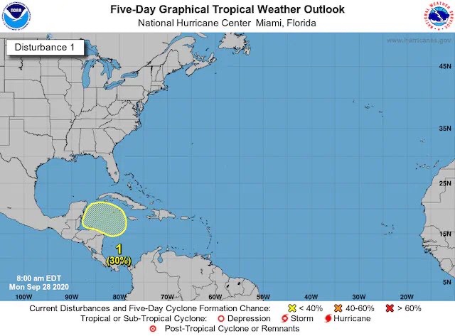
The National Hurricane Center estimates a 30 percent chance that this system will develop in the next five days. (NOAA/NHC)

Down the road, weather models continue to work toward cranking out additional systems in this area. Historically, the western Caribbean and Gulf of Mexico have been areas to closely monitor this time of year, anyway. During autumn, activity typically wanes in the Atlantic’s Main Development Region, or the stretch of marine real estate between Africa and the Lesser Antilles, while the threat of “homegrown” storms closer to the U.S. shoreline increases.

Why the 2020 Atlantic hurricane season has spun out of control

And those are the same systems that often prove more tricky to predict, as they mature closer to land and often are harder to spot from a distance.

Monday, September 28, 2020

The Wind of God’s Wrath Returns (Jeremiah 23)

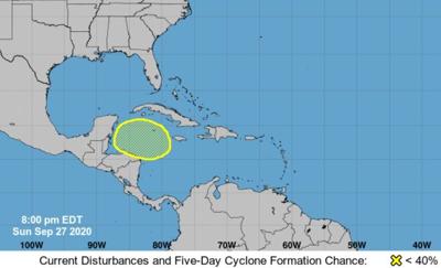
National Hurricane Center outlook, Sept. 27, 2020

The Naitonal Hurricane Center is monitoring a disturbance in the Caribbean Sea it says has a low chance of becoming a tropical depression in the next five days as of Sept. 27, 2020.Graphic via NHC

Hurricane Center: Disturbance in Caribbean has a chance to develop this week

After a few quiet days in the tropics, the week is beginning with the National Hurricane Center highlighting an area in the Caribbean Sea that has a low chance to develop into a tropical depression, forecasters said Sunday night.

“A broad area of low pressure could form over the western Caribbean Sea in a few days. Some slow development is possible late this week while the system moves slowly west-northwestward over the northwestern Caribbean,” wrote Eric Blake, a senior hurricane specialist with the NHC.

The low pressure area has a 0% chance of developing in the next two days, and a 20% chance to form in the next five days.

This season there have been 23 named storms, which is already roughly double the number for a normal season. The most recent storms were Alpha and Beta.

The next named storm will be Gamma.

The only other time the Greek alphabet was used was the 2005 season. The last named storm that season was Zeta, which didn’t dissipate until Jan. 6, 2006.

Hurricane season officially ends Nov. 30. 

Sunday, September 27, 2020

Even Alaska must face the wind of God’s wrath: Jeremiah 23

A rare hurricane force wind warning was just issued for Alaska

By Gene Norman and Allison Chinchar, CNN Meteorologists

Updated 4:19 PM EDT, Sat September 26, 2020

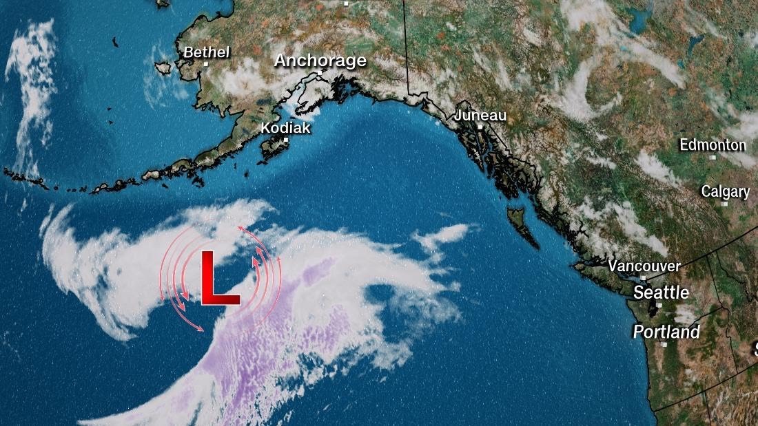
(CNN) — The National Weather Service office in Anchorage issued a rare Hurricane Force Wind Warning for the Northern Gulf of Alaska on Saturday.

Parts of the Gulf could experience hurricane force winds and waves as high as a three-story building on Sunday into early Monday, the NWS said. The warning extends up to 100 nautical miles out, including Kodiak Island and Cook Inlet.

“Models are in fairly good agreement with the storm/hurricane force low (pressure system) moving into the Gulf over the weekend so confidence is high with this system,” said the NWS office in Anchorage.

A deepening area of low pressure in the Gulf will approach the coast beginning late Saturday night. By then, winds will begin to approach 60 mph with seas building from 6 to 16 feet.

The system will rapidly intensify through Sunday, with peak winds approaching hurricane force (75 mph) in the afternoon. By late Sunday, seas could build to 27 feet, NWS said.

The biggest impact to the coast will be felt just northwest of Juneau.

In addition to the wind and waves, heavy rainfall is expected along the coast, with some places seeing between 4 to 6 inches.

Hurricane Force Wind Warnings mean sustained winds of at least 64 knots (73 mph). These warnings are not common in the Gulf of Alaska and are more typical in farther west locations, such as the Bering Sea and along the Aleutian Islands.

One category down from that is the Storm Force Wind Warning, which is more common in the Gulf. These have winds of at least 48 knots (55 mph), and occur 1 to 2 times per year, on average.

Saturday, September 26, 2020

Calm before the next wind of God‘s wrath: Jeremiah 23

After a Frenetic 7-Week Stretch, National Hurricane Center’s Outlook Map Is Finally Blank Again

At a Glance

Friday’s outlook from the National Hurricane Center had no storms or areas to watch.

This was the first time the Atlantic Basin outlook map was blank since early August.

There were 14 named storms during that stretch.

There is still about 28 percent of an average hurricane season left.

This includes the recently volatile month of October.

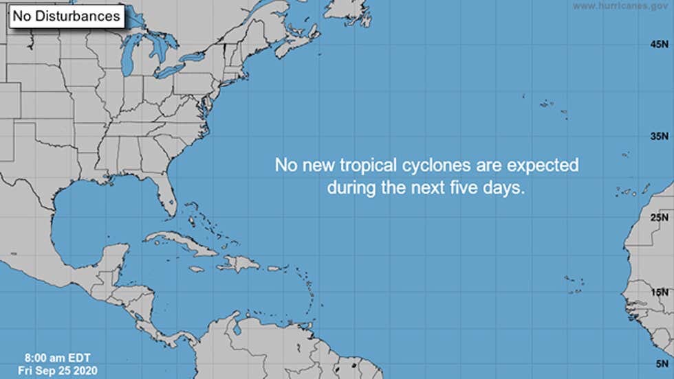
The National Hurricane Center’s Atlantic Basin outlook map was devoid of any active storms or areas to watch for the first time in almost two months as the Atlantic hurricane season finally takes a brief rest after a hectic stretch.

The outlook map on the front page of the National Hurricane Center’s website depicts current active tropical depressions, storms and hurricanes, as well as areas the NHC is monitoring for potential development over the next five days.

In recent weeks, that map has been littered with multiple storms and circles showing areas that could – and in many cases, did – develop.

However, Friday, that map finally went blank.

The NHC’s outlook map on Friday, Sept. 25, 2020, had no active storms or areas of potential development for the first time in seven weeks.

(NOAA/NHC)

That was the first time the NHC map was blank since Aug. 7, seven weeks ago.

While August and September are typically the peak months of the Atlantic hurricane season, this seven-week stretch was particularly active.

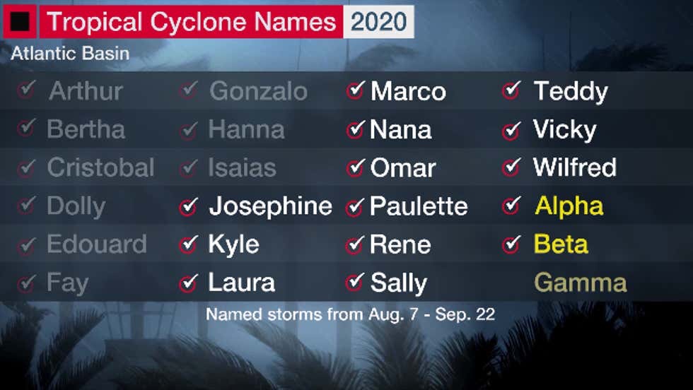
Fourteen named storms formed during this frenetic stretch, beginning with Tropical Storm Josephine and ending two letters deep into the Greek alphabet with Tropical Storm Beta.

The named storms that formed from Aug. 7 to Sept. 22, 2020, beginning with Josephine and ending with Beta.

Six of those became hurricanes and two of those – Laura and Teddy – reached Category 4 strength.

That’s roughly an entire average season’s worth of storms (13), hurricanes (7) and major hurricanes (3) compressed into seven weeks.

Four of those storms – Laura, Marco, Sally and Beta – made a mainland U.S. landfall.

Contrast the blank NHC map above with what we saw last week.

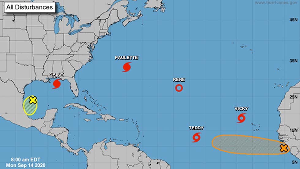
On Monday, Sept. 14, there were five active named storms at once, plus a couple of other areas the NHC was monitoring that would eventually develop.

The NHC’s outlook map on Sept. 14, 2020, at 8 a.m. EDT included five active named storms and two areas they were monitoring for development, denoted by X’s with circles.

(NOAA/NHC)

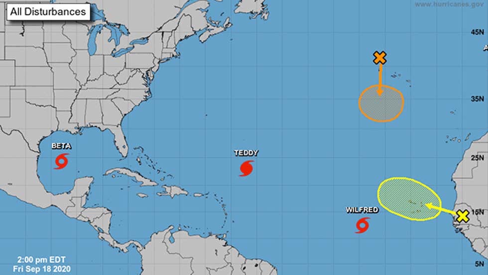
Four days later, only Teddy remained from Monday’s map, but three new storms – Wilfred, Alpha and Beta – formed in just six hours on Sept. 18, and also pushed the names list into the Greek alphabet for the second time ever.

One of the storms – Subtropical Storm Alpha – moved into Portugal. It was so far off the map, only the letter “A” could fit in the extreme northeast corner of the NHC’s map.

Same as above, but on Sept. 18, 2020, at 2 p.m. EDT. One of the active named storms at the time, Subtropical Storm Alpha, is almost off the map in the upper-right corner, with only the first letter of Alpha – “A” – visible on the map.

(NOAA/NHC)

And here’s the progression of the NHC outlooks during this stretch from Virginia Tech graduate student Tyler Stanfield.

The Lull Won’t Last Long

These quieter periods in the heart of hurricane season are typical.

In this case, an atmospheric oscillation called the Madden-Julian Oscillation (MJO) is moving into a phase to suppress convection in the tropical North Atlantic Ocean through the end of the month. This means relative quiet for tropical storms and hurricanes in the Atlantic Basin.

However, Michael Ventrice, a meteorological scientist with The Weather Company, an IBM Business, noted the MJO is forecast to return to a more supportive phase for tropical storms and hurricanes by mid-October.

October can still be an active and dangerous month – and more of a threat than August or September for some parts of the U.S.

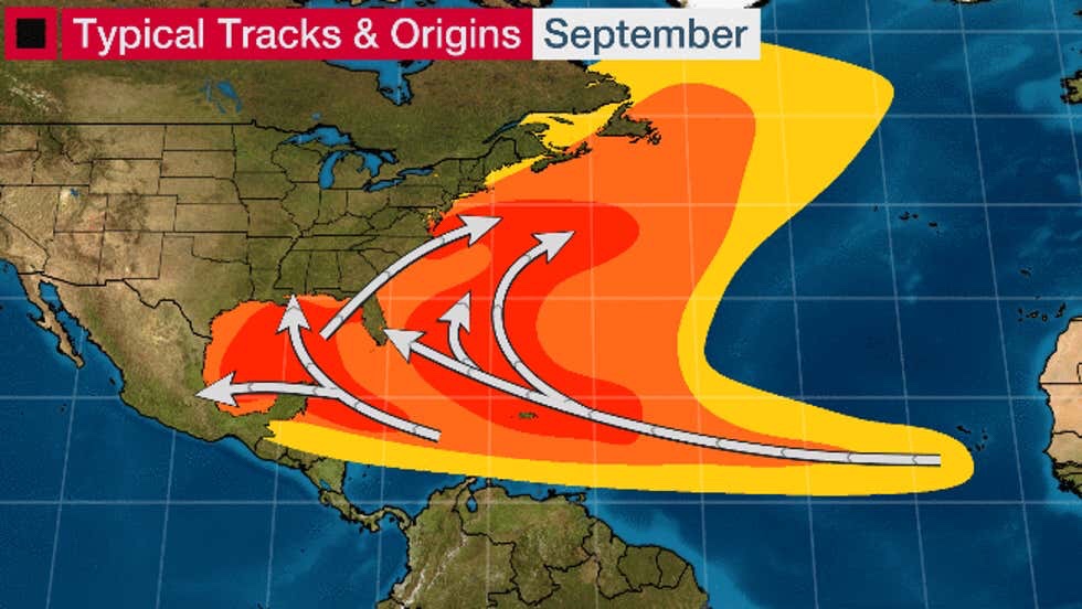
While the typical area for development shrinks westward in October compared to September, October’s storms and hurricanes often move north from the deep, warm western Caribbean Sea toward Florida, the eastern Gulf Coast, or the East Coast of the U.S.

Here are the typical areas for development of Atlantic Basin tropical storms and hurricanes in September (first image) and October (second image).

Recent October hurricanes like this include Michael, Matthew, Sandy and Wilma. All of those hurricanes were so destructive, their names were retired from future use.

In South Florida, October – not September – is the month with the most hurricane direct hits. According to NOAA’s Best Track Database, 26 October hurricanes have passed within 100 nautical miles of Miami since 1851.

An average remainder of the hurricane season would deliver another four to five named storms, two to three of which become hurricanes and one of which strengthens to a major hurricane (Category 3 or stronger), according to statistics compiled by Dr. Phil Klotzbach, a tropical scientist at Colorado State University.

Using a metric called the ACE index, which tracks not only numbers of storms but also how long they last and how strong they become, about 28% of the hurricane season’s activity remains, according to Klotzbach’s statistics.

Enjoy this break while it lasts, but keep hurricane plans ready in case another storm threatens.

The Weather Company’s primary journalistic mission is to report on breaking weather news, the environment and the importance of science to our lives. This story does not necessarily represent the position of our parent company, IBM.