By PAOLA PÉREZ, LYNNETTE CANTOS and LISA MARIA GARZA
ORLANDO SENTINEL
NOV 15, 2020 AT 3:52 PM
Hurricane Iota is quickly gaining strength as it moves closer to Central America, with forecasters at the National Hurricane Center warning the storm could bring catastrophic winds, a life-threatening storm surge and torrential rainfall to the region.
Iota is approaching Nicaragua and Honduras and may be at or near Category 4 strength at landfall, according to the latest forecast.
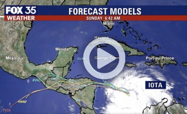
At 4 p.m. EST Sunday, Hurricane Iota was located about 140 miles east of Isla de Providencia, Colombia, and about 285 miles east-southeast of Cabo Gracias a Dios on the Nicaragua/Honduras border.
Iota’s maximum sustained winds are up to 90 mph with higher gusts, and it’s moving wes across the southwestern Caribbean Sea at 9 mph, the NHC said.
Iota is expected to become a Category 4 hurricane with 130 mph winds as it reaches Central America. It’s the 13th hurricane of the season, and once it reaches Category 3 strength, it would be the sixth major hurricane of the season.
“Rapid strengthening is expected during the next 36 hours, and Iota is forecast to be an extremely dangerous category 4 hurricane when it approaches Central America,” forecasters said.
Iota would also be the second major hurricane to form in November after Eta. This would mark the first hurricane season on record with two major hurricane formations in November, according to Colorado State University meteorologist researcher Phil Klotzbach.
Iota’s hurricane-force winds extend outward up to 25 miles from the center, while tropical-storm-force winds extend up to 115 miles from the center. The storm poses no threat to Florida.
“On the forecast track, the core of Iota will move across the southwestern Caribbean Sea today, pass near or over Providencia island late tonight or Monday, and approach the coasts of northeastern Nicaragua and eastern Honduras within the hurricane warning area late Monday,” forecasters said.
[Popular on OrlandoSentinel.com] ‘An extremely dangerous situation’: Hurricane Iota to strengthen into major, historic Category 4 storm »
Iota is expected to produce 8 to 16 inches of rain, with isolated 20- to 30-inch totals, across portions of Honduras, northern Nicaragua, Guatemala and southern Belize through Friday next week, the NHC said.
Costa Rica, Panama, El Salvador, southern Nicaragua and northern Colombia can expect between 1 to 8 inches, with isolated totals of 12 inches of rainfall.
A Hurricane Warning is in effect for the island of Providencia; the coast of Nicaragua, from its border with Honduras to Sandy Bay Sirpi; and the coast of northeastern Honduras from Punta Patuca to its border with Nicaragua. A Hurricane Watch is in effect for the island of San Andrés.
A Tropical Storm Warning is in effect for San Andrés; the coast of Nicaragua, from south of Sandy Bay Sirpi to Bluefields; and the northern coast of Honduras from west of Punta Patuca to Punta Castilla.
Tropical storm conditions are expected on the islands of San Andrés and Providencia starting Sunday afternoon into the night, with hurricane conditions coming late Sunday into early Monday. Nicaragua and Honduras can expected hurricane conditions by late Monday.
Life-threatening surf and rip current conditions are possible along parts of the coast of Colombia and the southern coasts of Hispaniola and Jamaica over the next day or two, due to swells caused by Iota, forecasters said. These swells will reach the coasts of Nicaragua and Honduras Sunday night into Monday.
Iota formed in the Caribbean on Friday afternoon, becoming the 30th named storm of a record-breaking hurricane season. It grew from a tropical depression earlier Friday.
Iota’s familiar path
Iota is moving along the same path that Tropical Storm Eta took two weeks ago, when it headed straight for Central America and also strengthened into a major hurricane.
Unlike Eta, though, Iota is not expected to turn and impact the United States.
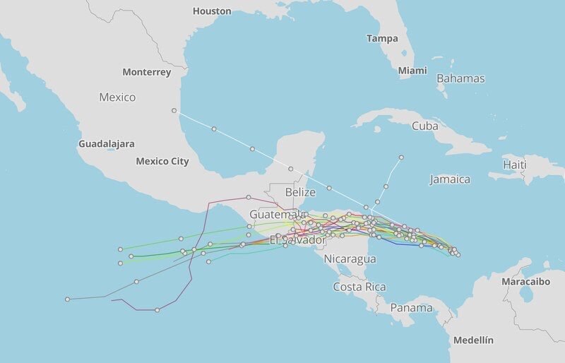
The general consensus of spaghetti models shows Hurricane Iota targeting Central America on a similar path to Hurricane Eta. One model shows Iota abruptly stopping and staying north toward Cuba, and another shooting straight for Mexico. (Screenshot Source) (Clarion Ledger Storm Tracker via Mapbox)
Eta thrashed Nicaragua and Honduras as a major Category 4 storm and weakened to a depression over the region’s mountainous terrain. It then turned back towards the Caribbean and redeveloped into a tropical storm to target the Cayman Islands, Cuba, the Bahamas and, ultimately, Florida.
“Central America is going to be impacted a lot because they have already seen very heavy rains and strong winds just about ten days ago, and more is on the way,” Fox 35 meteorologist Allison Gargaro said.
People in the region are still grappling with the aftermath of Eta, which has been blamed for the deaths of at least 120 people as its torrential rains brought flash floods and landslides to parts of Central America and Mexico.
Parts of Honduras and Nicaragua are still flooded and recovering from Eta’s damage.
After ravaging the region, Eta then turned, meandered across Cuba, the Florida Keys and around the Gulf of Mexico before slogging ashore again near Cedar Key, Florida. It then dashed across Florida and the Carolinas.
Eta made landfall over Lower Matecumbe Key late last Sunday. It dumped torrential rain across South Florida, causing flooding and whipping up winds and storm surge.
The NHC has stopped tracking Tropical Storm Eta. Forecasters predict Eta and its remnants will accelerate in speed and sprint northeast away from the U.S. (Watch Eta’s historic development here).
[Popular on OrlandoSentinel.com] How will Tropical Storm Eta affect Orlando and Central Florida »
The official end of hurricane season is two weeks away, so if the tropics continue to churn out waves with high chances for development, the world may see more record-breaking figures and potentially more dangerous storms.
The earlier tropical depression tied 2005′s 31 tropical systems. The previous record for named storms was 29, also set in 2005, which was surpassed earlier this week with the formation of Tropical Storm Theta.

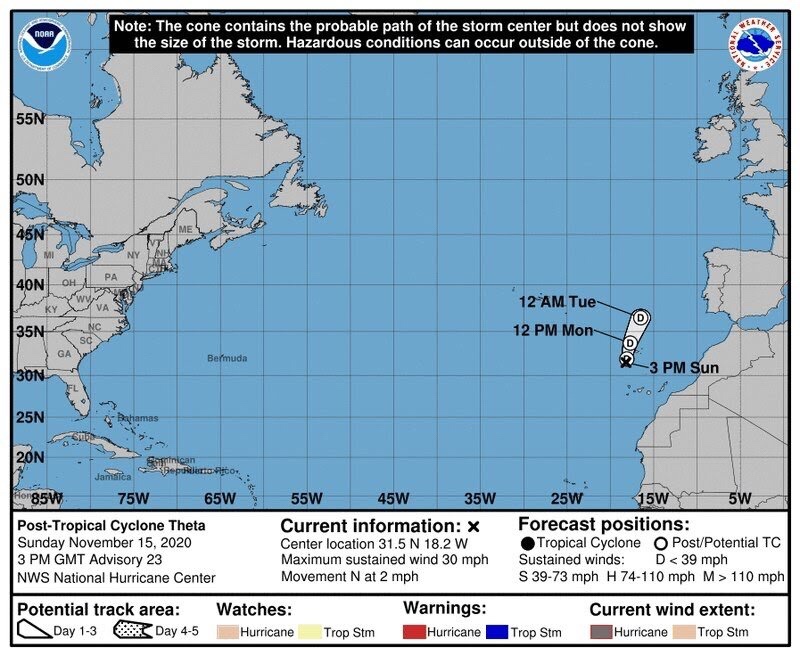
(National Hurricane Center)
Theta, now a Post-Tropical Cyclone, is continuing its eastbound journey, last located about 650 miles southeast of the Azores. The storm has weakened to 30 mph maximum sustained winds and is moving at 2 mph.
No comments:
Post a Comment