Tropical disturbance reemerges northeast of the Caribbean Sea
By ROBIN WEBB
SOUTH FLORIDA SUN SENTINEL
NOV 22, 2020 AT 2:35 PM
With just a little more than a week left in hurricane season, the National Hurricane Center is once again monitoring an area of low pressure that has resurfaced in the Atlantic basin.
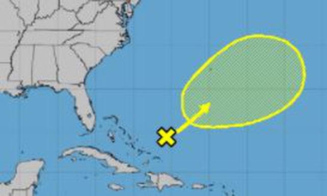
The disturbance, located to the northeast of the Caribbean on Sunday, has a 20% chance of developing in the next five days, likely somewhere between the Bahamas and Bermuda, according to the National Hurricane Center. It is expected to move in a northeastward direction.
The 2020 hurricane season became the busiest in recorded history when Tropical Storm Theta formed on Nov. 9. Only 2005 has had more hurricanes on record, at 15, Colorado State University hurricane researcher Phil Klotzbach said.
This hurricane season has been marked by storms — such as Hannah, Laura, Sally, Teddy, Gamma, Delta and Zeta — that have “rapidly intensified,” meaning a gain of at least 35 mph in wind speed in a 24-hour period. Iota, the most recent named storm, doubled that mark in the overnight hours of Nov. 15, when it intensified from a Category 2 hurricane to a Category 4. It dissipated over western El Salvador last week.
Meanwhile, a study on hurricanes in the North Atlantic was published this month in the scientific journal Nature.
The study found that these hurricanes are “staying stronger after making landfall, which suggests these storms could cause greater destruction in areas farther from the coast in the future,” according to AccuWeather.
The next named storm would be Kappa.
No comments:
Post a Comment